Related Research Articles
The Niger River is the main river of West Africa, extending about 4,180 km (2,600 mi). Its drainage basin is 2,117,700 km2 (817,600 sq mi) in area. Its source is in the Guinea Highlands in south-eastern Guinea near the Sierra Leone border. It runs in a crescent shape through Mali, Niger, on the border with Benin and then through Nigeria, discharging through a massive delta, known as the Niger Delta, into the Gulf of Guinea in the Atlantic Ocean. The Niger is the third-longest river in Africa, exceeded by the Nile and the Congo River. Its main tributary is the Benue River.

The Rio Grande in the United States or the Río Bravo del Norte in Mexico is one of the principal rivers in the southwestern United States and in northern Mexico. The length of the Rio Grande is 1,896 miles (3,051 km), making it the 4th longest river in North America by main stem. It originates in south-central Colorado, in the United States, and flows to the Gulf of Mexico. The Rio Grande drainage basin (watershed) has an area of 182,200 square miles (472,000 km2); however, the endorheic basins that are adjacent to and within the greater drainage basin of the Rio Grande increase the total drainage-basin area to 336,000 square miles (870,000 km2).
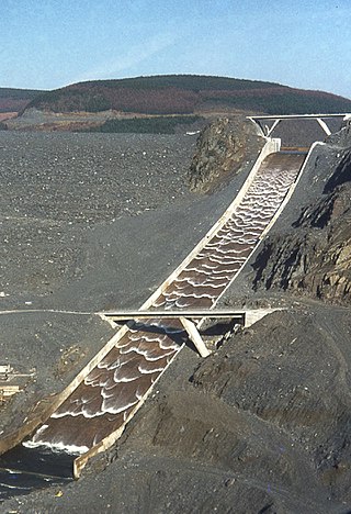
A spillway is a structure used to provide the controlled release of water downstream from a dam or levee, typically into the riverbed of the dammed river itself. In the United Kingdom, they may be known as overflow channels. Spillways ensure that water does not damage parts of the structure not designed to convey water.

Khadakwasla Dam is a dam on the Mutha River 21 km (13 mi) from the centre of the city of Pune in Maharashtra, India. The dam created a reservoir known as Khadakwasla Lake which is the main source of water for Pune and its suburbs.

New Melones Dam is an earth and rock filled embankment dam on the Stanislaus River, about 5 miles (8.0 km) west of Jamestown, California, United States, on the border of Calaveras County and Tuolumne County. The water impounded by the 625-foot-tall (191 m) dam forms New Melones Lake, California's fourth-largest reservoir, in the foothills of the Sierra Nevada east of the San Joaquin Valley. The dam serves mainly for irrigation water supply, and also provides hydropower generation, flood control, and recreation benefits.

A reservoir is an enlarged lake behind a dam. Such a dam may be either artificial, usually built to store fresh water, or it may be a natural formation.

Nagarjuna Sagar Dam is a masonry dam across the Krishna River at Nagarjuna Sagar which straddles the border between Palnadu district in Andhra Pradesh and Nalgonda district in Telangana. The dam provides irrigation water to the districts of Palnadu, Guntur, Nalgonda, Prakasam, Khammam, Krishna, and parts of West Godavari. It is also a source of electricity generation for the national grid.
A geomembrane is very low permeability synthetic membrane liner or barrier used with any geotechnical engineering related material so as to control fluid migration in a human-made project, structure, or system. Geomembranes are made from relatively thin continuous polymeric sheets, but they can also be made from the impregnation of geotextiles with asphalt, elastomer or polymer sprays, or as multilayered bitumen geocomposites. Continuous polymer sheet geomembranes are, by far, the most common.

Navajo Dam is a dam on the San Juan River, a tributary of the Colorado River, in northwestern New Mexico in the United States. The 402-foot (123 m) high earthen dam is situated in the foothills of the San Juan Mountains about 44 miles (71 km) upstream and east of Farmington, New Mexico. It was built by the U.S. Bureau of Reclamation (Reclamation) in the 1960s to provide flood control, irrigation, domestic and industrial water supply, and storage for droughts. A small hydroelectric power plant was added in the 1980s.

The environmental impact of reservoirs comes under ever-increasing scrutiny as the global demand for water and energy increases and the number and size of reservoirs increases.

Ujjani Dam, also known as Bhima Dam or Bhima Irrigation Project, on the Bhima River, a tributary of the Krishna River, is an earthfill cum Masonry gravity dam located near Ujjani village of Madha Taluk in Solapur district of the state of Maharashtra in India.
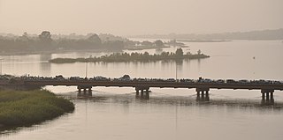
The Kandadji Dam, is a large multipurpose dam under construction on the Niger River. The site is situated near the small town of Kandadji, Tillabéri Department, Tillabéri Region, Niger, 180 km northwest of the capital Niamey. It is being built by the Haut Commissariat à l'Aménagement de la Vallée du Niger, a public body under the Primer Minister's Office.

The Bakolori Dam is in Sokoto State in northwest Nigeria. It was completed in 1978 and its reservoir filled by 1981. It is a major reservoir on the Sokoto River, a tributary of the Rima River, which in turn feeds the Niger River. Water from the dam supplies the Bakolori Irrigation Project.
The Zobe Dam is in Dutsin-Ma local government area of Katsina State in the north of Nigeria. It is an earth-fill structure with a height of 19 m and a total length of 2,750 m. The dam has a storage capacity of 179 Mca and irrigation potential of 8,000 hectares. Although the dam was completed in 1983, as of 2010 it was still not being used for water supply to Katsina city, for local irrigation or for power generation.

The Kiri Dam is in Shelleng local government area of Adamawa State in the north east of Nigeria, damming the Gongola River. It is a 1.2 km long, 20 m high zoned embankment with an internal clay blanket. The dam was mainly completed in 1982. The reservoir has a capacity of 615 million m³.
The Oyan River Dam is in Abeokuta North local government area of Ogun State in the West of Nigeria, about 20 km north west of the state capital Abeokuta. The dam crosses the Oyan River, a tributary of the Ogun River. It is used primarily to supply raw water to Lagos and Abeokuta, but has potential for use in irrigation and power generation.
The Ikere Gorge Dam is a major earth-fill dam in Iseyin local government area of Oyo State in the south west of Nigeria on the Ogun River. Reservoir capacity is 690 million m3. The dam was initiated by the military regime of General Olusegun Obasanjo and started in 1983 by the administration of Shehu Shagari. The dam was planned to generate 37.5 MW of electricity, to supply water to local communities and to Lagos and to irrigate 12,000 hectares of land. Built in 1982/1983, work on the dam was abandoned by subsequent military governments. A report for the UN in 2004 said that no irrigation had taken place so far, but efforts were being made to implement one of the five planned irrigation projects. The project was based on the sprinkler system which is difficult to manage and requires that the farmers be trained.

The Upper Wardha Dam is an earthfill straight gravity dam across the Wardha River, a tributary of the Godavari River, near Simbhora village in Morshi taluk in Amravati district in the Indian state of Maharashtra. The dam provides multipurpose benefits of irrigation, drinking water supply, flood control and hydropower generation.
Keswick Dam is a concrete gravity dam on the Sacramento River about 2 miles (3.2 km) northwest of Redding, California. Part of the U.S. Bureau of Reclamation's Central Valley Project, the dam is 157 feet (48 m) high and impounds the Keswick Reservoir, which has a capacity of 23,800 acre⋅ft (29,400,000 m3). The dam's power plant has three turbines with a generating capacity of 117 megawatts (MW), which, in 1992, was uprated from its original 75 MW. The dam and reservoir serve as an afterbay to regulate peaking power releases from the Shasta Dam upstream.
References
- ↑ "Jibiya Dam" (PDF). Sembenelli Consulting. Archived from the original (PDF) on 2011-07-16. Retrieved 2010-05-21.
- ↑ G. Den Hoedt, ed. (1990). Geotextiles, Geomembranes and Related Products: Canals, reservoirs and dams. Taylor & Francis. p. 419ff. ISBN 90-6191-121-4.
- ↑ Enplan Group (September 2004). "Review of The Public Sector Irrigation in Nigeria" (PDF). Federal Ministry of Water Resources / UN Food & Agricultural Organization. Archived from the original (PDF) on 2017-05-18. Retrieved 2010-05-21.
- ↑ "Presidential candidate 'is not accessible'". Independent Onlone. January 29, 2007. Retrieved 2010-05-21.
- ↑ L. Berga, ed. (18 June 2006). Dams and Reservoirs, Societies and Environment in the 21st Century: Proceedings of the International Symposium on Dams in the Societies of the 21st Century, 22nd International Congress on Large Dams. Taylor & Francis. p. 316. ISBN 0-415-40423-1.