The Rift Valley lakes are well known for the evolution of at least 800 cichlid fish species that live in their waters. More species are expected to be discovered.[1]
Lake Malawi and Lake Tanganyika have formed in the various valleys of the East African Rift zone. Lake Kivu's "still waters ... hide another face: dissolved within are billions of cubic meters of flammable methane and more still of carbon dioxide, the result of volcanic gases seeping in."[2]
Ethiopian Rift Valley lakes national park
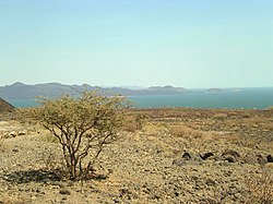
The Ethiopian Rift Valley lakes are the northernmost of the African Rift Valley lakes. In central Ethiopia, the Main Ethiopian Rift, also known as the Great Rift Valley, splits the Ethiopian Highlands into northern and southern halves, and the Ethiopian Rift Valley lakes occupy the floor of the rift valley between the two highlands. Most of the Ethiopian Rift Valley lakes do not have an outlet, and most are alkaline. Although the Ethiopian Rift Valley lakes are of great importance to Ethiopia's economy, as well as being essential to the survival of the local people, there were no intensive and extensive limnological studies undertaken of these lakes until recently.[3]
The major ones are
Lake Abaya (areal extent 1,162 square kilometres (449mi2), elevation 1,285 metres (4,216ft), maximum depth 13.1 metres (43ft)), the largest Ethiopian Rift Valley lake by surface area
Lake Chamo (areal extent 551 square kilometres (213mi2), elevation 1,235 metres (4,052ft), maximum depth 14 metres (46ft))
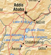
Lake Zway or Dambal (areal extent 485 square kilometres (187mi2), elevation 1,636 metres (5,367ft), maximum depth 8.9 metres (29ft))
Lake Shala (areal extent 329 square kilometres (127mi2), elevation 1,558 metres (5,112ft), maximum depth 266 metres (873ft)), the deepest Ethiopian Rift Valley lake and the largest by water volume
Koka Reservoir (areal extent 250 square kilometres (97mi2), elevation 1,590 metres (5,220ft), maximum depth not listed)
Lake Langano (areal extent 230 square kilometres (89mi2), elevation 1,585 metres (5,200ft), maximum depth 46 metres (151ft))
Lake Abijatta (areal extent 205 square kilometres (79mi2), elevation 1,573 metres (5,161ft), maximum depth 14 metres (46ft))
Lake Awasa (areal extent 129 square kilometres (50mi2), elevation 1,708 metres (5,604ft), maximum depth 10 metres (33ft))
Lake Tana, the source of the Blue Nile, lies in the Ethiopian highlands north of the Rift Valley; however, it is not a Rift Valley lake.[4]
South of the Ethiopian highlands, the rift valley splits into two major troughs. The Eastern Rift is home to the Kenyan Rift Valley lakes, while most of the Central African Rift Valley lakes lie in the Western Rift. This area includes the Gregory Rift in Kenya and Tanzania.
Kenya
The Kenyan section of the Rift Valley is home to eight lakes, of which three are freshwater and the rest alkaline.[5] Of the latter, the shallow soda lakes of the Eastern Rift Valley have crystallised salt turning the shores white and are famous for the large flocks of flamingo that feed on crustaceans.
Lake Baringo: second largest of the Kenyan Rift Valley lakes.
Some of the Rift Valley lakes. From left to right they are Lake Upemba, Lake Mweru, Lake Tanganyika (largest), and Lake Rukwa. This image spans the SE corner of the Democratic Republic of the Congo, NE Zambia, and southern Tanzania.
The lakes of the Western or Albertine Rift, with Lake Victoria, include the largest, deepest, and oldest of the Rift Valley Lakes. They are also referred to as the Central African lakes. Lakes Albert, Victoria, and Edward are part of the Nile River basin.
Lake Victoria (elevation 1,134 metres (3,720ft)), with an area of 68,800 square kilometres (26,600mi2), is the largest lake in Africa. It is not in the Rift Valley, instead occupying a depression between the eastern and western rifts formed by the uplift of the rifts to either side. Lakes Victoria, Tanganyika, and Malawi are sometimes collectively known as the African Great Lakes.
Lake Albert (5,300 square kilometres (2,000mi2), elevation 615 metres (2,018ft)) is the northernmost lake in the western rift.
Lake Edward (2,325 square kilometres (898mi2), elevation 912 metres (2,992ft)) drains north into Lake Albert
Lake Kivu (2,220 square kilometres (860mi2), elevation 1,460 metres (4,790ft)) empties into Lake Tanganyika via the Ruzizi River.
Lake Tanganyika (32,900 square kilometres (12,700mi2), elevation 773 metres (2,536ft)) is the largest and deepest of the Rift Valley lakes (more than 1,400 metres (4,600ft)), and is the second deepest fresh water lake on the planet (after Lake Baikal).[1] Below roughly 200 meters depth, its water is anoxic and devoid of life besides anoxic bacteria.[4] It is very sensitive to climate.[6] It is part of the Congo River basin, feeding into the River Congo via the Lukuga River.
Southern Rift Valley lakes (Tanzania and Malawi)
The Southern Rift Valley lakes are like the Western Rift Valley lakes in that, with one exception, they are freshwater lakes.
Lake Rukwa (about 5,670 square kilometres (2,190mi2) but quite variable) in Tanzania is the alkaline exception, lying south-east of Tanganyika, and has no outlet.
Lake Malawi (30,000 square kilometres (12,000mi2), elevation 500 metres (1,600ft)), the second largest and second deepest of the Rift Valley lakes at over 700 metres (2,300ft), is drained by the Shire River, a tributary of the Zambezi River. Also known as Lake Nyasa.
Lake Chilwa (1,750 square kilometres (680mi2), elevation 622 metres (2,041ft)) has no outlet but extensive wetlands. It is the southernmost of the Rift Valley lakes.
Other lakes of the Great Rift Valley
Lake Mweru (5,120 square kilometres (1,980mi2)[7] elevation 922 m) lies in the Lake Mweru-Luapula graben, which is a branch off the Albertine rift.
Lake Mweru Wantipa (1,500 square kilometres (580mi2), elevation 930 metres (3,050ft)) is a marshy lake between lakes Tanganyika and Mweru, and is endorheic but may overflow into Lake Mweru at times of very high flood.
↑Renaut, Robin; Owen, Richard (2023). The Kenya Rift Lakes: Modern and Ancient - Limnology and Limnogeology of Tropical Lakes in a Continental Rift. Springer. ISBN9783642250545.
↑Plisnier P.-D., Chitamwebwa D., Mwape L., Tshibangu K., Langenberg V., Coenen E. (1999). "Limnological annual cycle inferred from physical-chemical fluctuations at three stations of Lake Tanganyika". Hydrobiologia. 407: 45–58. doi:10.1023/A:1003762119873. hdl:2268/294749. S2CID24637697.{{cite journal}}: CS1 maint: multiple names: authors list (link)
This page is based on this Wikipedia article Text is available under the CC BY-SA 4.0 license; additional terms may apply. Images, videos and audio are available under their respective licenses.