The geography of Israel is very diverse, with desert conditions in the south, and snow-capped mountains in the north. Israel is located at the eastern end of the Mediterranean Sea in West Asia. It is bounded to the north by Lebanon, the northeast by Syria, the east by Jordan and the West Bank, and to the southwest by Egypt. To the west of Israel is the Mediterranean Sea, which makes up the majority of Israel's 273 km (170 mi) coastline, and the Gaza Strip. Israel has a small coastline on the Red Sea in the south.

The Nile is a major north-flowing river in northeastern Africa. It flows into the Mediterranean Sea. The Nile is the longest river in Africa and has historically been considered the longest river in the world, though this has been contested by research suggesting that the Amazon River is slightly longer. Of the world's major rivers, the Nile is one of the smallest, as measured by annual flow in cubic metres of water. About 6,650 km (4,130 mi) long, its drainage basin covers eleven countries: the Democratic Republic of the Congo, Tanzania, Burundi, Rwanda, Uganda, Kenya, Ethiopia, Eritrea, South Sudan, Sudan, and Egypt. In particular, the Nile is the primary water source of Egypt, Sudan and South Sudan. Additionally, the Nile is an important economic river, supporting agriculture and fishing.

Lake Abaya is a lake in the Southern Nations, Nationalities, and Peoples' Region of Ethiopia. It is located in the Main Ethiopian Rift, east of the Guge Mountains.
The Rift Valley lakes are a series of lakes in the East African Rift valley that runs through eastern Africa from Ethiopia in the north to Malawi in the south, and includes the African Great Lakes in the south. These include some of the world's oldest lakes, deepest lakes, largest lakes by area, and largest lakes by volume. Many are freshwater ecoregions of great biodiversity, while others are alkaline "soda lakes" supporting highly specialised organisms.

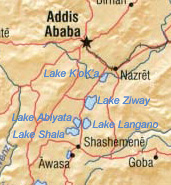
Hora-Dambal, also known as Lake Zway or Dambal, is one of the freshwater Rift Valley lakes of Ethiopia. It is the home of the Zay people. Located about 100 miles south of Addis Ababa, on the border between the Oromia and Southern Nations, Nationalities, and Peoples' Region, the woredas holding the lake's shoreline are Adami Tullu Jido Kombolcha, Dugda, and Batu town. The town of Batu lies on the lake's western shore. The lake is fed primarily by two rivers, the Meki from the west and the Katar from the east, and is drained by the Bulbula which empties into Lake Abijatta. The lake's catchment has an area of 7,025 square kilometers.

Abijatta-Shalla National Park is a national park in Ethiopia. It is located in the Oromia Region and the Ethiopian Highlands region, 200 kilometers south of Addis Ababa, and east of the Batu–Shashamane highway.

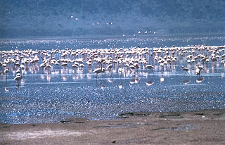
Lake Abijatta is an alkaline lake in Ethiopia. It lies in the Main Ethiopian Rift valley south of Addis Ababa, in the Abijatta-Shalla National Park.

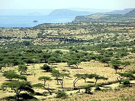
Lake Langano is a lake in the Oromia Region of Ethiopia, exactly 200 kilometers by road south of the capital, Addis Ababa, on the border between the East Shewa Zone and Arsi Zones. It is located to the east of Lake Abijatta in the Main Ethiopian Rift at an elevation of 1,585 meters.

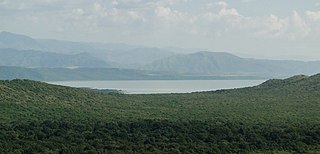
Halaba is a zone in the Central Ethiopia Regional State. It is named after the Halaba people, and covers part of their homeland. Located in the Great Rift Valley, Halaba zone is bordered on the south by an exclave of Hadiya Zone, on the southwest by the Kembata Tembaro Zone, on the west and north by Hadiya Zone, on the north east by Lake Shala, and on the east by Oromia Region; the Bilate River, which is its major body of water, defines its western boundary. The administrative center is halaba Kulito.
Lake Chamo is a lake in the Southern Nations, Nationalities, and Peoples' Region of southern Ethiopia. Located in the Main Ethiopian Rift, it is at an elevation of 1,110 meters. The Chamo lake is just to the south of Lake Abaya and the city of Arba Minch, east of the Guge Mountains, and west of the Amaro Mountains.
Seraro is one of the woredas in the Oromia Region of Ethiopia. Part of the West Arsi Zone located in the Great Rift Valley, Seraro is bordered on the south and west by the Southern Nations, Nationalities and Peoples' Region, on the north by Shala, and on the east by Naannawa Shashamane; its western boundary is defined by the course of the Bilate River. The administrative center of this woreda is Loke.
Arsi Negele is a woreda in Oromia Region, Ethiopia. It is named after its administrative center, Arsi Negele. Part of the West Arsi Zone located in the Great Rift Valley, Arsi Negele is bordered on the south by Naannawa Shashamane and Kofale, on the southwest by Lake Shala which separates it from Shala, on the west by the Southern Nations, Nationalities and Peoples Region, on the north by East Shewa with which it shares the shores of Lakes Abijatta and Langano, and on the east by the Heban Arsi, Qore woreda and small portion by Arsi Zone.
Naannawa Shashamane is a woreda in Oromia Region, Ethiopia. It is named after the town of Shashamene what was separated from this woreda. Part of the West Arsi Zone located in the Great Rift Valley, Shashamene is bordered on the south by the Southern Nations, Nationalities and Peoples Region, on the west by Shala, on the north by Arsi Negele, on the east by the Kore, and on the southeast by Kofele. The largest town in Shashamene is Kuyera.

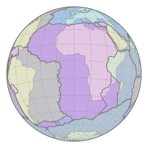
The Great Rift Valley is part of an intra-continental ridge system that runs through Kenya from north to south. It is part of the Gregory Rift, the eastern branch of the East African Rift, which starts in Tanzania to the south and continues northward into Ethiopia. It was formed on the "Kenyan Dome" a geographical upwelling created by the interactions of three major tectonics: the Arabian, Nubian, and Somalian plates. In the past, it was seen as part of a "Great Rift Valley" that ran from Madagascar to Syria. Most of the valley falls within the former Rift Valley Province.
Shala is one of the Aanaas in the Oromia of Ethiopia. It was separated from Seraro woreda. Part of the West Arsi Zone located in the Great Rift Valley, Shala is bordered on the south by Seraro, on the west by the Southern Nations, Nationalities and Peoples' Region, on the north by Shala Lake which separates it from Arsi Negele, and on the east by Naannawa Shashamane(Aanaa); its western boundary is defined by the course of the Bilate River. The administrative center of this woreda is Aje.

The Shalë or Lumi i Shalës is a river flowing inside the Albanian Alps in northern Albania. Its source is near the village of Theth, close to the border with Montenegro in the Alps of Albania National Park. It drains the central part of the alps to the south and flows into the artificially dammed Drin as lake Koman near the village Telum.
The geology of Malawi formed on extremely ancient crystalline basement rock, which was metamorphosed and intruded by igneous rocks during several orogeny mountain building events in the past one billion years. The rocks of the Karoo Supergroup and newer sedimentary units deposited across much of Malawi in the last 251 million years, in connection with a large rift basin on the supercontinent Gondwana and the more recent rifting that has created the East African Rift, which holds Lake Malawi. The country has extensive mineral reserves, many of them poorly understood or not exploited, including coal, vermiculite, rare earth elements and bauxite.

The geology of Tanzania began to form in the Precambrian, in the Archean and Proterozoic eons, in some cases more than 2.5 billion years ago. Igneous and metamorphic crystalline basement rock forms the Archean Tanzania Craton, which is surrounded by the Proterozoic Ubendian belt, Mozambique Belt and Karagwe-Ankole Belt. The region experienced downwarping of the crust during the Paleozoic and Mesozoic, as the massive Karoo Supergroup deposited. Within the past 100 million years, Tanzania has experienced marine sedimentary rock deposition along the coast and rift formation inland, which has produced large rift lakes. Tanzania has extensive, but poorly explored and exploited natural resources, including coal, gold, diamonds, graphite and clays.
The geology of Uganda extends back to the Archean and Proterozoic eons of the Precambrian, and much of the country is underlain by gneiss, argillite and other metamorphic rocks that are sometimes over 2.5 billion years old. Sedimentary rocks and new igneous and metamorphic units formed throughout the Proterozoic and the region was partially affected by the Pan-African orogeny and Snowball Earth events. Through the Mesozoic and Cenozoic, ancient basement rock has weathered into water-bearing saprolite and the region has experienced periods of volcanism and rift valley formation. The East Africa Rift gives rise to thick, more geologically recent sediment sequences and the country's numerous lakes. Uganda has extensive natural resources, particularly gold.
The geology of Africa is varied and complex, and gives rise to the wide variety of landscapes found across the continent.