Lake Logipi

Last updated
Lake Logipi
Kenya relief location map.jpg
Red pog.svg
Lake Logipi
Africa relief location map.jpg
Red pog.svg
Lake Logipi
Coordinates 2°14′N36°34′E / 2.233°N 36.567°E / 2.233; 36.567 Coordinates: 2°14′N36°34′E / 2.233°N 36.567°E / 2.233; 36.567
Primary inflows hot springs
Basin  countriesKenya
Max. length6 km (3.7 mi)
Max. width3 km (1.9 mi)
Max. depth3–5 m (9.8–16.4 ft)

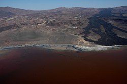
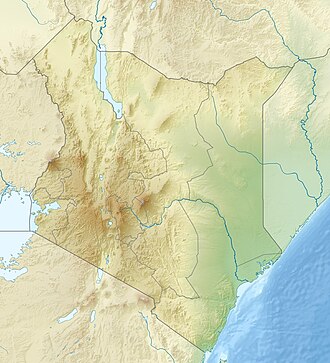
Lake Logipi is a saline, alkaline lake that lies at the northern end of the arid Suguta Valley in the northern Kenya Rift. It is separated from Lake Turkana by the Barrier volcanic complex, a group of young volcanoes that last erupted during the late 19th century or early 20th century. Saline hot springs discharge on the northern shoreline of Lake Logipi and at Cathedral Rocks near its southern limit, and help to maintain water at times of extreme aridity. During the rainy season, the lake is also recharged from the Suguta River which flows northward along the Suguta Valley, periodically forming a temporary lake (Lake Alablab) that unites with Logipi.

Lake Logipi has a maximum depth of 3 to 5 m, and is about 6 km wide by 3 km long. Its waters are of sodium bicarbonate composition with a pH of 9.5-10.5 and salinity (total dissolved salts) that varies from less than 20 g/L to greater than 50 g/L. Efflorescent salt crusts (trona) are present around its margins. Flamingoes frequently inhabit the saline waters feeding on cyanobacteria (Arthrospira spp. - formerly termed Spirulina) and other plankton. [1] [2]

Lake Turkana extended after extreme rainfalls in 2020 and overflowed Lake Logipi. [3]

See also

Related Research Articles

Geography of Kenya Geographical features of Kenya

The geography of Kenya is diverse, varying amongst its 47 counties. Kenya has a coastline on the Indian Ocean, which contains swamps of East African mangroves. Inland are broad plains and numerous hills. Kenya borders South Sudan to the northwest, Uganda to the west, Somalia to the east, Tanzania to the south, and Ethiopia to the north.

Lake Turkana Alkaline lake on the border of Ethiopia and Kenya

Lake Turkana, formerly known as Lake Rudolf, is a lake in the Kenyan Rift Valley, in northern Kenya, with its far northern end crossing into Ethiopia. It is the world's largest permanent desert lake and the world's largest alkaline lake. By volume it is the world's fourth-largest salt lake after the Caspian Sea, Issyk-Kul, and Lake Van, and among all lakes it ranks 24th.

Rift Valley lakes Group of lakes in the East African Rift

The Rift Valley lakes are a series of lakes in the East African Rift valley that runs through eastern Africa from Ethiopia in the north to Malawi in the south, and includes the African Great Lakes in the south. These include some of the world's oldest lakes, deepest lakes, largest lakes by area, and largest lakes by volume. Many are freshwater ecoregions of great biodiversity, while others are alkaline "soda lakes" supporting highly specialised organisms.

Lake Bogoria Body of water

Lake Bogoria is a saline, alkaline lake that lies in a volcanic region in a half-graben basin south of Lake Baringo, Kenya, a little north of the equator. Lake Bogoria, like Lake Nakuru, Lake Elementeita, and Lake Magadi further south in the Rift Valley, and Lake Logipi to the north, is home at times to one of the world's largest populations of lesser flamingos. The lake is a Ramsar site and Lake Bogoria National Reserve has been a protected National Reserve since November 29, 1973. Lake Bogoria is shallow, and is about 34 km long by 3.5 km wide, with a drainage basin of 700 km2. It is Located in Baringo County.

Lake Magadi Lake Kajiado County, Kenya

Lake Magadi is the southernmost lake in the Kenyan Rift Valley, lying in a catchment of faulted volcanic rocks, north of Tanzania's Lake Natron. During the dry season, it is 80% covered by soda and is well known for its wading birds, including flamingos.

Lake Abbe A lake on the border of Djibouti and Ethiopia

Lake Abbe, also known as Lake Abhe Bad, is a salt lake, lying on the Ethiopia-Djibouti border. It is one of a chain of six connected lakes, which also includes lakes Gargori, Laitali, Gummare, Bario and Afambo. The lake is the ultimate destination of the Awash River, which is at the center of the Afar Depression. Lake Abbe is considered one of the most inaccessible areas of the earth. The water itself is known for its flamingos. The scenery is unique.

Suguta Valley

The Suguta Valley, also known as the Suguta Mud Flats, is an arid part of the Great Rift Valley in Kenya (Africa), directly south of Lake Turkana.

Turkana County County in Kenya

Turkana County is a county in the former Rift Valley Province of Kenya. It is Kenya's largest county by land area, and also its northwesternmost. It is bordered by the countries of Uganda to the west; South Sudan and Ethiopia, including the disputed Ilemi Triangle, to the north and northeast; and Lake Turkana to the east. To the south and east, neighbouring counties in Kenya are West Pokot, Baringo and Samburu Counties, while Marsabit County is on the opposite shore of Lake Turkana. Turkana's capital and largest town is Lodwar. The county had a population of 926,976 at the 2019 census.

Namarunu

Namarunu is a shield volcano located in the Great Rift Valley, Kenya.

<span class="mw-page-title-main">Chalbi Desert</span>

The Chalbi Desert is a small desert in northern Kenya near the border with Ethiopia. It is east of Lake Turkana and contains North Horr. Marsabit is the closest major urban center.

The Barrier is an active shield volcano located in the north of Kenya. It is last known to have erupted in 1921.

Lokori is a Turkana settlement in Kenya's North Eastern Province, adjacent to the Kerio River. The settlement's inhabitants are traditionally pastoralists. Lokori is home to a number of prehistoric Namoratunga rock art and burial sites.

<span class="mw-page-title-main">Soda lake</span> Lake that is strongly alkaline

A soda lake or alkaline lake is a lake on the strongly alkaline side of neutrality, typically with a pH value between 9 and 12. They are characterized by high concentrations of carbonate salts, typically sodium carbonate, giving rise to their alkalinity. In addition, many soda lakes also contain high concentrations of sodium chloride and other dissolved salts, making them saline or hypersaline lakes as well. High pH and salinity often coincide, because of how soda lakes develop. The resulting hypersaline and highly alkalic soda lakes are considered some of the most extreme aquatic environments on Earth.

Great Rift Valley, Kenya Part of an intra-continental ridge system that runs through Kenya

The Great Rift Valley is part of an intra-continental ridge system that runs through Kenya from north to south. It is part of the Gregory Rift, the eastern branch of the East African Rift, which starts in Tanzania to the south and continues northward into Ethiopia. It was formed on the "Kenyan Dome" a geographical upwelling created by the interactions of three major tectonics: the Arabian, Nubian, and Somalian plates. In the past, it was seen as part of a "Great Rift Valley" that ran from Madagascar to Syria. Most of the valley falls within the former Rift Valley Province.

Gregory Rift

The Gregory Rift is the eastern branch of the East African Rift fracture system. The rift is being caused by the separation of the Somali plate from the Nubian plate, driven by a thermal plume. Although the term is sometimes used in the narrow sense of the Kenyan Rift, the larger definition of the Gregory Rift is the set of faults and grabens extending southward from the Gulf of Aden through Ethiopia and Kenya into Northern Tanzania, passing over the local uplifts of the Ethiopian and Kenyan domes. Ancient fossils of early hominins, the ancestors of humans, have been found in the southern part of the Gregory Rift.

Turkana Basin Large endorheic basin mainly in Kenya and Ethiopia

The greater Turkana Basin in East Africa determines a large endorheic basin, a drainage basin with no outflow centered around the north-southwards directed Gregory Rift system in Kenya and southern Ethiopia. The deepest point of the basin is the endorheic Lake Turkana, a brackish soda lake with a very high ecological productivity in the Gregory Rift.

The Suguta River is a seasonal river in the Great Rift Valley in Kenya (Africa), directly south of Lake Turkana. It flows northward through the Suguta Valley in the rainy season, forming the temporary Lake Alablad, a dry lake that combines with Lake Logipi at the northern end of the valley.

<span class="mw-page-title-main">Lake Suguta</span>

Lake Suguta is a former lake in Africa. It formed in the Suguta Valley, which is part of the East African Rift, south of Lake Turkana during the Holocene African humid period.

Mutai is a term used by the Maa-speaking communities of Kenya to describe a period of wars, usually triggered by disease and/or drought and affecting widespread areas of the Rift Valley region of Kenya. According to Samburu and Maasai folklore, periods of Mutai occurred during the nineteenth century.

References

  1. Mathea, Chege David (November 1, 2009). "OUR LAKES, OUR FUTURE" (PDF). International Lake Environment Committee Foundation. Archived from the original (PDF) on April 26, 2012. Retrieved 2011-12-29.
  2. Harper, David M.; Tebbs, Emma; Bell, Olivia; Robinson, Victoria J. (2016), "Conservation and Management of East Africa's Soda Lakes", Soda Lakes of East Africa, Springer International Publishing, pp. 345–364, doi:10.1007/978-3-319-28622-8_14, ISBN   978-3-319-28620-4
  3. "A drowning world: Kenya's quiet slide underwater". the Guardian. 2022-03-17. Retrieved 2022-03-23.