Turkana County

Last updated

Turkana County
Flag of Turkana County.gif
Seal of Turkana County.png
Turkana County in Kenya.svg
Location of Turkana County (red) including the disputed Elemi Triangle (diagonally striped red)
Coordinates: 3°09′N35°21′E / 3.150°N 35.350°E / 3.150; 35.350
CountryFlag of Kenya.svg  Kenya
Formed4 March 2013
Capital Lodwar
Government
   Governor Jeremiah Lomorukai
Area
  Total98,597.8 km2 (38,068.8 sq mi)
Elevation
1,138 m (3,734 ft)
Population
 (2019)
  Total926,976
  Density9.4/km2 (24/sq mi)
Time zone UTC+3 (EAT)
Website www.turkana.go.ke

Turkana County is a county in the former Rift Valley Province of Kenya. It is Kenya's second largest county by land area of 98,597.8km2 followed by Marsabit County with an area of 71,597.8km2. It is bordered by the countries of Uganda to the west; South Sudan and Ethiopia, including the disputed Ilemi Triangle, to the north and northeast; and Lake Turkana to the east. To the south and east, neighbouring counties in Kenya are West Pokot, Baringo and Samburu Counties, while Marsabit County is on the opposite (i.e. eastern) shore of Lake Turkana. Turkana's capital and largest town is Lodwar. The county had a population of 926,976 at the 2019 census. [1]

Contents

History

Four sites of Stone Age cultures are situated upon tributaries along the west side of Lake Turkana in West Turkana; at Lokalalei, Kokiselei and Nadungu, and became of interest to archaeology beginning sometime during 1988. [2] [3] [4]

The earliest late Stone Age industries in prehistory were found in Turkana, at the site of Lomekwi, and date to 3,300,000 years. [5] [6] At the archaeological site of Nataruk, in Southwest Turkana, scientists have discovered the oldest evidence of inter-group conflict in the past, establishing that warfare occurred between groups of hunter-gatherers. [7]

From 1900 until 1926, the British colonial administration in Kenya gradually established control over the Turkana people. [8] and by 1926, the Turkana people were fully under the control of the British colonial administration, who subsequently forcibly restricted their movements to the Turkana region. [9] [10]

In 1958, the district experienced an influx of a number of people classified as belonging to the Turkana people. These had been expelled from the Kenyan town of Isiolo, and forcibly relocated to the Turkana district by the colonial administration. [11]

The district maintained an all but complete isolation until 1976 when road-blocks leading to the district were lifted by the Kenyan government. [12]

In 2000, the people in the north of the county were reported as being harassed by marauding Ethiopians, and were consequently forced to relocate in southern areas. [13]

Population

Historical population
YearPop.±%
1979 142,702    
1989 184,060+29.0%
1999 450,860+145.0%
2009 855,399+89.7%
2019 926,976+8.4%
source: [14]

Religion

Religion in Turkana County [15]

Religion (2019 Census)Number
Catholicism 406,439
Protestant 265,802
Evangelical Churches 87,298
African instituted Churches 22,498
Orthodox 2,806
Other Christian 17,210
Islam 30,776
Hindu 134
Traditionists43,412
Other8,773
Atheists 25,361
Don't Know11,221
Not Stated480

Language

Turkana is known in the local language as ng'turkana. [16] Some place names in the country are attributed to the language of the Pokot and Samburu peoples, representing a tradition in the area of inhabitation by these peoples prior to displacement by the Turkana. [17]

Geography

The county is within the boundaries of the former Rift Valley province. [18] According to data provided during 1991 the majority of the population at that time lived by way of farming. [19] With an area of nearly 77,000 km2, Turkana is the largest county, including the area covered by Lake Turkana, in Kenya.

Turkana County is emerging to be a major source of electric power in Kenya. Kengen's Turkwel Hydro Power Plant, situated on the southwest of Turkana County, produces hydroelectric power which is connected to the national power grid at Lessos. The county is current subject of crude oil exploration in Block 10BB and Block 13T and has potential for geothermal, solar and wind energy.

Kekarongole and Katilu had irrigation networks made commencing sometime during or after 1975. [20]

Rainfall measurements per annum (1982 data) is recorded as less than ten inches; with a range of between 115mm and 650mm. [21] [22]

There were thirteen drought periods in a period of 50 years beginning 1938. [23]

Economics

Turkana is the poorest region in Kenya. [24] The county is, however, experiencing upward reviews due to ongoing mineral explorations and inventions, especially of oil and water resources. Turkana County residents are also enjoying the fruits of devolution. Devolution of power in Kenya is viewed as a blessing for the forgotten people of Turkana. It has been received in the sub- counties with much appreciation due to its direct benefits to the citizens. The current administration shares out these benefits equally to all sub counties in addition to enhancing citizen participation in development activities.

On 26 March 2012, Kenyan President Mwai Kibaki announced that oil had been discovered in Turkana County after exploratory drilling by Anglo-Irish firm Tullow Oil, and he further stated that:

It is... the beginning of a long journey to make our country an oil producer, which typically takes in excess of three years. We shall be giving the nation more information as the oil exploration process continues. [25]

Gold panning was reported (2005) as occurring at Lochoremoit, Namoruputh, Lokiriama and Ng' akoriyiek. [26]

According to Barrett (2001) cited in Watson the wealth of a person is kept in the form of cattle. [27]

Figures stated as of 1998 stated an average estimated herd size of 15–20. [28]

In 2013 it was announced by UNESCO [29] that large reserves of groundwater had been discovered in Turkana County. The water was discovered using satellite exploration technology then confirmed by drilling. [30] The extraction of the water began in 2014 and it is being piped to provide water to Lodwar town for irrigation and water for the people. [31] However, this project was later abandoned when it was found that the water in the aquifer was too salty to be treated or to be used for other purposes. [32]

Government [Turkana County Government Website: http://www.turkana.go.ke/]

Promulgation of the Constitution of Kenya 2010 marked a momentous point in the country's history. The Constitution provided for, among others, enhanced checks and balances within the government, an enhanced role of Parliament and citizens, an independent judiciary, and a most progressive Bill of Rights. . Turkana County is one of the 47 counties of Kenya. The county is led by H.E. Governor Jeremiah Lomorukai, [33] and Turkana County has 10 Ministries.

Travel

The county is connected to Nairobi through regular commercial flights to Lodwar airport. [34] [35] The World Food Programme runs a special UN Humanitarian Air Service for UN and INGO staff. [36]

County subdivisions

Local authorities (councils)
AuthorityTypePopulation*Urban pop.*
Lodwar Municipality1,000,00016,981
TurkanaCounty414,96326,563
Total450,86043,544
* 1999 census. Source:
Administrative divisions
DivisionPopulation*Population
density
Headquarters
Central35,91945Lodwar
Kaaling24,0533
Kainuk11,7997 Kainuk
Kakuma97,11426 Kakuma
Kalokol28,7355 Kalokol
Katilu12,54810 katilu
Kerio15,4096
Kibish6,056
Lapur12,7806
Lokichar21,7915 Lokichar
Lokichogio36,1875 Lokichogio
Lokitaung22,58612 Lokitaung
Loima33,97910 Lorugum
Lokori17,9153
Lomelo6,0881Kapedo
Oropol18,0203Oropol
Turkwel49,8819
Total450,8607 (average)-
* 1999 census. Sources:

The county has six constituencies:

The counties have six sub counties

sub-countyheadquarters
Turkana Central Lodwar
Turkana North Lokitaung
Turkana South Lokichar
Turkana East Lokori
Turkana West Kakuma
Loima Lorugum

Villages and settlements

See also

Related Research Articles

<span class="mw-page-title-main">Kerio River</span> River

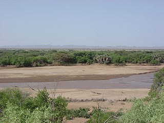
The Kerio River is a river in Turkana County, Kenya. It flows northward into Lake Turkana. It is one of the longest rivers in Kenya, originating near the equator.

<span class="mw-page-title-main">Catholic Church in Kenya</span>

The Catholic Church in Kenya is part of the worldwide Catholic Church, under the spiritual leadership of the Kenyan Conference of Catholic Bishops and the Pope in the Vatican City.

<span class="mw-page-title-main">Turkana people</span> Ethnic group of Eastern Africa

The Turkana are a Nilotic people native to the Turkana County in northwest Kenya, a semi-arid climate region bordering Lake Turkana in the east, Pokot, Rendille and Samburu people to the south, Uganda to the west, to the South Sudan and Ethiopia to the north.

<span class="mw-page-title-main">Lodwar</span> Town in Turkana County, Kenya

Lodwar is the largest town in north-western Kenya, located west of Lake Turkana on the A1 road. Its main industries are basket weaving and tourism. The Loima Hills lie to its west. Lodwar is the capital of Turkana County. The town has a population of 82,970 in 2019.

<span class="mw-page-title-main">Kapenguria</span> Town in Kenya

Kapenguria is a town in Kenya. It is the capital and largest urban center of West Pokot County. The town lies north east of Kitale on the A1 road along Kitale-Lodwar road in north Western Kenya. Kapenguria forms a municipality with a population of 40,751 as per the 2019 Kenya Population and Housing Census.

<span class="mw-page-title-main">Ilemi Triangle</span> Disputed territory between South Sudan and Kenya

The Ilemi Triangle, sometimes called only Ilemi, is a disputed area in East Africa. Arbitrarily defined, it measures about 11,000 square kilometres (4,200 sq mi). The term "Ilemi" may more accurately be transcribed as "Elemi" in the Didinga language, signifying acceptance. This suggest that, in Didinga history, the region became favorable when they arrived, evidenced by the thriving health of the cattle that accepted the local vegetation, indicating a symbiotic relationship between the cattle's well-being and the area. The territory is claimed by South Sudan and Kenya. The territory also borders Ethiopia and, despite use and trespass into the triangle by border tribes from within Ethiopia, the Ethiopian government has not made any official claim on the area, instead agreeing that the land was Sudanese territory in the 1902, 1907, and 1972 treaties.

<span class="mw-page-title-main">West Pokot County</span> County in Kenya

West Pokot County is a county in Kenya. Its capital and largest town is Kapenguria. The county covers an area of approximately 9,169.4 square kilometers and stretches a distance of 132 kilometers from north to south. West Pokot County is bordered to the north by Turkana County, to the east by Baringo County, to the southeast by Elgeyo-Marakwet County, to the south by Trans Nzoia County and to the west by Uganda. According to the 2019 census, the county has a population of 621,241. The county is home to Tegla Loroupe, one of the most famous Kenyan female runners.

<span class="mw-page-title-main">Baringo County</span> County in Kenya

Baringo County is one of the 47 counties in Kenya. It is located in the former Rift Valley Province. Its headquarters and largest town is Kabarnet. The county is home to Lake Baringo, Lake Bogoria and Lake Kamnarok.

Kacheliba Constituency is an electoral constituency in Kenya. It is one of the four constituencies of West Pokot County. The constituency has six wards, which are represented by Members of County Assembly at the West Pokot County Assembly in Kapenguria. The constituency was established before the 1988 elections in order to cater for the interests of the Kara-Pokot community following years of under representation. The constituency was created by the Electoral Commission of Kenya through a publication in the Kenya Gazette.

<span class="mw-page-title-main">Sub-Counties of Kenya</span>

Sub-counties, also known as Districts, are the decentralised units through which government of Kenya provides functions and services. At national level, sub-counties take a more administrative function like security, statistical purposes, provision of government services, etc. Even though the sub-counties are divisions of counties, powers to create new national sub-counties lies with the national government. As of 2023, there are 314 sub-counties, compared to 290 constituencies. A deputy county commissioner is appointed by the state to lead each sub-county. The sub-counties are further divided into divisions, locations and sub-locations.

<span class="mw-page-title-main">Elgeyo-Marakwet County</span> County in Kenya

Elgeyo-Marakwet County is one of Kenya's 47 counties, which is located in the former Rift Valley Province with its capital and largest town as Iten. It borders the counties of West Pokot to the north, Baringo County to the east, southeast and south, Uasin Gishu to the southwest and west, and Trans Nzoia to the northwest.

West Pokot District, formerly known as West Suk or Kacheliba District, was an administrative district in the Rift Valley Province of Kenya. Its capital town was Kapenguria.

<span class="mw-page-title-main">Turkana District</span> Former district of Kenya

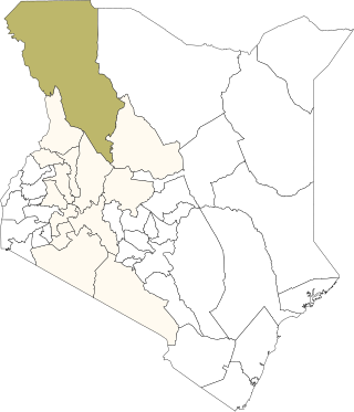
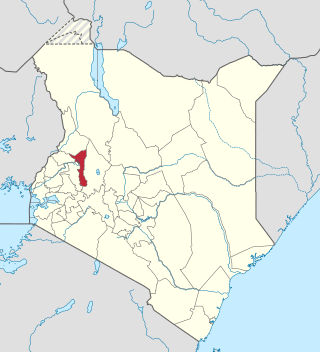
The Turkana District was an administrative district in the Rift Valley Province of Kenya. Turkana was the northwesternmost district in Kenya. It is bordered by the countries of Uganda to the west; South Sudan and Ethiopia, including the disputed Ilemi Triangle, to the north and northeast; and Lake Turkana to the east. To the south and east, neighbouring districts in Kenya are West Pokot, Baringo and Samburu districts, while Marsabit District is located on the opposite shore of Lake Turkana.

Despite its high potential for wind energy generation, wind power in Kenya currently contributes only about 16 percent of the country's total electrical power. However, its share in energy production is increasing. Kenya Vision 2030 aims to generate 2,036 MW of wind power by 2030. To accomplish this goal, Kenya is developing numerous wind power generation centers and continues to rely on the nation's three major wind farms: the Lake Turkana Wind Power Station, the Kipeto Wind Power Station, and the Ngong Hills Wind Farm. While these wind power stations are beneficial to help offset fossil fuel usage and increase overall energy supply reliability in Kenya, project developments have also negatively impacted some indigenous communities and the parts of the environment surrounding the wind farms.

<span class="mw-page-title-main">Aiyangiyang</span> Stone Age archaeological site in Kenya

Aiyangiyang is a basin in southern Turkana, Kenya, southeast of Lodwar. It is known by nomadic pastoralists for its seasonal water availability, and is an important archaeological and paleontological site with artifacts and remains from the African Middle and Late Stone Ages.

<span class="mw-page-title-main">Sengwer people</span>

The Sengwer people are an indigenous community who primarily live in the Embobut forest in the western highlands of Kenya and in scattered pockets across Trans Nzoia, West Pokot and Elgeyo-Marakwet counties. The Sengwer are sometimes portrayed as a component of the Marakwet people but are a distinct ethnic grouping.

Friends of Lake Turkana (FoLT) is a nonprofit organization in Kenya that was founded in 2007 by Kenyan environmentalist Ikal Angelei. The organization has worked to stop the construction of the Ethiopian Gilgel Gibe III Dam on the Omo River, Lake Turkana's primary source of water. Due to FoLT and other partner's advocacy work on saving Lake Turkana, the Lake was added to the list of world Heritage sites in Danger by UNESSCO in June 2018.

The Wajir Museum is a museum located in northeastern Kenya. The museum is in charge of showing the different cultures that inhabit Wajir. The museum is managed by the state-owned National Museums of Kenya Corporation. This is the first museum in Wajir County.

<span class="mw-page-title-main">Ethiopia–Kenya border</span> International border

The Ethiopia–Kenya border was first identified by the United Kingdom in 1907 and refined in 1947 in the aftermath of the East African Campaign of World War II. When Kenya became independent, it was finally approved in 1970. The border stretches 861 kilometers bounded by Marsabit, Turkana, Wajir and Mandera Counties on the side of Kenya, and Borena and Dhawa Zones in the Ethiopian side. The border features enormous biodiversity and wildlife, most notably, several communities such as Mursi, Nyangatom, Daasanach and Turkana, which are agro-pastoralist in response to harsh climate and erratic weather patterns.

References

  1. "2019 Kenya Population and Housing Census Volume I: Population by County and Sub-County". Kenya National Bureau of Statistics. Retrieved 6 November 2019.
  2. B S Blades, B Adams – Lithic Materials and Paleolithic Societies John Wiley & Sons, 12 May 2009 Retrieved 2012-07-08 ISBN   1405168374
  3. C R Ewen -Artifacts Rowman Altamira, 1 April 2003 Retrieved 2012-07-08 ISBN   0759100225
  4. (secondary) D Waugh – Geography: An Integrated Approach ISBN   017444706X Retrieved 1994
  5. Harmand, Sonia; Lewis, Jason E.; Feibel, Craig S.; Lepre, Christopher J.; Prat, Sandrine; Lenoble, Arnaud; Boës, Xavier; Quinn, Rhonda L.; Brenet, Michel (2015). "3.3-million-year-old stone tools from Lomekwi 3, West Turkana, Kenya". Nature. 521 (7552): 310–315. Bibcode:2015Natur.521..310H. doi:10.1038/nature14464. PMID   25993961. S2CID   1207285.
  6. C Ehret, M Posnansky – The Archaeological and Linguistic Reconstruction of African History University of California Press, 1982 Retrieved 2012-07-08 ISBN   0520045939
  7. Lahr, M. Mirazón; Rivera, F.; Power, R. K.; Mounier, A.; Copsey, B.; Crivellaro, F.; Edung, J. E.; Fernandez, J. M. Maillo; Kiarie, C. (2016). "Inter-group violence among early Holocene hunter-gatherers of West Turkana, Kenya". Nature. 529 (7586): 394–398. Bibcode:2016Natur.529..394L. doi:10.1038/nature16477. PMID   26791728. S2CID   4462435.
  8. T G Grenham – The Unknown God: Religious And Theological Interculturation Peter Lang, 2005 Retrieved 2012-07-08 ISBN   3039102613
  9. S Williams – Ian Hodder (ed) – The Archaeology of Contextual Meanings Cambridge University Press, 6 August 1987 Retrieved 2012-07-08 ISBN   0521329248
  10. Merriam-Webster dictionary online
  11. V Broch-Due, R A Schroeder – Producing Nature and Poverty in Africa Nordic Africa Institute, 2000 Retrieved 2012-07-08 ISBN   9171064524
  12. D McNeill, S D Duncan, J Cassell, E T Levy – Gesture and the Dynamic Dimension of Language: Essays in Honor of David McNeill John Benjamins Publishing Company, 2007 Retrieved 2012-07-08 ISBN   9027228418
  13. Traditional Occupations of Indigenous and Tribal Peoples: Emerging Trends International Labour Organization, 2000 Retrieved 2012-07-08
  14. Kenya: Administrative Division population statistics
  15. "2019 Kenya Population and Housing Census Volume IV: Distribution of Population by Socio-Economic Characteristics" (PDF). Kenya National Bureau of Statistics. Retrieved 2 May 2021.
  16. P. H. Gulliver – The Family Herds: A Study of Two Pastoral Tribes in East Africa, the Jie and Turkana Routledge, 31 January 2003 Retrieved 2012-07-08 ISBN   0415176468
  17. NC Dorian – Investigating Obsolescence: Studies in Language Contraction and Death Cambridge University Press, 3 Sep 1992 Retrieved 2012-07-08 ISBN   0521437571
  18. N Middleton, P O'Keefe – Disaster And Development: The Politics of Humanitarian Aid Pluto Press, 20 November 1997 Retrieved 2012-07-08 ISBN   0745312241
  19. W Critchley – Looking After Our Land: Soil and Water Conservation in Dryland Africa p.45- Oxfam, 1991 Retrieved 2012-07-08 ISBN   0855981709
  20. B Calas, CA Mumma Martinon – Shared Waters, Shared Opportunities: Hydropolitics in East Africa African Books Collective, 30 November 2010 Retrieved 2012-07-08 ISBN   9987080928
  21. C Ehret, M Posnansky -
  22. W Critchley
  23. S Boinski, P A Garber – On the Move: How and Why Animals Travel in Groups University of Chicago Press, 15 May 2000 Retrieved 2012-07-08 ISBN   0226063399
  24. "Oil in the cradle of mankind: A glimpse of Africa's future". The Economist . Retrieved 11 July 2015.
  25. "Kenya oil discovery after Tullow Oil drilling". BBC. 26 March 2012. Retrieved 26 March 2012.
  26. Watson, D.J., Binsbergen, J. van – Review of VSF-Belgium's 'Turkana emergency livestock off-take' intervention 2005 ILRI (aka ILCA and ILRAD), 2008 Retrieved 2012-07-08 ISBN   9291462098
  27. Watson, D.J. – Community farmer field school animal health facilitators: hybridizing private animal health care and capacity building in remote pastoralist areas ILRI (aka ILCA and ILRAD) Retrieved 2012-07-08 ISBN   9291462276
  28. P Bonnet – Dromadaires et chameaux, animaux laitiers / Dromedaries and Camels, Milking Animals Editions Quae, 1 January 1998 Retrieved 2012-07-08 ISBN   2876143070
  29. "Strategic groundwater reserves found in Northern Kenya" (news release). UNESCO Media Services. 11 September 2013. Retrieved 12 September 2013.
  30. Nicholas Kulish (11 September 2013). "Huge Aquifers Are Discovered in North Kenya". The New York Times. Retrieved 12 September 2013.
  31. naibuzz.com/2014/05/18/mining-of-water-begins-in-turkana-Kenya/
  32. "Kenya abandons exploration of unviable Turkana water aquifer". 6 February 2022.
  33. "Office of the governor – Turkana County Government" . Retrieved 10 November 2022.
  34. "Cheap flights to Lodwar | Fly540". fly540.com. Retrieved 4 February 2022.
  35. "Lodwar". skywardexpress.co.ke. Retrieved 4 February 2022.
  36. "ECHO Humanitarian Implementation Plan (HIP)" (PDF). European Commission. Retrieved 4 February 2022.