Lamu County

Last updated

Lamu County
Lamu, Lamu Island, Kenya.jpg
Lamu, Lamu Island
Lamu County Flag.png
Lamu County in Kenya.svg
Location in Kenya
CountryFlag of Kenya.svg  Kenya
Formed4 March 2013
Capital Lamu
Government
   Governor Issa Timamy
Area
  Total6,273.1 km2 (2,422.1 sq mi)
  Land6,273.1 km2 (2,422.1 sq mi)
Elevation
110 m (360 ft)
Population
 (2019)
  Total143,920
  Density23/km2 (59/sq mi)
Time zone UTC+3 (EAT)
Website www.lamu.go.ke

Lamu County is a county of Kenya located along the North Coast [1] of the country and is one of the six Coastal Counties [2] in Kenya. Its capital is the town of Lamu. It borders Tana River County to the southwest, Garissa County to the north, Somalia to the northeast, and the Indian Ocean to the South.

Contents

The county has a land surface of 6,273.1 km2 (2,422.1 sq mi), including the mainland [3] and over 65 islands that form the Lamu Archipelago. The total length of the coastline [4] is 130 km (81 mi), while the land water mass [5] area stands at 308 km2 (119 sq mi). [6] As of the 2019 census, Lamu County had a population of 143,920, making it the least populated county in Kenya. [7]

Demographics

The county is made of a cosmopolitan population composed of communities such as Boni, Ormas, Swahilis, Arabs, Koreni, Kikuyu, and other migrant communities from the rest of the country. The county has a total population of 143,920 of which 76,103 are males 67,813 females and 4 intersex persons. There are 37,963 households with an average household size of 3.7 persons per household and a population density of 23 people per square kilometer. [8]

The LAPSSET project is expected to attract a huge migrant population estimated to be over one million. This will certainly overstretch the county's social services necessitating commensurate development planning for adequate service provision. [9]

Historical population
YearPop.±%
1979 42,299    
1989 56,783+34.2%
1999 72,686+28.0%
2009 101,539+39.7%
2019 143,920+41.7%
source: [10]

Religion

   Christian (47%)
   Muslim (51%)
  Other Religions (1%)
  Atheist (1%)

Religion in Lamu County [11]

Administrative and political units

Administrative units

The county has 2 constituencies: Lamu West and Lamu East. These two also consist of the two districts referred to as the sub-counties in Lamu County. [12] Lamu West has Amu Mkomani, Shela, Hindi, Mkunumbi, Hongwe, Bahari and Witu Divisions while Lamu East has Faza, Basuba and Kiunga divisions. There are 10 wards, 23 locations, and 38 sub-locations in the county. [13]

Administrative divisions
DivisionPopulation*Urban pop.*Headquarters
Amu17,31012,839 Lamu
Faza7,4740 Faza
Hindi7,0721,335
Kiunga3,3100 Kiunga
Kizingitini6,0100 Kizingitini
Mpeketoni25,530773 Mpeketoni
Witu5,9801,322 Witu
Total72,68616,269-
* 1999 census. Sources [14] [15]

Political units

There are two constituencies and ten county assembly wards.

ConstituencyCounty wardsLand Area (km2)
LAMU WEST Shella54.7
Mkomani172.5
Hindi1150.8
Mkunumbi1366.1
Hongwe128.5
Bahari123.3
Witu975.4
LAMU EAST Faza79.2
Basuba1708.7
Kiunga513.9
TOTAL6273.1
Source: Lamu County CIDP 2013-2017 [16]
Constituencies

Source [21]

Political leadership

H.E. Issa Abdalla Timamy is the current Governor and is deputized by H.E. Raphael Munyua. H.E. Yasin Twaha was the second Governor and was deputized by H.E. Aboud Bwana Abdulhakim [22] [23] First elected governor for the county was Issa Timamy and was deputized by H.E. Eric Kinyua Mugo. Anuar Loitiptip was the second elected senator after Abu Chiaba.The current Senator is Hon. Joseph Githuka [24] [25] The current Women Representative is Monica Mūthoni Marubu Ruweida Mohamed Obo was the women representative and was elected in 2017, before her was Shakila Abdalla who was elected in 2013. [26] [27]

For Lamu County, the County Executive Committee comprises:-

County Executive Committee
Number
The Governor1
The Deputy Governor1
The County Secretary1
The CEC Members10
Total13

Source [28]

Education

Lamu has 203 ECD centers, 139 primary schools and 25 secondary schools. There are also 58 adult training institutions, 6 vocational training centers as well as 3 universities. [29]

Health

There are a total of 45 health facilities in the county, as well as one county referral hospital. The county has 316 health personnel of different cadre. [30]

HIV prevalence is at 3.5%, compared to the national 5.9%. [31]

Transport and communication

The county is covered by 923.07 km of road network. Of this, 718.66 km is covered by earth surface, 198.41 km is murram surface and 6 km is covered by bitumen.[ when? ] [32] [33]

There are five Post Offices with 1,250 installed letter boxes, 653 rented letter boxes and 597 vacant letter boxes. [34] [35]

Trade and commerce

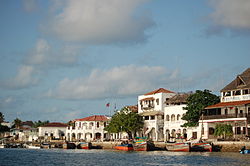
The main economic activities in the county include crop production, livestock production, fisheries, tourism and mining, most notably quarrying. Lamu is rich in minerals like titanium, salt, limestone, coral stones [36] and sand. Lamu town is termed as "the oldest and best-preserved Swahili settlement in East Africa” but neighboring islands also have numerous archaeological remnants of history dating as far back as the 14th Century.

Among the challenges facing Lamu is population growth owing to migration into Lamu from other parts of the country, fueled partly by the anticipated opportunities accruing from the Lamu Port South Sudan-Ethiopia Transport (LAPSSET) Corridor. Other challenges include landlessness and poor land management, insufficient social services such as healthcare and education, inadequate supply of piped and fresh water, under-developed infrastructure, and food insecurity.

There are 9 trading centers, 606 registered businesses, 465 licensed retail traders, 7 supermarkets, 27 licensed wholesale traders and 98 registered hotels. [34]

The county has two National reserves: Dodori, and Kiunga Marine, [37] covering 877 km2. Dodori is a breeding ground for the East Lamu Topi, and consists of a variety of mammals and birdlife including lions, elephant shrew, hippo, pelicans, and many more. It has the most varied species of mangrove forest in Kenya at Dodori Creek. Kiunga Marine Reserve consists of several islands rich with biodiversity including valuable coral reefs, sea grass, extensive mangrove forests, and the endangered sea turtles and dugongs. Kiwayu Island, [38] which is part of the reserve, is deemed as having the most pristine beach in Kenya.

Villages and settlements

See also

Related Research Articles

<span class="mw-page-title-main">President of Kenya</span> Head of state and government of Kenya

The president of the Republic of Kenya is the head of state and head of government of the Republic of Kenya. The president is also the head of the executive branch of the Government of Kenya and is the commander-in-chief of the Kenya Defence Forces. The country's current president is William Ruto since 13 September 2022.

<span class="mw-page-title-main">Meru County</span> County in Kenya

Meru County is one of the 47 counties of Kenya. It borders Isiolo County to the north, Tharaka-Nithi County to the east, Nyeri County to the southwest and Laikipia County to the west. The home of the Meru people, Meru County has a population of 1.55 million people.

<span class="mw-page-title-main">Laikipia County</span> County in Kenya

Laikipia County is one of the 47 Counties of Kenya, located on the Equator in the former Rift Valley Province of the Country. Laikipia is a cosmopolitan County and is Listed as County number 31. The county has two major urban centres: Nanyuki to the southeast, and Nyahururu to the southwest. Its County government headquarters town is Rumuruti. The County lies between latitudes 0° 18" South and 0° 51" North and between longitude 36° 11" and 37° 24' East. It borders Samburu County to the North, Isiolo County to the North East, Meru County to the East, Nyeri County to the South East, Nyandarua County to the South, Nakuru County to the South West and Baringo County to the West.

<span class="mw-page-title-main">Kisumu County</span> County in Kenya

Kisumu County is one of 47 counties in the Republic of Kenya. Its borders follow those of the original Kisumu District, one of the former administrative districts of the former Nyanza Province in western Kenya. Its headquarters is Kisumu City which is the third largest city in Kenya after the capital Nairobi and the coastal city of Mombasa. It has a population of 1,155,574. The land area of Kisumu County totals 2085.9 km2.

<span class="mw-page-title-main">Kericho County</span> County in Kenya

Kericho County is one of the 47 counties in Kenya. The county seats between longitude 35°02' and 35°40' East and between the equator and latitude 0°23' South with an altitude of about 2002m above sea level. It borders Uasin Gishu County to the North West, Baringo County to the North-East, Nandi County to the North-West, Nakuru County to the East and Bomet County to the South, Kisumu County to the Northwest and Nyamira County to the West. It has a population of 901,777 and an area of 2,111 km². Its capital and largest town is Kericho.

<span class="mw-page-title-main">Kakamega County</span> County in Kenya

Kakamega County is a county in the former Western Province of Kenya and borders Vihiga County to the South, Siaya County to the West, Bungoma and Trans Nzoia counties to the North and Nandi and Uasin Gishu counties to the East. Its capital and largest town is Kakamega. It has a population of 1,867,579 and an area of 3,033.8 km2.

<span class="mw-page-title-main">Kilifi County</span> Coastal county in Kenya

Kilifi County was formed in 2010 as a result of a merger of Kilifi District and Malindi District, Kenya. Its capital is Kilifi and its largest town is Malindi. Kilifi county is one of the five counties that make up the Kenyan Coast. The county has a population of 1,453,787 people following the 2019 census which covers an area of 12,245.90 km2 (4,728.17 sq mi).

<span class="mw-page-title-main">Marsabit County</span> County in Kenya

Marsabit County is a county in Kenya. Covering a surface area of 66,923.1 square kilometres. Marsabit is the second largest county by size in Kenya after Turkana county which has an area of 71,597.8 km2. Its capital is Marsabit and its largest town Moyale. According to the 2019 census, the county has a population of 459,785. It is bordered to the North by Ethiopia, to the West by Turkana County to the South by Samburu County and Isiolo County, and to the East by Wajir County.

<span class="mw-page-title-main">Isiolo County</span> County in Kenya

Isiolo County is a county in the former Eastern Province of Kenya. Its population is 268,002 and its capital and largest city is Isiolo. Isiolo County is to be the first county to be developed as part of the Kenya Vision 2030 program. Other upcoming urban centres are: Garbatulla, Modogashe, Kinna, Merti and Oldonyiro.

<span class="mw-page-title-main">Nyamira County</span> County in Kenya

Nyamira County is a county in the former Nyanza Province of Kenya. Formally a district, Nyamira was hived off Kisii District in 1989, and it shares common boundaries with what was known as Nyamira District. The main cash crops grown are bananas and tea. The county has a population of 605,576. Its capital and largest town is Nyamira, with an urban population of around 41,668 The county is also referred to as North Kisii.

<span class="mw-page-title-main">Kajiado County</span> County in Kenya

Kajiado County is a county in the former Rift Valley Province of Kenya. As of 2019, Kajiado county spanned an area of 21,292.7 km2, with a recorded population of 1,117,840. The county borders Nairobi and to its south it borders the Tanzanian regions of Arusha and Kilimanjaro. The county capital is Kajiado, but the largest town is Ongata Rongai. Its main tourist attraction is its wildlife.

<span class="mw-page-title-main">Makueni County</span> County in Kenya

Makueni County is a county in the former Eastern Province of Kenya. Its capital and largest town is Wote. The county has a population of 987,653. The county lies between Latitude 1° 35' and 2° 59' South and Longitude 37° 10' and 38° 30' East. It borders Machakos to the North, Kitui to the East, Taita Taveta to the South and Kajiado to the West and covers an area of 8,008.9 km2.

<span class="mw-page-title-main">Kitui County</span> County in Kenya

Kitui County is a county in the former Eastern Province of Kenya with its capital and largest town being Kitui, although Mwingi is also another major urban centre. The county has a population of 1,136,187. and an area of 30,496 km2. It lies between latitudes 0°10 South and 3°0 South and longitudes 37°50 East and 39°0 East.

<span class="mw-page-title-main">Homa Bay County</span> County in Kenya

Homa Bay County is a county in the former Nyanza Province of Kenya. Its capital and largest town is Homa Bay. The county has a population of 1,131,950 and an area of 3,154.7 km2. Lake Victoria is a major source of livelihood for Homa Bay County. It has 40 wards, each represented by an MCA to the assembly in Homa Bay town as its headquarters.

<span class="mw-page-title-main">Garissa County</span> County in Kenya

Garissa County is an administrative county in Kenya. It is located in Eastern Kenya bordering Somalia to the East, Wajir County and Isiolo County to the North, Tana River County to the West and Lamu County to the South. Its capital and largest urban area is Garissa.

<span class="mw-page-title-main">Mandera County</span> County in Kenya

Mandera County is the northeasternmost county in Kenya. Its capital and largest town is Mandera. The county is bordered by Ethiopia to the north, Somalia to the east and Wajir County to the southwest. According to the 2019 census, the county has a population of 1,200,890 and an area of 25,939.8 square kilometres (10,015.4 sq mi). The main economic activity in the county is pastoralism, while others include cross-border trade with Ethiopia, artisanal mining, beekeeping, and agriculture along the Dawa River.

<span class="mw-page-title-main">Wajir County</span> County in Kenya

Wajir County is a county in the former North Eastern Province of Kenya. Its capital and largest town is Wajir. The county has a population of 781,263 and an area of 55,840.6 km2 (21,560.2 sq mi). The county is bordered to the north by Ethiopia, to the northeast by Mandera County, to the east by Somalia, to the south by Garissa County, to the west by Isiolo County and to the northwest by Marsabit County. The county has six constituencies: Wajir South, Tarbaj, Wajir North, Wajir West, Wajir East, and Eldas.

<span class="mw-page-title-main">Kenya Ports Authority</span> Kenyan government organization

Kenya Ports Authority (KPA) is a state corporation with the responsibility to "maintain, operate, improve and regulate all scheduled seaports" on the Indian Ocean coastline of Kenya, including principally Kilindini Harbour at Mombasa. Other KPA ports include Lamu, Malindi, Kilifi, Mtwapa, Kiunga, Shimoni, Funzi and Vanga.

<span class="mw-page-title-main">Kisii County</span> County in Kenya

Kisii County is a county in the former Nyanza Province in southwestern Kenya. Its capital and largest town is Kisii. The county has a population of 1,266,860 people. It borders Nyamira County to the North East, Narok County to the South, and Homa bay and Migori Counties to the West. The county covers an area of 1,318 km².

<span class="mw-page-title-main">Lamu Port and Lamu-Southern Sudan-Ethiopia Transport Corridor</span>

Lamu Port-South Sudan-Ethiopia-Transport (LAPSSET) Corridor project, also known as Lamu corridor is a transport and infrastructure project in Kenya that, when complete, will be the country's second transport corridor. Kenya's other transport corridor is the Mombasa - Uganda transport corridor that passes through Nairobi and much of the Northern Rift. Some basic LAPSSET infrastructure has been built. The construction of LAPSSET's main components is currently ongoing with construction of the first berth at Lamu Port completed in October, 2019 (situation as per October 2019).. Although the project is not formally stalled, its short to medium term success looks increasingly unlikely. Insecurity and political instability in Kenya are mostly to blame for this, as are more commercially viable alternative pipeline options through Tanzania or Ethiopia. The low oil prices since 2015 also affect LAPSSET's commercial prospects.

References

  1. "Karibu Kenya | North Coast". karibukenya.co.uk. Retrieved 24 October 2022.
  2. "Coast Region | County Trak Kenya" . Retrieved 24 October 2022.
  3. "Mainland", Wikipedia, 22 November 2022, retrieved 24 January 2023
  4. "Coast", Wikipedia, 3 January 2023, retrieved 24 January 2023
  5. "Water mass", Wikipedia, 30 May 2022, retrieved 24 January 2023
  6. Lamu County Integrated Development Plan CIDP 2018-2022. Lamu County Government. 2018. p. 1.
  7. "Kenya", Wikipedia, 19 January 2023, retrieved 24 January 2023
  8. 2019 Kenya Population and House Census: Volume 1- Population by County and Sub-county. Kenya National Bureau of Statistics. 2019. pp. 17, 19, 20. ISBN   9789966102096.
  9. "Brief on LAPSSET Corridor Project 2016" (PDF). LAPSSET Corridor Development Authority. 2016. Retrieved 29 May 2020.
  10. KENYA: Administrative Division population statistics
  11. "2019 Kenya Population and Housing Census Volume IV: Distribution of Population by Socio-Economic Characteristics" (PDF). Kenya National Bureau of Statistics. Retrieved 2 May 2021.
  12. "eLimu | Counties in Kenya". learn.e-limu.org. Retrieved 15 December 2022.
  13. "Ministry of Interior and Coordination of National Government". Ministry of Interior and Coordination of National Government. Retrieved 30 May 2020.
  14. Archived 16 June 2007 at the Wayback Machine
  15. "Urban Poverty All Kenya Provinces". Archived from the original on 18 July 2011. Retrieved 26 May 2014.
  16. "Lamu County CIDP 2013-2017" (PDF). The Council of Governors. Lamu County Government. Retrieved 10 April 2016.
  17. "Hon. Muthama, Stanley Muiruri | The Kenyan Parliament Website". parliament.go.ke. Retrieved 30 May 2020.
  18. "Stanley Muiruri Muthama". Mzalendo. Retrieved 30 May 2020.
  19. "Hon. Ruweida Mohammed Obo | The Kenyan Parliament Website". parliament.go.ke. Retrieved 30 May 2020.
  20. "Shariff Athman Ali". Mzalendo. Retrieved 30 May 2020.
  21. "The Report of the Interim Independent Boundaries Review Commission (IIBRC): Delimitation of Constituencies and Recommendations on Local Authority Electoral Units and Administrative Boundaries for Districts and Other Units" (PDF). IEBC. 2010. Retrieved 29 May 2020.
  22. "Governors & Deputy Governors". cog.go.ke. Retrieved 29 May 2020.
  23. "Yasin Fahim Twaha". Mzalendo. Retrieved 29 May 2020.
  24. "Members of the Senate | The Kenyan Parliament Website". parliament.go.ke. Retrieved 29 May 2020.
  25. "Anwar Loitiptip". Mzalendo. Retrieved 29 May 2020.
  26. "Women Representatives | KEWOPA KENYA" . Retrieved 29 May 2020.
  27. "Ruweida Mohamed Obo". Mzalendo. Retrieved 29 May 2020.
  28. "179. County executive committees – Kenya Law Reform Commission (KLRC)". klrc.go.ke. Retrieved 29 May 2020.
  29. Lamu County Integrated Development Plan CIDP 2018-2022. Lamu County Government. 2018. pp. 37–42.
  30. "CoG Reports". cog.go.ke. Retrieved 29 May 2020.
  31. "Kenya HIV Estimates Report 2018" (PDF). National AIDS Control Council. 2018. Retrieved 30 May 2020.
  32. County Statistical Abstract Lamu County 2015. Kenya National Bureau of Statistics. 2015. p. 33.
  33. "Kenya Rural Roads Authority". Kenya Rural Roads Authority. Retrieved 30 May 2020.
  34. 1 2 "Publications". Kenya National Bureau of Statistics. Retrieved 29 May 2020.
  35. "Home". kura.go.ke. Retrieved 30 May 2020.
  36. "Coral stone – Century Stone". 4 June 2021. Retrieved 24 October 2022.
  37. "Kiunga Marine National Reserve | Kenya Marine Safaris | Kenya Tours". Lake Nakuru National Park. 17 November 2021. Retrieved 24 October 2022.
  38. "Kiwayu Island". Seacology. Retrieved 24 October 2022.

www.lamu.go.ke

2°18′0″S40°42′0″E / 2.30000°S 40.70000°E / -2.30000; 40.70000