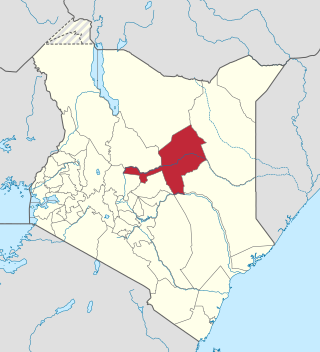
Meru County is one of the 47 counties of Kenya located in the former Eastern Province. It borders Isiolo County to the north, Tharaka-Nithi County to the South, Nyeri County to the southwest and Laikipia County to the west. Meru County has a population of 1.35 million people. It is home to the Meru people.
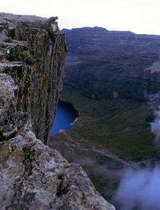
Laikipia County is one of the 47 counties of Kenya, located on the Equator in the former Rift Valley Province of the country. Laikipia is a cosmopolitan county and is listed as county number 31. The county has two major urban centres: Nanyuki to the southeast, and Nyahururu to the southwest. Its county government headquarters town is Rumuruti.

Kisumu County is one of 47 counties in the Republic of Kenya. Its borders follow those of the original Kisumu District, one of the former administrative districts of the former Nyanza Province in western Kenya. Its headquarters is Kisumu City which is the third largest city in Kenya after the capital Nairobi and the coastal city of Mombasa. It has a population of 1,155,574. The land area of Kisumu County totals 2085.9 km2.

Kericho County is one of the 47 counties in Kenya. The county seats between longitude 35°02' and 35°40' East and between the equator and latitude 0°23' South with an altitude of about 2002m above sea level. It borders Uasin Gishu County to the North West, Baringo County to the North-East, Nandi County to the North-West, Nakuru County to the East and Bomet County to the South, Kisumu County to the Northwest and Nyamira County to the West. It has a population of 901,777 and an area of 2,111 km². Its capital and largest town is Kericho.

Kakamega County is a county in the former Western Province of Kenya. It borders Vihiga County to the South, Siaya County to the West, Bungoma and Trans Nzoia counties to the North and Nandi, and Uasin Gishu counties to the East. Its capital and largest town is Kakamega. County has a population of 1,867,579, and an area of 3,033.8 km2.

Lamu County is a county in Kenya located along the North Coast of the country and is one of the six Coastal Counties in Kenya. Its capital is the town of Lamu. It borders Tana River County to the southwest, Garissa County to the north, Somalia to the northeast, and the Indian Ocean to the South. It is the Smallest County in Kenya by population.
Kilifi County was formed in 2010 as a result of a merger of Kilifi District and Malindi District, Kenya. Its capital is Kilifi and its largest town is Malindi. Kilifi county is one of the five counties that make up the Kenyan Coast. The county has a population of 1,453,787 people following the 2019 census which covers an area of 12,245.90 km2 (4,728.17 sq mi).
Marsabit County is a county in Kenya, covering a surface area of 66,923.1 square kilometres. Marsabit is the second largest county by size in Kenya after Turkana county which has an area of 71,597.8 km2. Its capital is Marsabit and its largest town is Moyale. According to the 2019 census, the county has a population of 459,785. It is bordered to the North by Ethiopia, to the West by Turkana County to the South by Samburu County and Isiolo County, and to the East by Wajir County.
Isiolo County is a county in the former Eastern Province of Kenya. Its population is 268,002 and its capital and largest city is Isiolo. Isiolo County is to be the first county to be developed as part of the Kenya Vision 2030 program. Other upcoming urban centres are: Garbatulla, Modogashe, Kinna, Merti and Oldonyiro. The county is home to Sakuye and Borana tribes but also has a significant number of people from Turkana, Samburu, Gabra, Garre and Meru communities.

Kajiado County is a county in the former Rift Valley Province of Kenya. As of 2019, Kajiado county spanned an area of 21,292.7 km2, with a recorded population of 1,117,840. The county borders Nairobi and to its south it borders the Tanzanian regions of Arusha and Kilimanjaro. The county capital is Kajiado, but the largest town is Ongata Rongai. Its main tourist attraction is its wildlife.

Makueni County is a county in the former Eastern Province of Kenya. Its capital town is Wote.The largest town is Wote town followed by Emali town which is also an important market and stop over for the Standard Gauge Railway (SGR). Emali town is multicultural and adds diversity to Makueni county.The county has a population of 987,653. The county lies between Latitude 1° 35' and 2° 59' South and Longitude 37° 10' and 38° 30' East. It borders Machakos County to the North, Kitui County to the East, Taita Taveta County to the South and Kajiado County to the West and covers an area of 8,008.9 km2.

Kitui County is one of the 47 counties of Kenya in the former Eastern Province of Kenya. Its capital and largest town is Kitui, and Mwingi is also another major urban centre. The county has a population of 1.2 million people and an area of 30,496 km2. It lies between latitudes 0°10 South and 3°0 South and longitudes 37°50 East and 39°0 East.
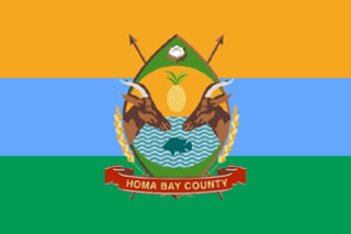
Homa Bay County is a county in the former Nyanza Province of Kenya. Its capital and largest town is Homa Bay. The county has a population of 1,131,950 and an area of 3,154.7 km2. Lake Victoria is a major source of livelihood for Homa Bay County. It has 40 wards, each represented by an MCA in the Homa Bay county assembly located in Homa Bay town, which is the county headquarters.
Mandera County is a county in northeastern Kenya, bordering Ethiopia to the north, Somali to the east, and Wajir to the south. It is predominantly home to the Somali community, with a population of 983,000 (2024), making it the 28th largest county in Kenya. Covering an area of approximately 25,797 square kilometers, Mandera County features natural landscapes, including the Dawa River and vast deserts.

Bomet County is located in the Rift Valley region of Kenya, was established in 2010 and has a population of approximately 875,689[¹], making it the 32nd largest county in Kenya by population. It is bordered by Kericho County to the west, Nakuru County to the northwest, and Narok County to the southeast. The county is characterized by its rolling hills, fertile agricultural land, and significant natural features, including the Mau Forest and rivers such as Nyangores and Chepalungu. The predominant ethnic group is the Kalenjin, known for their rich cultural heritage and agricultural practices.
North Mugirango is one of four constituencies in Nyamira County. In 1966 the North Mugirango Constituency was split into West Mugirango and a smaller North Mugirango. The name was changed to Borabu / North Mugirango Constituency in 1974. In 1987 the name changed back to North Mugirango. Prior to 2013, it was formally known as North Mugirango (Borabu) Constituency after which Borabu constituency was hived out hence its reversion to the name Mugirango Constituency again.

Kisii County is a county in the former Nyanza Province in southwestern Kenya. Its capital and largest town is Kisii. The county has a population of 1,266,860 people. It borders Nyamira County to the North East, Narok County to the South, and Homa bay and Migori Counties to the West. The county covers an area of 1,318 km2.
Nyamira District was an administrative district in the Nyanza Province of Kenya. It was split from Kisii District in 1989 and was sometimes referred to as North Kisii District. The district had a population of 492,102. Its capital town was Nyamira.
Borabu is a constituency in Kenya. It is one of the four constituencies in Nyamira County. It was established prior to the 2013 general elections. It was initially part of North Mugirango/Borabu Constituency.
Nyagarama, formally known as John Obiero Nyagarama, was a Kenyan politician. He was the first Governor of Nyamira County, deputised by Amos Nyaribo. He was a member of the Orange Democratic Movement and was elected in March 2013, subsequently retaining his seat for a second term beginning August 2017.

