Related Research Articles

Kericho County is one of the 47 counties in Kenya. The county seats between longitude 35°02' and 35°40' East and between the equator and latitude 0°23' South with an altitude of about 2002m above sea level. It borders Uasin Gishu County to the North West, Baringo County to the North-East, Nandi County to the North-West, Nakuru County to the East and Bomet County to the South, Kisumu County to the Northwest and Nyamira County to the West. It has a population of 901,777 and an area of 2,111 km². Its capital and largest town is Kericho.

Narok County is a county in southwestern Kenya with an estimated population of 1,157,873 according to 2019 Census. The dominant ethnic group is the Maasai. Its capital and largest town is Narok, with the only other major urban centre being Kilgoris. Narok County Government was formed by the County Governments Act of 2012 as prescribed in the 2010 Constitution of Kenya. Narok County governor is Patrick Ole Ntutu after winning in the 2022 elections and his Deputy is Tamalinye K. Koech.

Kiambu County is a county in the former Central Province of Kenya. Its capital is Kiambu and its largest town is Thika town. Kiambu County is the second most populous county in Kenya after Nairobi County. Kiambu County borders Nairobi and Kajiado Counties to the South, Machakos to the East, Murang'a to the North and North East, Nyandarua to the North West, and Nakuru to the West. It has a population of 2,417,735.

Taita–Taveta County is a county in Kenya. Located approximately 200 km northwest of Mombasa, and 360 km southeast of Nairobi, it is a port and major gateway to the United Republic of Tanzania through Taveta. The county headquarters are located in Mwatate. It is one of the six counties in the Coastal region of Kenya. Major towns include Voi, Taveta, Mwatate, and Wundanyi.

Nyamira County is a county in the former Nyanza Province of Kenya. Formally a district, Nyamira was hived off Kisii District in 1989, and it shares common boundaries with what was known as Nyamira District. The main cash crops grown are bananas and tea. The county has a population of 605,576. Its capital and largest town is Nyamira, with an urban population of around 41,668 The county is also referred to as North Kisii.
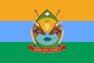
Homa Bay County is a county in the former Nyanza Province of Kenya. Its capital and largest town is Homa Bay. The county has a population of 1,131,950 and an area of 3,154.7 km2. Lake Victoria is a major source of livelihood for Homa Bay County. It has 40 wards, each represented by an MCA in the Homa Bay county assembly located in Homa Bay town, which is the county headquarters.
Kitutu Masaba is an electoral constituency in Kenya. It was known as Kitutu East Constituency from 1963 to 1988. It is one of four constituencies of Nyamira County. The constituency renamed to Kitutu Masaba prior to the 1988 elections.
Cherangany Constituency, comprises the larger Trans Nzoia East District; otherwise known as Cherangani Sub-County, with an approximate area of 556.9 square km. It is an electoral constituency in Kenya, which was established/created for the 1988 general election.
Bonchari is an electoral constituency in Kisii County. It is one of nine constituencies in the county. The constituency was established for the 1988 elections. It has four wards namely; Riana, Bomorenda, Bomariba and Bogiakumu.
North Mugirango is one of four constituencies in Nyamira County. In 1966 the North Mugirango Constituency was split into West Mugirango and a smaller North Mugirango. The name was changed to Borabu / North Mugirango Constituency in 1974. In 1987 the name changed back to North Mugirango. Prior to 2013, it was formally known as North Mugirango (Borabu) Constituency after which Borabu constituency was hived out hence its reversion to the name Mugirango Constituency again.

Kisii County is a county in the former Nyanza Province in southwestern Kenya. Its capital and largest town is Kisii. The county has a population of 1,266,860 people. It borders Nyamira County to the North East, Narok County to the South, and Homa bay and Migori Counties to the West. The county covers an area of 1,318 km2.
West Mugirango Constituency is an electoral constituency in Kenya. It is one of four constituencies of Nyamira County. The constituency was established for the 1966 elections from what was a larger North Mugirango Constituency.

Keroka is a town located in Kenya's Nyamira and Kisii counties. It is the largest town in Nyamira county after Nyamira Town.

Nairobi City County is one of the 47 counties of Kenya. With an estimated population of 5,454,000 in 2024, it is the third-smallest in area of the counties, yet the most populous one. It also serves as the capital of Kenya. The county entity was effected in 2013, replacing Nairobi City Council, which had been the long-standing unit of local administration since before Kenya's independence. The city county consists of eleven gazetted sub-counties and eighty-five electoral wards. On the national level, Nairobi also sends seventeen Members of Parliament across the constituencies and one County Woman Representative to the National Assembly; and one senator to the Senate. The county government, which is allotted devolved functions as stated in the Constitution of Kenya, is headed by the county governor, who appoints his cabinet. The county's legislature is headed by the County Speaker, who presides over the County Assembly. The Members of the County Assembly (MCAs) are elected from single-member districts and represent their respective electoral wards. Additional MCAs are also nominated by political parties as a form of affirmative action.

Sub-counties, also known as Districts, are the decentralised units through which government of Kenya provides functions and services. At national level, sub-counties take a more administrative function like security, statistical purposes, provision of government services, etc. Even though the sub-counties are divisions of counties, powers to create new national sub-counties lies with the national government. As of 2023, there are 314 sub-counties, compared to 290 constituencies. A deputy county commissioner is appointed by the state to lead each sub-county. The sub-counties are further divided into divisions, locations and sub-locations.
Nyamira District was an administrative district in the Nyanza Province of Kenya. It was split from Kisii District in 1989 and was sometimes referred to as North Kisii District. The district had a population of 492,102. Its capital town was Nyamira.
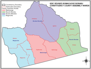
Bomachoge Borabu is a constituency in Kenya. It is one of nine constituencies in Kisii County. The constituency was hived off from the former Bomachoge constituency and it was established for the 2013 general elections.
Embakasi North is a constituency in Kenya and one of the seventeen constituencies in Nairobi County. Embakasi North includes five electoral wards: Kariobangi North, Dandora Area I, Dandora Area II, Dandora Area III, and Dandora Area IV. The constituency has an area of 5.50 km2 (2.1 sq mi). It was created prior to the 2013 election when Kasarani Constituency and Embakasi Constituency boundaries were revised. The constituency forms part of two sub-counties of Nairobi; Kariobangi North falls under Kasarani while the Dandora area is in Njiru.
Mathare is a constituency in Nairobi. It is one of seventeen constituencies in Nairobi City County. It was created prior to the 2013 general election, when Starehe Constituency boundaries were revised. It is the smallest constituency in Nairobi with an area of 3.00 km2 (1.2 sq mi). It borders Ruaraka Constituency to the north; Roysambu and Westlands constituencies to the northwest; Embakasi Central Constituency to the east; Kamukunji Constituency to the south; and Starehe Constituency to the west.
Nyagarama, formally known as John Obiero Nyagarama, was a Kenyan politician. He was the first Governor of Nyamira County, deputised by Amos Nyaribo. He was a member of the Orange Democratic Movement and was elected in March 2013, subsequently retaining his seat for a second term beginning August 2017.
References
- ↑ "Constituency – Constituencies in Kenya". softkenya. Archived from the original on July 10, 2017. Retrieved 9 June 2018.
{{cite web}}: CS1 maint: unfit URL (link) - ↑ "Constituencies". The National Government Constituencies Development Fund (NG-CDF). Archived from the original on 2018-06-12. Retrieved 9 June 2018.
- ↑ "COUNTY WARDS". County Assembly of Nyamira. Retrieved 8 November 2022.
- ↑ "COUNTY WARDS". County Government of Nyamira. Retrieved 8 November 2022.
- ↑ "County Governments Act No. 17 of 2012" (PDF). Law Society of Kenya. p. 39. Retrieved 4 November 2022.
| | This Kenya location article is a stub. You can help Wikipedia by expanding it. |
Polycap orangi orambui