Related Research Articles
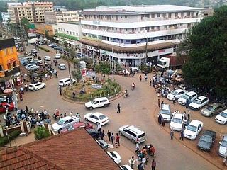
Kisii is a municipality and urban centre in south-western Kenya and the capital of Kisii County. Kisii Town also serves as a major urban and commercial centre in the Gusii Highlands—Kisii and Nyamira counties—and the South Nyanza region and is the second largest town in formerly greater Nyanza after Kisumu City. Kisii municipality sits right at the centre of the western Kenya tourist circuit that includes the Tabaka Soapstone Carvings, Maasai Mara, Ruma National Park and part of the Lake Victoria Basin.

Kericho County is one of the 47 counties in Kenya. The county seats between longitude 35°02' and 35°40' East and between the equator and latitude 0°23' South with an altitude of about 2002m above sea level. It borders Uasin Gishu County to the North West, Baringo County to the North-East, Nandi County to the North-West, Nakuru County to the East and Bomet County to the South, Kisumu County to the Northwest and Nyamira County to the West. It has a population of 901,777 and an area of 2,111 km². Its capital and largest town is Kericho.

Narok County is a county in southwestern Kenya with an estimated population of 1,157,873 according to 2019 Census. The dominant ethnic group is the Maasai. Its capital and largest town is Narok, with the only other major urban centre being Kilgoris. Narok County Government was formed by the County Governments Act of 2012 as prescribed in the 2010 Constitution of Kenya. Narok County governor is Patrick Ole Ntutu after winning in the 2022 elections and his Deputy is Tamalinye K. Koech.
Gucha District was a former district in Nyanza Province, western Kenya. It was also known as South Kisii District or Ogembo District. In 1999, its population was approximately 461,000 people. Its district headquarters were at Ogembo which houses more than a thousand residents,, with more than one thousand people more that visit it each day.

Nyamira County is a county in the former Nyanza Province of Kenya. Formally a district, Nyamira was hived off Kisii District in 1989, and it shares common boundaries with what was known as Nyamira District. The main cash crops grown are bananas and tea. The county has a population of 605,576. Its capital and largest town is Nyamira, with an urban population of around 41,668 The county is also referred to as North Kisii.
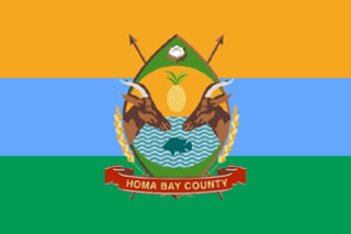
Homa Bay County is a county in the former Nyanza Province of Kenya. Its capital and largest town is Homa Bay. The county has a population of 1,131,950 and an area of 3,154.7 km2. Lake Victoria is a major source of livelihood for Homa Bay County. It has 40 wards, each represented by an MCA in the Homa Bay county assembly located in Homa Bay town, which is the county headquarters.
Kuria District was an administrative district in the Nyanza Province of Kenya. Its capital town is Kehancha. The district has a population of 256,086 and an area of 581/km2. It is inhabited by a minority group of people fondly known as Kuria people, also referred to as Abakuria (Mkuria/Wakuria) in Swahili. They are scattered across the Kenya-Tanzania border, and are neighbors to the Kisii, Luo and Maasai people.
Nyamira is a town in Kenya. It is the capital of its Nyamira County. It has an urban population of around 10.000 . The main government hospital is Nyamira District Hospital with a bed capacity of 203.
Oyugis is the second-largest town in Homa Bay County in Nyanza Kenya. The town lies along the Kisumu-Kisii highway. It is the commercial and financial centre of Rachuonyo Sub-County in Homa Bay County of the former Nyanza Province.
South Mugirango is an electoral constituency in Kenya. It is one of nine constituencies in Kisii County. The constituency was established for the 1992 elections.
North Mugirango is one of four constituencies in Nyamira County. In 1966 the North Mugirango Constituency was split into West Mugirango and a smaller North Mugirango. The name was changed to Borabu / North Mugirango Constituency in 1974. In 1987 the name changed back to North Mugirango. Prior to 2013, it was formally known as North Mugirango (Borabu) Constituency.

Kisii County is a county in the former Nyanza Province in southwestern Kenya. Its capital and largest town is Kisii. The county has a population of 1,266,860 people. It borders Nyamira County to the North East, Narok County to the South, and Homa bay and Migori Counties to the West. The county covers an area of 1,318 km².
West Mugirango Constituency is an electoral constituency in Kenya. It is one of four constituencies of Nyamira County. The constituency was established for the 1966 elections from what was a larger North Mugirango Constituency.
Bonyunyu is a settlement in Kenya's Nyanza Province. Bonyunyu market is found in Boisanga sublocation, Itibo ward, Nyamira north district, North mugirango constituency The market was founded in earlier 1994 but it boomed at around 2015 due to the opening of Ekerubo Gietai institute.. The village is inhabited by majority of Abagusii people of Mugirango Clan, Bomorendi and Kibaru sub clans. Other clans from neighboring regions of Bosaragei, Bonyakoni are moving in to complement the population. Other Kenyan tribes such as Luo, Luyha and Maasai are coming to supplement their culture due to students population who comes from different parts of the country. The social economic features of the village include farming, brick making, tea farming, dairy farming, business among other small scale activities. The mode of transportation is mainly by Boda Boda. The village has good network of roads but still remains murramed.
Kuresoi Constituency was one of the five constituencies in Nakuru County, in the Rift valley province. Kenya. In 2012, Kuresoi district was split into two constituencies; Kuresoi North and Kuresoi South. A large part of kuresoi is the East Mau forest, part of the largest water catchment in Kenya, Mau forest. Two major rivers, Mara River and Sondu Miriu have their sources in Kuresoi, Molo River which drains into Lake Baringo has one of its tributaries Ribeti starting in Kuresoi.

Sub-counties, also known as Districts, are the decentralised units through which government of Kenya provides functions and services. At national level, sub-counties take a more administrative function like security, statistical purposes, provision of government services, etc. Even though the sub-counties are divisions of counties, powers to create new national sub-counties lies with the national government. As of 2023, there are 314 sub-counties, compared to 290 constituencies. A deputy county commissioner is appointed by the state to lead each sub-county. The sub-counties are further divided into divisions, locations and sub-locations.
Kisii University is a public university located in Kisii. It was founded in 1965 as a primary teachers’ training college on a 61-acre land that was donated by the County Council of Gusii. The college continued up to 1983 when it was upgraded to a secondary teachers’ college to offer Diploma programmes.
Nandi District was an administrative district in the Rift Valley Province of Kenya. Its capital town was Kapsabet.
Kisii District was a district in the Nyanza Province in southwestern Kenya. Its capital town was Kisii. The district was created during the colonial period from the South Kavirondo District. The district is inhabited mostly by the Gusii people. Nyamira District was later carved out of Kisii in 1989. Further splitting led to the creation of Kisii Central District and Gucha District. In 2013, the district's former boundaries, except Nyamira District, were effected again to form Kisii County.
Nyagarama, formally known as John Obiero Nyagarama, was a Kenyan politician. He was the first Governor of Nyamira County, deputised by Amos Nyaribo. He was a member of the Orange Democratic Movement and was elected in March 2013, subsequently retaining his seat for a second term beginning August 2017.
References
- ↑ "46 Districts of 1993". Ustawi. 25 September 2015. Retrieved 17 October 2023.
- 1 2 "Kenya Districts". www.statoids.com. Retrieved 2023-09-22.
- 1 2 "The 2009 Kenya Population and Housing Census" (PDF). Amazonaws. p. 139. Retrieved 11 October 2023.