Related Research Articles

Eldoret is the fifth largest city in Kenya. It is located in the Rift Valley region and serves as the capital of Uasin Gishu County. The town was referred to by white settlers as Farm 64 and colloquially by locals as 'Sisibo'. As per the 2019 Kenya Population and Housing Census, Eldoret is the fifth most populated urban area in the country after Nairobi, Mombasa, Nakuru and Ruiru. Lying south of the Cherangani Hills, the local elevation varies from about 2,100 metres (6,900 ft) at the airport to more than 2,700 metres (8,900 ft) in nearby areas. The population was 289,380 in the 2009 Census, and it is currently the fastest growing town in Kenya with 475,716 people according to 2019 National Census. Eldoret was on course to be named Kenya's fourth city, but was edged out by Nakuru in 2021.

Kitale is an agricultural town in the northern Rift Valley, situated between Mount Elgon and the Cherangany Hills.The town has an elevation of around 1,900 metres (6,200 ft) Its population is 162,174 as of 2019. Kitale is the headquarter town of Trans-Nzoia County. Kitale is reachable by air through Kitale Airport. The postal code for Kitale is 30200.

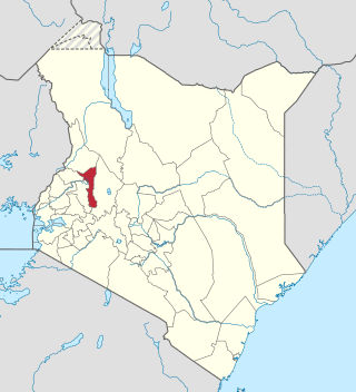
Trans-Nzoia County is a county in the former Rift Valley Province, Kenya, located between the Nzoia River and Mount Elgon, 380 km northwest of Nairobi. At its centre is the town of Kitale which is the capital and largest town. The county borders Bungoma to the west, Uasin Gishu and Kakamega to the south, Elgeyo-Marakwet to the east, West Pokot to the north and the republic of Uganda to the Northwest. Trans Nzoia covers an area of 2495.5 square kilometres.

Bridgeport is a census-designated place (CDP) and unincorporated community that is part of Logan Township, in Gloucester County, in the U.S. state of New Jersey. At the 2020 United States census, the population of the CDP was 389. in the 2010 census, the population was 504.

Murang'a County is one of the counties of Kenya's former Central Province. Its largest town and capital is Murang'a, which was referred to as Fort Hall during the colonial era. The county is inhabited mainly by and is considered the birthplace of the Gikuyu, the largest ethnic group in Kenya. The county has a population of 1,056,640 based on the 2019 census.

Uasin Gishu County is one of the 47 counties of Kenya located in the former Rift Valley Province. Eldoret has the county's largest population centre as well as its administrative and commercial centre. "It lies between longitudes 34 degrees 50' east and 35 degrees 37' West and latitudes 0 degrees 03' South and 0 degrees 55' North. It is a highland plateau with altitudes falling gently from 2,700 meters above sea level to about 1,500 meters above sea level. The topography is higher to the east and declines gently towards the western border".

Nakuru is a city in the Rift Valley region of Kenya. It is the capital of Nakuru County, and is the third largest city in Kenya. As of 2019, Nakuru has an urban population of 570,674, making it the largest urban centre in the Rift Valley, succeeding Eldoret, Uasin Gishu County. The city lies along the Nairobi–Nakuru Highway, 160 kilometres (99 mi) from Nairobi.

Kericho is the biggest town in Kericho County located in the highlands west of the Kenyan Rift Valley. Standing on the edge of the Mau Forest, Kericho has a warm and temperate climate making it an ideal location for agriculture and in particular, the large scale cultivation of tea.

Machakos, also called Masaku, is a town in Machakos County, Kenya. Serving as the capital of the county, its urban population was 63,767 as of 2019.
Kapenguria is a town in Kenya. It is the capital and largest urban center of West Pokot County. The town lies north east of Kitale on the A1 road along Kitale-Lodwar road in north Western Kenya. Kapenguria forms a municipality with a population of 40,751 as per the 2019 Kenya Population and Housing Census.
Kapsabet is a town in Kenya. It is the capital of Nandi County and is located 40 kilometres southwest of Eldoret on the way to Chavakali.

Baringo County is one of the 47 counties in Kenya. It is located in the former Rift Valley Province. Its headquarters and largest town is Kabarnet. The county is home to Lake Baringo, Lake Bogoria and Lake Kamnarok.
Kaptagat is a human settlement in Uasin Gishu County, in the southwestern part of Kenya. This part of the country, where the two counties of Uasin Gishu and Elgeyo Marakwet County share a border, is used by the majority of Kenyan professional long-distance runners to train for professional competition. Eliud Kipchoge, the former marathon world record holder, who also doubles as the Tokyo Olympics and Rio Olympics marathon gold medalist, maintains a training camp in Kaptagat.

Githurai is a composition of densely populated, urban, mixed-use settlements located at the border of Nairobi County and Kiambu County along the Thika Road. Githurai is divided into two; Githurai 45 and Githurai 44. Githurai 45 falls under Ruiru Constituency in the Githurai Sub-county of Kiambu County with the boundary being the Thika Road reserve and River Kasarani downstream. Githurai 44 is domiciled in Roysambu Constituency in the Kasarani Sub-county of Nairobi County. Githurai 44 neighbours Kahawa West, Zimmerman and Njatha-ini Village.
Elgeyo-Marakwet County is one of Kenya's 47 counties, which is located in the former Rift Valley Province with its capital and largest town as Iten. It borders the counties of West Pokot to the north, Baringo County to the east, southeast and south, Uasin Gishu to the southwest and west, and Trans Nzoia to the northwest.
Uasin Gishu District, also known as Eldoret District, was one of the districts of Kenya, located in the Rift Valley Province. The town of Eldoret was its capital, administrative and commercial centre. It bordered the Trans-Nzoia District.
Rift Valley Technical Training institute (RVTTI) is a public technical training institute located in the highland city of Eldoret, Kenya. It is one of the Technical Training Institutes in Kenya. The institution offers Artisan, Craft, Diploma and Higher Diploma Courses with bias to practical industrial applications.
Alten Solar Power Station, also Kesses 1 Solar Power Station, is a 44 megawatts (59,000 hp) solar power plant in Kenya, the largest economy in the East African Community.
The Nairobi–Nakuru–Mau Summit Highway is a road in Kenya, connecting the capital city of Nairobi, in Nairobi County, with the towns of Naivasha, Nakuru and Mau Summit, in Nakuru County.
References
- ↑ Kenya National Bureau of Statistics (December 2019). 2019 Kenya Population and Housing Census; Volume II: Distribution of Population by Administrative Units (Report). Kenya National Bureau of Statistics. p. 147. Retrieved 16 April 2023.
- ↑ "Dataset records: Postal codes". mapanet.eu. Mapnet. Retrieved 16 April 2023.
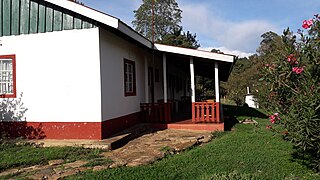
Locality: Ollessos Postcode: 30314
- ↑ "Ollessos Technical Training Institute". otti.ac.ke. Ollessos Technical Training Institute. 2023. Retrieved 16 April 2023.
- ↑ "Kenya Storage Assessment". logcluster.org. World Food Programme. Retrieved 16 April 2023.
- ↑ Too, Titus. "Milk farmers who supply KCC cry foul over falling prices of commodity". The Standard. Rift Valley. Retrieved 16 April 2023.
- ↑ "Access Bank: Branch & ATM Locator". kenya.accessbankplc.com. Access Bank. Retrieved 16 April 2023.