This article is about the transport in Zambia.

Lake Mweru is a freshwater lake on the longest arm of Africa's second-longest river, the Congo. Located on the border between Zambia and Democratic Republic of the Congo, it makes up 110 kilometres (68 mi) of the total length of the Congo, lying between its Luapula River (upstream) and Luvua River (downstream) segments.
This article deals with the disputed area on the borders of the Democratic Republic of the Congo and Zambia, in Luapula Province.

Bangweulu — 'where the water sky meets the sky' — is one of the world's great wetland systems, comprising Lake Bangweulu, the Bangweulu Swamps and the Bangweulu Flats or floodplain. Situated in the upper Congo River basin in Zambia, the Bangweulu system covers an almost completely flat area roughly the size of Connecticut or East Anglia, at an elevation of 1,140 m straddling Zambia's Luapula Province and Northern Province. It is crucial to the economy and biodiversity of northern Zambia, and to the birdlife of a much larger region, and faces environmental stress and conservation issues.

The Luapula River is a section of Africa's second-longest river, the Congo. It is a transnational river forming for nearly all its length part of the border between Zambia and the DR Congo. It joins Lake Bangweulu to Lake Mweru and gives its name to the Luapula Province of Zambia.

The Kafue River is the longest river lying wholly within Zambia at about 1,576 kilometres (979 mi) long. Its water is used for irrigation and for hydroelectric power. It is the largest tributary of the Zambezi, and of Zambia's principal rivers, it is the most central and the most urban. More than 50% of Zambia's population live in the Kafue River Basin and of these around 65% are urban.
Mbala is Zambia’s most northerly large town and seat of Mbala District, occupying a strategic location close to the border with Tanzania and controlling the southern approaches to Lake Tanganyika, 40 km by road to the north-west, where the port of Mpulungu is located. It had a population of about 20,000 in 2006. Under the name Abercorn, Mbala was a key outpost in British colonial control of this part of south-central Africa. It is headquarters of an administrative district of the Northern Province.

Northern Province is one of Zambia's ten provinces. It covers approximately one sixth of Zambia in land area. The provincial capital is Kasama. The province is made up of 12 districts, namely Kasama District, Chilubi District, Kaputa District, Luwingu District, Mbala District, Mporokoso District, Mpulungu District, Mungwi District, Nsama District, Lupososhi District, Lunte District and Senga Hill District. Currently, only Kasama and Mbala have attained municipal council status, while the rest are still district councils. It is widely considered to be the heartland of the Bemba, one of the largest tribes in Zambia.

The Kalungwishi River flows west in northern Zambia into Lake Mweru. It is known for its waterfalls, including the Lumangwe Falls, Kabweluma Falls, Kundabwika Falls and Mumbuluma Falls.
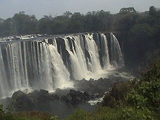
Lumangwe Falls on the Kalungwishi River in northern Zambia is the largest waterfall wholly within the country, with a height of 30-40 m and a width of 100-160 m. It is a block-type waterfall located between the Luapula and Northern Provinces. The main bedrock is interbedded quartzite with layers of red siltstone.
A dambo is a class of complex shallow wetlands in central, southern and eastern Africa, particularly in Zambia and Zimbabwe. They are generally found in higher rainfall flat plateau areas and have river-like branching forms which in themselves are not very large but combined add up to a large area. Dambos have been estimated to comprise 12.5% of the area of Zambia. Similar African words include mbuga, matoro (Mashonaland), vlei, fadama (Nigeria), and bolis ; the French bas-fond and German Spültal have also been suggested as referring to similar grassy wetlands.
Water transport and the many navigable inland waterways in Zambia have a long tradition of practical use except in parts of the south. Since draught animals such as oxen were not heavily used, water transport was usually the only alternative to going on foot until the 19th Century. The history and current importance of Zambian waterways, as well as the types of indigenous boats used, provide information on this important aspect of Zambian economy.

Chiengi or Chienghospital historic colonial boma of the British Empire in central Africa and today is a settlement in the Luapula Province of Zambia, and headquarters of Chiengi District. Chiengi is in the north-east corner of Lake Mweru, and at the foot of wooded hills dividing that lake from Lake Mweru Wantipa, and overlooking a dambo stretching northwards from the lake, where the Chiengi rivulet flows down from the hills.

The wildlife of Zambia refers to the natural flora and fauna of Zambia. This article provides an overview, and outline of the main wildlife areas or regions, and compact lists of animals focusing on prevalence and distribution in the country rather than on taxonomy. More specialized articles on particular groups are linked from here.

The Zambezian flooded grasslands is an ecoregion of southern and eastern Africa that is rich in wildlife.

The climate of Zambia in Central and Southern Africa is definitely tropical modified by altitude (elevation). In the Köppen climate classification, most of the country is classified as humid subtropical or tropical wet and dry, with small patches of semi-arid steppe climate in the south-west.
The biomes and ecoregions in the ecology of Zambia are described, listed and mapped here, following the World Wildlife Fund's classification scheme for terrestrial ecoregions, and the WWF freshwater ecoregion classification for rivers, lakes and wetlands. Zambia is in the Zambezian region of the Afrotropical biogeographic realm. Three terrestrial biomes are well represented in the country . The distribution of the biomes and ecoregions is governed mainly by the physical environment, especially climate.

The following outline is provided as an overview of and topical guide to Zambia:
Zambia, officially known as the Republic of Zambia, is a landlocked country in Southern Africa. The neighbouring countries are the Democratic Republic of the Congo to the north, Tanzania to the north-east, Malawi to the east, Mozambique, Zimbabwe, Botswana, and Namibia to the south, and Angola to the west. The capital city is Lusaka, located in the southeast of the country. The population is concentrated mainly around the capital and the Copperbelt to the northwest.

Chiengi District with headquarters at Chiengi is the smallest and most northerly district in the Luapula Province of Zambia and was carved out of Nchelenge District after Zambia's independence. As of the 2010 Zambian Census, the district had a population of 109,147 people. Most of its population live in fishing villages along the 70 km (approx.) of the north-east shore of Lake Mweru which lies within the district. The largest settlement is Puta, 5 km south of Chiengi town, named after Chief Puta. The district is bounded by the DR Congo border in the north, Kaputa District in the east and the Kalungwishi River in the south.


