Fauna
Even during the dry season, the floodplains sustain a great deal of wildlife including grazing African buffalo, wildebeest, and elephants, zebras, and giraffes, as well as hippopotamus and crocodiles in the waters. There are many antelopes such as waterbucks, pukus, elands, and lechwe, the Bangwelu Swamp in particular is home to black lechwe (Kobus leche smithermani), tsessebe, and sitatunga while the Kafue Flats have large groups of Kafue lechwe and Burchell's zebra.
The large numbers of birds, especially waterbirds, in the floodplains include saddle-billed storks. There are two endemic reptiles; the Merara toad ( Amietophrynus reesi ) in the Kilombero valley, and the Barotse water snake (Crotaphopeltis barotseensis).
Threats and preservation
Despite the tsetse fly and the swampy water the floodplains have long been home to rural communities, such as the Lozi people in the Barotse Floodplain and the Tonga in the Kafue Flats, but are mostly unspoilt and large areas are protected. However, wildlife is still vulnerable to poaching and illegal farming or grazing of livestock. Meanwhile as the population in this part of Africa is continually growing demand for water and farmland places the floodplains under constant threat as land is polluted or farmed, grassland set on fire and rivers are dammed or diverted. The Kafue Flats have been drastically changed by the damming of the river and similar projects are planned for the Okavango.
Protected areas include the Okavango Delta, the Bangweulu, Moyowosi and Kilombero swamps and the Kafue Flats and in addition Lake Chilwa is a Ramsar birding area. Of these Okavango is the largest and best-known, being mostly within the Moremi Game Reserve, having spectacular wildlife and a well-developed safari industry based in the town of Maun. In Zambia Lochinvar and Blue Lagoon National Parks are protected.
This article is about the Transport in Zambia.

The Zambezi is the fourth-longest river in Africa, the longest east-flowing river in Africa and the largest flowing into the Indian Ocean from Africa. Its drainage basin covers 1,390,000 km2 (540,000 sq mi), slightly less than half of the Nile's. The 2,574 km (1,599 mi) river rises in Zambia and flows through eastern Angola, along the north-eastern border of Namibia and the northern border of Botswana, then along the border between Zambia and Zimbabwe to Mozambique, where it crosses the country to empty into the Indian Ocean.
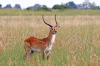
The lechwe, red lechwe, or southern lechwe is an antelope found in wetlands of south-central Africa.

The Kafue River is the longest river lying wholly within Zambia at about 1,576 kilometres (979 mi) long. Its water is used for irrigation and for hydroelectric power. It is the largest tributary of the Zambezi, and of Zambia's principal rivers, it is the most central and the most urban. More than 50% of Zambia's population live in the Kafue River Basin and of these around 65% are urban.
The Bangweulu Wetlands is a wetland ecosystem adjacent to Lake Bangweulu in north-eastern Zambia. The area has been designated as one of the world's most important wetlands by the Ramsar Convention and an "Important Bird Area" by BirdLife International. African Parks began managing Bangweulu in partnership with Zambia's Department of National Parks and Wildlife with the establishment of the Bangweulu Wetland Management Board in 2008.
Water transport and the many navigable inland waterways in Zambia have a long tradition of practical use except in parts of the south. Since draught animals such as oxen were not heavily used, water transport was usually the only alternative to going on foot until the 19th century. The history and current importance of Zambian waterways, as well as the types of indigenous boats used, provide information on this important aspect of Zambian economy.
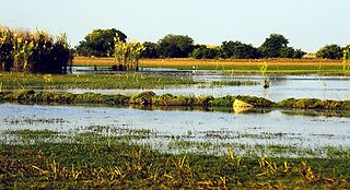
The Kafue Flats are a vast area of swamp, open lagoon and seasonally inundated flood-plain on the Kafue River in the Southern, Central and Lusaka provinces of Zambia. They are a shallow flood plain 240 km (150 mi) long and about 50 km (31 mi) wide, flooded to a depth of less than a meter in the rainy season, and drying out to a clayey black soil in the dry season.

Lukanga Swamp is a major wetland in the Central Province of Zambia, about 50 km west of Kabwe. Its permanently swampy area consists of a roughly circular area with a diameter of 40 to 50 km covering 1850 km2, plus roughly 250 km2 in the mouths of and along rivers discharging into it such as the Lukanga River from the north-east, plus another 500 km2 either side of the Kafue River to the west and north-west, making 2600 km2 in total. It contains many lagoons such as Lake Chiposhye and Lake Suye but few large channels, and its average depth is only 1.5 m.

Sioma Ngwezi National Park is a 5,000-square-kilometre park in the south west corner of Zambia. It is undeveloped and rarely visited, lacking roads and being off the usual tourist tracks, but this may change in the future.

The wildlife of Zambia refers to the natural flora and fauna of Zambia. This article provides an overview, and outline of the main wildlife areas or regions, and compact lists of animals focusing on prevalence and distribution in the country rather than on taxonomy. More specialized articles on particular groups are linked from here.
The biomes and ecoregions in the ecology of Zambia are described, listed and mapped here, following the World Wildlife Fund's classification scheme for terrestrial ecoregions, and the WWF freshwater ecoregion classification for rivers, lakes and wetlands. Zambia is in the Zambezian region of the Afrotropical biogeographic realm. Three terrestrial biomes are well represented in the country . The distribution of the biomes and ecoregions is governed mainly by the physical environment, especially climate.

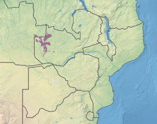
The Barotse Floodplain, also known as the Bulozi Plain, Lyondo or the Zambezi Floodplain, is one of Africa's great wetlands, on the Zambezi River in the Western Province of Zambia. It is a designated Ramsar site, regarded as being of high conservation value.
The Zambezian dry evergreen forest, also known as the Zambezian Cryptosepalum dry forest, is a tropical dry broadleaf forest ecoregion of Southern Africa. It consists of several areas of thick forest in western Zambia and adjacent Angola. It is one of the largest areas of tropical evergreen forest outside the equatorial zone.

The Zambezian coastal flooded savanna is a flooded grasslands and savannas ecoregion in Mozambique. It includes the coastal flooded savannas and grasslands in the deltas of the Zambezi, Pungwe, Buzi, and Save rivers.

The Western Zambezian grasslands is a tropical grassland ecoregion of eastern Zambia and adjacent parts of Angola. It is situated in two sections, to the north and south of the Barotse Floodplain. The region supports herds of ungulates, including Zambia's largest herd of Blue Wildebeast.
This page is based on this
Wikipedia article Text is available under the
CC BY-SA 4.0 license; additional terms may apply.
Images, videos and audio are available under their respective licenses.

