Lochinvar National Park

Last updated
Lochinvar National Park
Zambia relief location map.jpg
Red pog.svg
LocationZambia
Nearest cityMonze
Coordinates 15°51′S27°13′E / 15.850°S 27.217°E / -15.850; 27.217
Area428 km2 (165 sq mi)
Established1972
Governing bodyZambia Wildlife Authority
www.zambiatourism.com/destinations/national-parks/lochinvar-national-park

The Lochinvar National Park lies south west of Lusaka in Zambia, on the south side of the Kafue River.

Contents

A Map of Lochinvar National Park Lochinvar National Park.png
A Map of Lochinvar National Park

The habitats the national park protects are a large portion of the southern Kafue Flats floodplain, including the Chunga Lagoon, and drier woodland dominated by termite mounds. [1]

Lochinvar is also home to hot springs, echoing rocks, remains of a Neolithic settlement and an Iron Age village on Sebanzi Hill, also known for its caves, ancient baobab and wildlife. [1]

Protected areas of the Kafue Flats Kafue Flats.png
Protected areas of the Kafue Flats

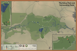
The park's northern boundary is marked by the Kafue River. In the south there are wooded hills. The park's total area is 428 square kilometres. [1]

The park is very similar to Blue Lagoon National Park on the other side of the Kafue on the northern flats. [2] [ citation needed ]

A former ranch, the park was designated in 1972 and is known for its Kafue lechwe and birdlife, with over 400 species recorded. The other antelopes found here are blue wildebeest, kudu and oribi. [1] The antelope and birds thrive in the absence of larger predators, which have been killed off by ranchers in the area. [3] The southern area of the park, which is a stretch of woodland dominated by Acacia albida and Combretum trees, is spared from the flooding that occurs in other parts of the park. This drier area is home to species like the bushbuck, kudu, baboon, bushpig and vervet monkey. [1] The marshes host a large number of waterfowl, including migratory species. [4]

The old colonial-style farmhouse serves as the lodge for the park. [5] [ citation needed ]

Lochinvar is the name of a loch in Galloway, Scotland.

See also

Related Research Articles

<span class="mw-page-title-main">Greater kudu</span> Species of woodland antelope

The greater kudu is a large woodland antelope, found throughout eastern and southern Africa. Despite occupying such widespread territory, they are sparsely populated in most areas due to declining habitat, deforestation, and poaching. The greater kudu is one of two species commonly known as kudu, the other being the lesser kudu, T. imberbis.

<span class="mw-page-title-main">Kafue River</span> River in Zambia

The Kafue River is the longest river lying wholly within Zambia at about 1,576 kilometres (979 mi) long. Its water is used for irrigation and for hydroelectric power. It is the largest tributary of the Zambezi, and of Zambia's principal rivers, it is the most central and the most urban. More than 50% of Zambia's population live in the Kafue River Basin and of these around 65% are urban.

<span class="mw-page-title-main">Chobe National Park</span> National park in Botswana

Chobe National Park is Botswana's first national park, and also the most biologically diverse. Located in the north of the country, it is Botswana's third largest park, after Central Kalahari Game Reserve and Gemsbok National Park.

<span class="mw-page-title-main">Kafue National Park</span> National Park in Zambia

Kafue National Park is the largest national park in Zambia, covering an area of about 22,400 km2. It is the second largest national park in Africa and is home to 152 different species of mammals. There are also 515 bird species, 70 reptile species, 58 species of fish and 36 amphibious species.

<span class="mw-page-title-main">Liuwa Plain National Park</span> National park in Zambia

Liuwa Plain National Park is a 3,369-square-kilometre (1,301 sq mi) national park in Zambia's Western Province. "Liuwa" means "plain" in the local Liuwa language, a dialect of Lozi language, and the plains originally served as a hunting ground for Lubosi Lewanika, the Litunga of the Lozi people. The area was designated as a protected area by Lubosi Lewanika in the early 1880s, and as a national park in 1972, when Zambia's government took over management. The nonprofit conservation organization African Parks has managed Liuwa in partnership with the Department of National Parks and Wildlife and the Barotse Royal Establishment since 2003.

The Kafue Flats are a vast area of swamp, open lagoon and seasonally inundated flood-plain on the Kafue River in the Southern, Central and Lusaka provinces of Zambia. They are a shallow flood plain 240 km (150 mi) long and about 50 km (31 mi) wide, flooded to a depth of less than a meter in the rainy season, and drying out to a clayey black soil in the dry season.

<span class="mw-page-title-main">Lukanga Swamp</span> Major wetland in Zambia

Lukanga Swamp is a major wetland in the Central Province of Zambia, about 50 km west of Kabwe. Its permanently swampy area consists of a roughly circular area with a diameter of 40 to 50 km covering 1850 km2, plus roughly 250 km2 in the mouths of and along rivers discharging into it such as the Lukanga River from the north-east, plus another 500 km2 either side of the Kafue River to the west and north-west, making 2600 km2 in total. It contains many lagoons such as Lake Chiposhye and Lake Suye but few large channels, and its average depth is only 1.5 m.

<span class="mw-page-title-main">Sioma Ngwezi National Park</span> National park in Zambia

Sioma Ngwezi National Park is a 5,000-square-kilometre park in the south west corner of Zambia. It is undeveloped and rarely visited, lacking roads and being off the usual tourist tracks, but this may change in the future.

<span class="mw-page-title-main">Wildlife of Zambia</span>

The wildlife of Zambia refers to the natural flora and fauna of Zambia. This article provides an overview, and outline of the main wildlife areas or regions, and compact lists of animals focusing on prevalence and distribution in the country rather than on taxonomy. More specialized articles on particular groups are linked from here.

<span class="mw-page-title-main">Zambezian flooded grasslands</span> Flooded grassland ecoregion in Africa

The Zambezian flooded grasslands is an ecoregion of southern and eastern Africa that is rich in wildlife.

The biomes and ecoregions in the ecology of Zambia are described, listed and mapped here, following the World Wildlife Fund's classification scheme for terrestrial ecoregions, and the WWF freshwater ecoregion classification for rivers, lakes and wetlands. Zambia is in the Zambezian region of the Afrotropical biogeographic realm. Three terrestrial biomes are well represented in the country . The distribution of the biomes and ecoregions is governed mainly by the physical environment, especially climate.

Blue Lagoon National Park is a small wildlife haven in the northern part of the Kafue Flats in Zambia's Central Province. It covers about 500 km2 (190 sq mi) and is very accessible, being about 100 km (60 mi) west of Lusaka.

<span class="mw-page-title-main">Barotse Floodplain</span> Major floodplain in Central Africa

The Barotse Floodplain, also known as the Bulozi Plain, Lyondo or the Zambezi Floodplain, is one of Africa's great wetlands, on the Zambezi River in the Western Province of Zambia. It is a designated Ramsar site, regarded as being of high conservation value.

Zambia, officially known as the Republic of Zambia, is a landlocked country in Southern Africa. The neighbouring countries are the Democratic Republic of the Congo to the north, Tanzania to the north-east, Malawi to the east, Mozambique, Zimbabwe, Botswana, and Namibia to the south, and Angola to the west. The capital city is Lusaka, located in the southeast of the country. The population is concentrated mainly around the capital and the Copperbelt to the northwest.

<span class="mw-page-title-main">Central Zambezian miombo woodlands</span>

The Central Zambezian miombo woodlands ecoregion spans southern central Africa. Miombo woodland is the predominant plant community. It is one of the largest ecoregions on the continent, and home to a great variety of wildlife, including many large mammals.

<i>Vossia cuspidata</i> Species of grass

Vossia is a monotypic genus in the grass family, found in Asia and Africa. The only known species is Vossia cuspidata, an aquatic grass native to Africa, and to Assam, Bangladesh, and northern Indochina. The common name is hippo grass.

The Gwisho hot-springs are an archaeological site in Lochinvar National Park, Zambia. The location is a rare site for its large quantity of preserved animal and plants remains. The site was first excavated by J. Desmond Clark in 1957, who found faunal remains and quartz tools in the western end of the site.

<span class="mw-page-title-main">Southern miombo woodlands</span>

The Southern miombo woodlands is a tropical grasslands and woodlands ecoregion extending across portions of Malawi, Mozambique, Zambia, and Zimbabwe.

References

  1. 1 2 3 4 5 "Lochinvar National Park". Lochinvar National Park. Retrieved 16 July 2013.
  2. "Lochinvar National Park. The Lochinvar National Park lies south west of Lusaka in Zambia, on the south side of the Kafue River. The national park straddles two". ww.en.freejournal.org. Retrieved 2021-05-18.
  3. Douthwaite, R. J.; van Lavieren, L. P. (January 1977). A Description of the Vegetation of Lochinvar National Park Zambia (PDF) (Report). National Council for Scientific Research, Lusaka, Zambia. p. 4. Retrieved 4 April 2021.
  4. Douthwaite, R. J. (January 1977). "Filter‐feeding ducks of the Kafue Flats, Zambia, 1971–1973". Ibis . 119 (1): 44–66. doi:10.1111/j.1474-919X.1977.tb02044.x.
  5. Lochinvar National Park. Lochinvar National Park.