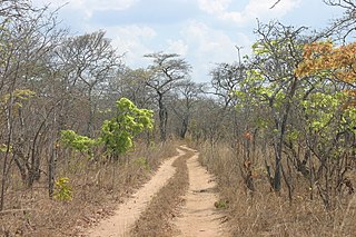
The small park (300km²) lies on the flat valley bottom, next to the river. The ecoregion at the site is Zambezian and Mopane woodlands, a woodland savanna type more tolerant of the hotter drier conditions at the bottom of the valley than the Miombo woodland savanna which covers most of the country. The elevation is 500–700 metres above sea level. In some places the trees are quite dense, in others they give way to grassland.
The life force of the Luangwa Valley is the Luangwa River. In the rainy season it floods and as it recedes, lagoons remain at the side of the main channel. The river does not dry up completely at Luambe but by the end of the dry season flows are reduced to a trickle. The river scene changes through the year according to the water level, which changes the topography of its banks and floodplain. This combination of water and land has created a very special ecosystem. In Luambe, there are numerous lagoons, which are visited by animals and birds in the dry season and which promote biodiversity.
Luambe National Park was unfunded until 1999. As a consequence, excessive poaching led to a drastic decline in wildlife. Only a few shy animals remained. Luangwa-Wilderness e.V., a non-profit association, aims to help with the preservation and rebuilding of the park. This is done in close cooperation with the Zambia Wildlife Authority (ZAWA) and with the involvement of local communities.
Lessons learnt from the neighbouring North Luangwa National Park, through work undertaken by the Frankfurt Zoological Society, illustrated how animal populations can be boosted with appropriate management and planning. In the last three years, the building of a lodge in Luambe National Park has already aided a good recovery and improvement in wildlife numbers.
The Zambezi is the fourth-longest river in Africa, the longest east-flowing river in Africa and the largest flowing into the Indian Ocean from Africa. Its drainage basin covers 1,390,000 km2 (540,000 sq mi), slightly less than half of the Nile's. The 2,574-kilometre-long (1,599 mi) river rises in Zambia and flows through eastern Angola, along the north-eastern border of Namibia and the northern border of Botswana, then along the border between Zambia and Zimbabwe to Mozambique, where it crosses the country to empty into the Indian Ocean.
The Luangwa River is one of the major tributaries of the Zambezi River, and one of the four biggest rivers of Zambia. The river generally floods in the rainy season and then falls considerably in the dry season. It is one of the biggest unaltered rivers in Southern Africa and the 52,000 square kilometres (20,000 sq mi) that make up the surrounding valley are home to abundant wildlife.
The Kafue River is the longest river lying wholly within Zambia at about 1,576 kilometres (979 mi) long. Its water is used for irrigation and for hydroelectric power. It is the largest tributary of the Zambezi, and of Zambia's principal rivers, it is the most central and the most urban. More than 50% of Zambia's population live in the Kafue River Basin and of these around 65% are urban.
South Luangwa National Park is in eastern Zambia, the southernmost of three national parks in the valley of the Luangwa River. It is a world-renowned wildlife haven which is known to locals simply as "the South Park." Concentrations of game along the meandering Luangwa River and its lagoons are amongst the most intense in Africa. The river teems with hippo and crocodile and provides a lifeline for one of the greatest diversities of habitat and wildlife, supporting more than 60 species of mammals and over 400 species of birds. It marks the end of the Great Rift Valley.
Mosi-oa-Tunya National Park is a UNESCO World Heritage Site that is home to one half of the Mosi-oa-Tunya — "The Smoke that Thunders", known worldwide as Victoria Falls — on the Zambezi River. The river forms the border between Zambia and Zimbabwe, so the falls are shared by the two countries, and the park is twin to the Victoria Falls National Park on the Zimbabwean side.
The southern reedbuck, rietbok or common reedbuck is a diurnal antelope typically found in southern Africa. It was first described by Pieter Boddaert, a Dutch physician and naturalist, in 1785. It is placed in the genus Redunca and family Bovidae. This antelope has an average mass of 58 kg (128 lb) and a body length of about 134–167 cm (53–66 in).
Grant's zebra is the smallest of the seven subspecies of the plains zebra. This subspecies represents the zebra form of the Serengeti-Mara ecosystem and others across central Africa.
The Kafue Flats are a vast area of swamp, open lagoon and seasonally inundated flood-plain on the Kafue River in the Southern, Central and Lusaka provinces of Zambia. They are a shallow flood plain 240 km long and about 50 km wide, flooded to a depth of less than a meter in the rainy season, and drying out to a clayey black soil in the dry season.
Lukusuzi National Park is located in eastern Luangwa Valley in Zambia, on the other side of the Luangwa River from the more famous South Luangwa National Park. It lies between the smaller Luambe National Park, and the Chipata-Lundazi road. Much of the park is plateau dissected by rocky ridges and rugged valleys. The main ecoregion in which the park lies is the southern miombo woodlands characterised by the miombo trees interspersed with grassland. At lower elevations, such as at the bottom of the Luangwa valley, miombo give way to mopane trees.
The Timbavati Private Nature Reserve is located at the border line between Hoedspruit and Acornhoek, north of the Sabi Sand Private Game Reserve on the western edge of Kruger National Park. Geographically and politically, Timbavati is located in Mpumalanga Province. In Xitsonga, the name 'Timbavati' means "the place where something sacred came down to Earth from the Heavens", and refers to the rare white lions of Timbavati.
The wildlife of Zambia refers to the natural flora and fauna of Zambia. This article provides an overview, and outline of the main wildlife areas or regions, and compact lists of animals focusing on prevalence and distribution in the country rather than on taxonomy. More specialized articles on particular groups are linked from here.
The Zambezian flooded grasslands is an ecoregion of southern and eastern Africa that is rich in wildlife.
The biomes and ecoregions in the ecology of Zambia are described, listed and mapped here, following the World Wildlife Fund's classification scheme for terrestrial ecoregions, and the WWF freshwater ecoregion classification for rivers, lakes and wetlands. Zambia is in the Zambezian region of the Afrotropical biogeographic realm. Three terrestrial biomes are well represented in the country . The distribution of the biomes and ecoregions is governed mainly by the physical environment, especially climate.
The Barotse Floodplain, also known as the Bulozi Plain, Lyondo or the Zambezi Floodplain, is one of Africa's great wetlands, on the Zambezi River in the Western Province of Zambia. It is a designated Ramsar site, regarded as being of high conservation value.
Zambia, officially known as the Republic of Zambia, is a landlocked country in Southern Africa. The neighbouring countries are the Democratic Republic of the Congo to the north, Tanzania to the north-east, Malawi to the east, Mozambique, Zimbabwe, Botswana, and Namibia to the south, and Angola to the west. The capital city is Lusaka, located in the southeast of the country. The population is concentrated mainly around the capital and the Copperbelt to the northwest.
The African Wildlife Foundation (AWF) is the leading international conservation organization focused exclusively on Africa's wildlife and wild lands.
The Zambezian and mopane woodlands is a tropical and subtropical grasslands, savannas, and shrublands ecoregion of southeastern Africa.
The Peace Park Foundation, founded in 1997 by Dr Anton Rupert, President Nelson Mandela and Prince Bernhard of the Netherlands, is an organization that aims to re-establish, renew and conserve large ecosystems in Africa, transcending man-made boundaries by creating regionally integrated and sustainably managed networks of Transfrontier Conservation Areas (TFCAs). Peace Parks Foundation has been involved in the establishment and development of ten of the 18 TFCAs found throughout southern Africa, all of which are in various stages of development. The establishment of each TFCA, or peace park, is complex and far-reaching, and involves several phases of activity, which can take many years to achieve.
The Southern miombo woodlands is a tropical grasslands and woodlands ecoregion extending across portions of Malawi, Mozambique, Zambia, and Zimbabwe.
This page is based on this Wikipedia article Text is available under the CC BY-SA 4.0 license; additional terms may apply. Images, videos and audio are available under their respective licenses.