
Zambia, officially the Republic of Zambia, is a landlocked country at the crossroads of Central, Southern and East Africa. It is typically referred to being in South-Central Africa or Southern Africa. It is bordered to the north by Democratic Republic of the Congo, Tanzania to the north-east, Malawi to the east, Mozambique to the southeast, Zimbabwe and Botswana to the south, Namibia to the southwest, and Angola to the west. The capital city of Zambia is Lusaka, located in the south-central part of Zambia. The population is concentrated mainly around Lusaka in the south and the Copperbelt Province to the north, the core economic hubs of the country.

The Zambezi is the fourth-longest river in Africa, the longest east-flowing river in Africa and the largest flowing into the Indian Ocean from Africa. Its drainage basin covers 1,390,000 km2 (540,000 sq mi), slightly less than half of the Nile's. The 2,574 km (1,599 mi) river rises in Zambia and flows through eastern Angola, along the north-eastern border of Namibia and the northern border of Botswana, then along the border between Zambia and Zimbabwe to Mozambique, where it crosses the country to empty into the Indian Ocean.

Victoria Falls is a waterfall on the Zambezi River in southern Africa, which provides habitat for several unique species of plants and animals. It is located on the border between Zambia and Zimbabwe and is one of the world's largest waterfalls, with a width of 1,708 m (5,604 ft).

The Victorian Alps, also known locally as the High Country, is a large mountain system in the southeastern Australian state of Victoria. Occupying the majority of eastern Victoria, it is the southwestern half of the Australian Alps, the tallest portion of the Great Dividing Range. The Yarra and Dandenong Ranges, both sources of rivers and drinking waters for Melbourne, are branches of the Victorian Alps.

Western Province is one of the 10 provinces in Zambia and encompasses most of the area formerly known as Barotseland. The capital is Mongu, and together with the neighbouring town of Limulunga, Mongu is treated as the capital of Barotseland.

Victoria Falls, popularly known as Vic Falls, is a resort town and city in the province of Matabeleland North, Zimbabwe. It lies on the southern bank of the Zambezi River at the western end of Victoria Falls themselves. According to the 2022 Population Census, the town had a population of 35,199.

Northern Province is one of Zambia's ten provinces. It covers approximately one-sixth of Zambia in land area. The provincial capital is Kasama. The province is made up of 12 districts, namely Kasama District, Chilubi District, Kaputa District, Luwingu District, Mbala District, Mporokoso District, Mpulungu District, Mungwi District, Nsama District, Lupososhi District, Lunte District and Senga Hill District. Currently, only Kasama and Mbala have attained municipal council status, while the rest are still district councils. It is widely considered to be the heartland of the Bemba, one of the largest tribes in Zambia.

Mosi-oa-Tunya National Park is a UNESCO World Heritage Site that is home to one-half of the Mosi-oa-Tunya—"The Smoke that Thunders", known worldwide as Victoria Falls—on the Zambezi River. The river forms the border between Zambia and Zimbabwe, so the falls are shared by the two countries, and the park is twin to the Victoria Falls National Park on the Zimbabwean side.

Liuwa Plain National Park is a 3,369-square-kilometre (1,301 sq mi) national park in Zambia's Western Province. "Liuwa" means "plain" in the local Liuwa language, a dialect of Lozi language, and the plains originally served as a hunting ground for Lubosi Lewanika, the Litunga of the Lozi people. The area was designated as a protected area by Lubosi Lewanika in the early 1880s, and as a national park in 1972, when Zambia's government took over management. The nonprofit conservation organization African Parks has managed Liuwa in partnership with the Department of National Parks and Wildlife and the Barotse Royal Establishment since 2003.

Luapula Province is one of Zambia's ten provinces located in the northern part of the country. Luapula Province is named after the Luapula River and its capital is Mansa. As per the 2022 Zambian census, the Province had a population of 1,519,478, which accounted for 7.72 per cent of the total Zambian population.

Nyika National Park is Malawi’s largest national park, with an area of 3200 km2.

The wildlife of Zimbabwe occurs foremost in remote or rugged terrain, in national parks and private wildlife ranches, in miombo woodlands and thorny acacia or kopje. The prominent wild fauna includes African buffalo, African bush elephant, black rhinoceros, southern giraffe, African leopard, lion, plains zebra, and several antelope species.

The wildlife of Zambia refers to the natural flora and fauna of Zambia. This article provides an overview, and outline of the main wildlife areas or regions, and compact lists of animals focusing on prevalence and distribution in the country rather than on taxonomy. More specialized articles on particular groups are linked from here.
The biomes and ecoregions in the ecology of Zambia are described, listed and mapped here, following the World Wildlife Fund's classification scheme for terrestrial ecoregions, and the WWF freshwater ecoregion classification for rivers, lakes and wetlands. Zambia is in the Zambezian region of the Afrotropical biogeographic realm. Three terrestrial biomes are well represented in the country . The distribution of the biomes and ecoregions is governed mainly by the physical environment, especially climate.
The following outline is provided as an overview of and topical guide to Zambia:
Zambia, officially known as the Republic of Zambia, is a landlocked country in Southern Africa. The neighbouring countries are the Democratic Republic of the Congo to the north, Tanzania to the north-east, Malawi to the east, Mozambique, Zimbabwe, Botswana, and Namibia to the south, and Angola to the west. The capital city is Lusaka, located in the southeast of the country. The population is concentrated mainly around the capital and the Copperbelt to the northwest.
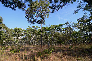
The Central Zambezian miombo woodlands ecoregion spans southern central Africa. Miombo woodland is the predominant plant community. It is one of the largest ecoregions on the continent, and home to a great variety of wildlife, including many large mammals.

Kawambwa District is a district of Zambia, located in Luapula Province. The capital lies at Kawambwa, which lies at the intersection of three roads: D19, M13, and Kawambwa-Mbereshi. The Luapula River forms its boundary with the Democratic Republic of the Congo. As of the 2000 Zambian Census, the district had a population of 102,503 people. It consists of two constituencies, namely Kawambwa and Pambashe.
Tourism in Zambia relates to tourism in the African nation Zambia. The tourism industry is a major and growing industry in Zambia. Zambia has more than 2500 lions along with several National parks, waterfalls, lakes, rivers, and historic monuments. Zambia has been involved in several agreements on tourism with nations like Uganda and Kenya. Uganda Ministry of Tourism and Arts said Zambia is a model in tourism in Africa. Zambia Tourism Agency (ZTA) has partnered with the Government through the Ministry of Tourism and private sector to enhance the marketing aspect in the tourism industry.
