
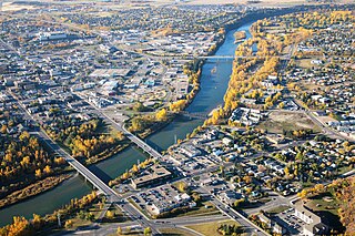
Fredericton is the capital city of the Canadian province of New Brunswick. The city is situated in the west-central portion of the province along the Saint John River, also known by its Indigenous name of Wolastoq, which flows west to east as it bisects the city. The river is the dominant natural feature of the area. One of the main urban centres in New Brunswick, the city had a population of 63,116 and a metropolitan population of 108,610 in the 2021 Canadian census. It is the third-largest city in the province after Moncton and Saint John.
Red Deer is a city in Alberta, Canada, located midway on the Calgary–Edmonton Corridor. Red Deer serves central Alberta, and its key industries include health care, retail trade, construction, oil and gas, hospitality, manufacturing and education. It is surrounded by Red Deer County and borders on Lacombe County. The city is in aspen parkland, a region of rolling hills, alongside the Red Deer River.
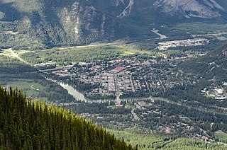
Banff is a resort town in Banff National Park, Alberta, Canada, in Alberta's Rockies along the Trans-Canada Highway, 126 km (78 mi) west of Calgary and 58 km (36 mi) east of Lake Louise, 1,400 to 1,630 m above sea level,

Ankara Province (Turkish: Ankara ili, pronounced[ˈaŋkaɾaiˈli], is a province and metropolitan municipality of Turkey with the capital city Ankara. Its area is 25,632 km2, and its population is 5,782,285.

Kitikmeot Region is an administrative region of Nunavut, Canada. It consists of the southern and eastern parts of Victoria Island with the adjacent part of the mainland as far as the Boothia Peninsula, together with King William Island and the southern portion of Prince of Wales Island. The regional centre is Cambridge Bay.

Western Province is one of the 10 provinces in Zambia and encompasses most of the area formerly known as Barotseland. The capital is Mongu, and together with the neighbouring town of Limulunga, Mongu is treated as the capital of Barotseland.
Rumphi is a district in the Northern Region of Malawi. The capital is Rumphi. The district covers an area of 4,769 km.² and has a population of 128,360.
Kawambwa is a town in the Zambian province of Luapula located on the edge of the northern Zambian plateau above the Luapula valley at an altitude of 1300 m. It was chosen as an administrative district of the same name by the British colonial authorities who preferred the climate of the plateau rather than the hotter valley where most of the district's population live, and it continues as an administrative district today.

Luapula Province is one of Zambia's ten provinces located in the northern part of the country. Luapula Province is named after the Luapula River and its capital is Mansa. As per the 2022 Zambian census, the Province had a population of 1,519,478, which accounted for 7.72 per cent of the total Zambian population.

Lusaka Province is one of the ten provinces of Zambia. It is the smallest in terms of land area, covering 21,896 km2. However, it is the most populated and densely populated province in Zambia, with a population of 3,079,964 as of 2022 and a population density of 140 persons per km2.

Sesheke District is one of the sixteen (16) districts in Western Province of Zambia. Lying 300km south of the provincial capital, Mongu and 190km from Livingstone, the nations tourist capital, the district shares borders with Sioma in the west, Senanga and Mulobezi in the north-east and Mwandi in the east. The district also shares international border with Namibia south and Angola in south-west. The capital lies at Sesheke. As of the 2000 Zambian Census, the district had a population of 78,169 people. It contains Sioma Ngwezi National Park and contains part of the Zambezi River, which forms Zambia's border with Namibia.

Kabwe District is a district of Zambia, located in Central Province. The capital lies at Kabwe. As of the 2010 Zambian Census, the district had a population of 299,206 people. It consists of two constituencies, namely Kabwe Central and Bwacha.

Mumbwa District is a district of Zambia, located in Central Province. The capital lies at Mumbwa. As of the 2022 Zambian Census, the district had a population of 332,237 people. It consists of two constituencies, being Mumbwa and Nangoma.

Chingola District is a district of Zambia, located in Copperbelt Province. The capital lies at Chingola. As of the 2022 Zambian Census, the district had a population of 299,936 people. It is divided into two constituencies, namely Chingola constituency and Nchanga constituency.

Zambezi District is a district of Zambia, located in North-Western Province. The capital lies at Zambezi. As of the 2022 Zambian Census, the district had a population of 108,220 people. It consists of two constituencies, namely Zambezi West and Zambezi East.

Lundazi District is a district of Zambia, located in Eastern Province. The capital lies at Lundazi. As of the 2022 Zambian Census, the district had a population of 154,908 people. In 2018, Lundazi district was divided into 3 districts by the Government of the Republic of Zambia to enable rural development.

Nchelenge District is a district of Zambia, located in the Luapula Province. The capital lies at Nchelenge. As of the 2022 Zambian Census, the district had a population of 233,696 people.
Lusenga Plain National Park is a national park in the Kawambwa District, Luapula Province of Zambia, to the south-east of Lake Mweru.

Rufunsa District is a district in Zambia, located in Lusaka Province. The district capital is Rufunsa. The district was established by President Michael Sata in 2012 by splitting Chongwe District. As of the 2022 Zambian census, it has a population of 81,733.

Muchinga Province is one of the ten provinces of Zambia. It is located in the northeast of the country and borders with Tanzania in the north, Malawi in the east, Eastern Province in the south, Central Province in the southwest, Luapula Province in the west, and Northern Province in the northwest. The administrative center of the province is Chinsali.
