
Luapula Province is one of Zambia's ten provinces located in the northern part of the country. Luapula Province is named after the Luapula River and its capital is Mansa. As per the 2022 Zambian census, the Province had a population of 1,519,478, which accounted for 7.72 per cent of the total Zambian population.
Kazembe is a name used for Mwata Kazembe's town in the Luapula Province of Zambia, especially on maps and in the Zambian postal service. The other name for the town is Mwansabombwe and this is the one used by its or Luba or Chibemba-speaking inhabitants. They may refer in English to "Kazembe's Village" or just "Kazembe", as traditionally a settlement is named after the chief or headman, rather than the location. The Luba-Lunda shared with many tribes the custom of moving to another village or a new site on the death of the chief. Historical references to a village or town may actually be to a different location. For instance when the explorer David Livingstone visited Mwata Kazembe in 1867 and 1868, "Casembe's town", as he wrote it, was further north at the town now called Kanyembo.
Mbereshi is a village in the Luapula Province of Zambia, named after the Mbereshi River on its north side. It is the site of a large mission founded in 1900 by the London Missionary Society. In 1915 the mission established Mbereshi Girls' School, the first girls' school in the territory, as well as a boys' school and a large hospital. The Girls school and Hospital are now Grant Aided institutions run by The United Church of Zambia. Mbereshi contains a number of examples of mission buildings, including a large church which is now part of the United Church of Zambia.
Mpulungu District is a district of Zambia, located in Northern Province. The capital lies at Mpulungu. As of the 2022 Zambian Census, the district had a population of 153,564 people.

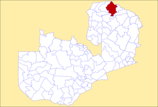
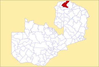
Chipili District is a district of Zambia, located in Luapula Province. It was separated from Mwense District in 2012. As of the 2022 Zambian Census, the district had a population of 47,210 people.

Sikongo District is a district of Zambia, located in Western Province. It was separated from Kalabo District in 2012. As of the 2022 Zambian Census, the district had a population of 59,670 people.

Chisamba District is a district of Central Province, Zambia. It covers a total surface area of 5,204.5 sq km and is known for its agricultural activities with over 32,000 small scale farming families and 256 commercial farmers, the majority of whom are white Zambians. It shares borders with Lusaka, Chongwe, Chibombo, Kabwe, Kapiri Mposhi and Luano Districts. As of the 2022 Zambian Census, the district had a population of 160,828 people.

Chitambo District is a district of Central Province, Zambia. It was separated from Serenje District in 2012 and is located some 357km north-east of Kabwe along the Great North Road. As of the 2022 Zambian Census, the district had a population of 100,603 people.

Luano District is a district of Central Province, Zambia. It was separated from Mkushi District in 2012. As of the 2022 Zambian Census, the district had a population of 66,679 people.

Ngabwe District is a district of Central Province, Zambia. It was separated from Kapiri Mposhi District in 2012. As of the 2022 Zambian Census, the district had a population of 42,104 people.

Chilanga District is a district of Lusaka Province, Zambia. The capital of the district is Chilanga. It was separated from Kafue District in 2012. As of the 2022 Zambian Census, the district had a population of 225,276 people.

Chirundu District is a district of Southern Province, Zambia. Its headquarters is Chirundu. It was separated from Siavonga District by President Michael Sata in 2012. As of the 2022 Zambian Census, the district had a population of 78,780 people.

Shibuyunji District, also known as Sibuyunji District, is a district of Central Province, Zambia. As of the 2022 Zambian Census, the district had a population of 91,616 people.

Shiwang'andu District is a district of Muchinga Province, Zambia. It was created in February 2013 by splitting Chinsali District. It is named after Lake Ishiba Ng'andu and the district also contains the Shiwa Ngandu Estate. As of the 2022 Zambian Census, the district had a population of 78,509 people.
Nsama District is a district of Northern Province, Zambia. It was created in February 2012 by splitting Kaputa District. As of the 2022 Zambian Census, the district had a population of 77,651 people.

Ikelenge District is a district of North-Western Province, Zambia. It was separated from Mwinilunga District in 2011. As of the 2022 Zambian Census, the district had a population of 44,775 people.

Manyinga District is a district of North-Western Province, Zambia. It was separated from Kabompo District in 2012. As of the 2022 Zambian Census, the district had a population of 75,030 people.

Chikankata District is a district of Southern Province, Zambia. It was separated from Mazabuka District in December 2011. As of the 2022 Zambian Census, the district had a population of 98,671 people.

Pemba District is a district of Southern Province, Zambia. The district capital is Pemba. It was separated from Choma District in 2012. As of the 2022 Zambian Census, the district had a population of 101,021 people.

Nkeyema District is a district of Western Province, Zambia. It was separated from Kaoma District in 2012. As of the 2022 Zambian Census, the district had a population of 106,074 people.
