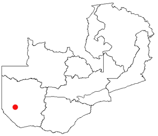
Senanga is the capital of the Senanga District, which is located in the Western Province of Zambia. The town is situated on the eastern bank of the Zambezi River, at the southern end of the Barotse Floodplain. It lies on the main road running parallel to the river from Livingstone and Sesheke to Mongu. Recently the Kaunga Lyeti Bridge was completed to cross the Kaunga Lyeti River near the junction to Sioma, traveling from Sesheke and Katima Mulilo. On top of the bridgework, recent road projects have improved travel conditions and inspired economic confidence and growth.
Zimba is a market town in southern Zambia, 70 kilometres northeast of Livingstone, on the main road and railway line to Lusaka.
Samfya is a town located in the Zambian province of Luapula. It is the centre of Samfya District. The town is located on the south-western shore of Lake Bangweulu, on the longest stretch of well-defined shore of that lake. Samfya has a few guesthouses and a number of white sandy beaches which are used for recreation, although the lake does have crocodiles.

Central Province is one of Zambia's ten provinces. The provincial capital is Kabwe, which is the home of the Mulungushi Rock of Authority. Central Province has an area of 94,394 km (58,654 mi). It borders eight other provinces and has eleven districts. The total area of forest in the province is 9,095,566 ha, and it has a national park and three game management areas. The first mine in the region was opened up in 1905 making the then Broken Hill town the first mining town. In 1966, the town's name was reverted to its indigenous name - Kabwe meaning 'ore' or 'smelting'.

The ten provinces of Zambia are divided into a total of 116 districts as of 2018.

Livingstone District is a district of Zambia, located in Southern Province. The capital lies at Livingstone. As of the 2022 Zambian Census, the district had a population of 177,393 people. Its border with Zimbabwe is formed by the Zambezi River and Victoria Falls. Although most people live in Livingstone, other villages include Jinga Jinga in the north and Simonga in the southwest.
Luampa District is a district of Zambia, located in Western Province. It was separated from Kaoma District in 2012.

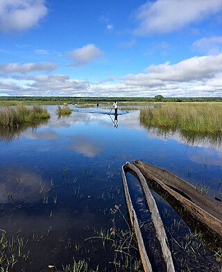
Mitete District is a district of Zambia, located in Western Province. It was separated from Lukulu District in 2012.
Mulobezi District is a district of Zambia, located in Western Province. It was separated from Sesheke District in 2013.
Mwandi District is a district of Zambia, located in Western Province. The capital lies at Mwandi. It was separated from Sesheke District in 2012.

Nalolo District is a district of Zambia, located in Western Province. It was separated from Senanga District in 2012.

Chisamba District is a district of Central Province, Zambia. It covers a total surface area of 5,204.5 sq km and is known for its agricultural activities with over 32,000 small scale farming families and 256 commercial farmers, the majority of whom are white Zambians. It shares borders with Lusaka, Chongwe, Chibombo, Kabwe, Kapiri Mposhi and Luano Districts. The District has a total population of 160,828.

Chitambo District is a district of Central Province, Zambia. It was separated from Serenje District in 2012 and is located some 357km north-east of Kabwe along the Great North Road. It shares borders with Serenje, Samfya, Lavushimanda and the Democratic Republic of Congo.

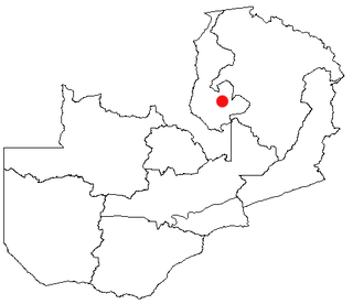
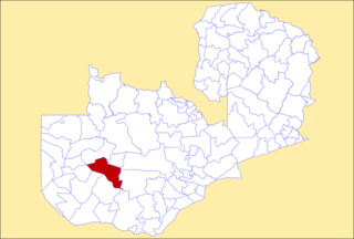
Luano District is a district of Central Province, Zambia. It was separated from Mkushi District in 2012.

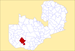
Ngabwe District is a district of Central Province, Zambia. It was separated from Kapiri Mposhi District in 2012.

Chilanga District is a district of Lusaka Province, Zambia. The capital of the district is Chilanga. It was separated from Kafue District in 2012.

Chirundu District is a district of Southern Province, Zambia. Its headquarters is Chirundu. It was separated from Siavonga District by President Michael Sata in 2012.

Manyinga District is a district of North-Western Province, Zambia. It was separated from Kabompo District in 2012.

Pemba District is a district of Southern Province, Zambia. The district capital is Pemba. It was separated from Choma District in 2012.
Mapatizya is a constituency of the National Assembly of Zambia. It covers Zimba District in Southern Province, including the town of Zimba.
