
Zambia, officially the Republic of Zambia, is a landlocked country at the crossroads of Central, Southern and East Africa, although it is typically referred to as being in Southern Africa at its most central point. Its neighbours are the Democratic Republic of the Congo to the north, Tanzania to the northeast, Malawi to the east, Mozambique to the southeast, Zimbabwe and Botswana to the south, Namibia to the southwest, and Angola to the west. The capital city of Zambia is Lusaka, located in the south-central part of Zambia. The nation's population of around 19.5 million is concentrated mainly around Lusaka in the south and the Copperbelt Province to the north, the core economic hubs of the country.

Northern Province is one of Zambia's ten provinces. It covers approximately one sixth of Zambia in land area. The provincial capital is Kasama. The province is made up of 12 districts, namely Kasama District, Chilubi District, Kaputa District, Luwingu District, Mbala District, Mporokoso District, Mpulungu District, Mungwi District, Nsama District, Lupososhi District, Lunte District and Senga Hill District. Currently, only Kasama and Mbala have attained municipal council status, while the rest are still district councils. It is widely considered to be the heartland of the Bemba, one of the largest tribes in Zambia.

Kasanka National Park is a park located in the Chitambo District of Zambia’s Central Province. At roughly 390 km2 (150 sq mi), Kasanka is one of Zambia’s smallest national parks. Kasanka was the first of Zambia’s national parks to be managed by a private-public partnership. The privately funded Kasanka Trust Ltd has been in operation since 1986 and undertakes all management responsibilities, in partnership with the Department of National Parks and Wildlife. The park has an average elevation between 1,160 m (3,810 ft) and 1,290 m (4,230 ft) above mean sea level. It has a number permanent shallow lakes and water bodies with the largest being Wasa. There are five perennial rivers in the park, with the largest being the Luwombwa River. The Luwombwa is the only river that drains the NP, which flows out in the northwestern corner. It is a tributary of the Luapula, which further upstream also drains the Bangweulu Swamp and forms the main source of the Congo River. Although Kasanka NP is part of the Greater Bangweulu Ecosystem, there is no direct hydrological connection between the park and the Bangweulu Wetlands.
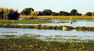
The Bangweulu Wetlands is a wetland ecosystem adjacent to Lake Bangweulu in north-eastern Zambia. The area has been designated as one of the world's most important wetlands by the Ramsar Convention and an "Important Bird Area" by BirdLife International. African Parks began managing Bangweulu in partnership with Zambia's Department of National Parks and Wildlife with the establishment of the Bangweulu Wetland Management Board in 2008.

Central Province is one of Zambia's ten provinces. The provincial capital is Kabwe, which is the home of the Mulungushi Rock of Authority. Central Province has an area of 94,394 km (58,654 mi). It borders eight other provinces and has eleven districts. The total area of forest in the province is 9,095,566 ha, and it has a national park and three game management areas. The first mine in the region was opened up in 1905 making the then Broken Hill town the first mining town. In 1966, he town's name was reverted to its indigenous name - Kabwe meaning 'ore' or 'smelting'.

Luapula Province is one of Zambia's ten provinces located in the northern part of the country. Luapula Province is named after the Luapula River and its capital is Mansa. As per the 2010 Zambian census, the Province had a population of 991,927, which accounted for 7.57 per cent of the total Zambian population.
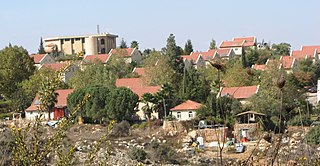
Ofra is an Israeli settlement located in the northern West Bank. Located on the main road between Jerusalem and Nablus, it falls under the jurisdiction of Mateh Binyamin Regional Council. In 2019 it had a population of 3,043.
Water transport and the many navigable inland waterways in Zambia have a long tradition of practical use except in parts of the south. Since draught animals such as oxen were not heavily used, water transport was usually the only alternative to going on foot until the 19th Century. The history and current importance of Zambian waterways, as well as the types of indigenous boats used, provide information on this important aspect of Zambian economy.

The wildlife of Zambia refers to the natural flora and fauna of Zambia. This article provides an overview, and outline of the main wildlife areas or regions, and compact lists of animals focusing on prevalence and distribution in the country rather than on taxonomy. More specialized articles on particular groups are linked from here.

The Zambezian flooded grasslands is an ecoregion of southern and eastern Africa that is rich in wildlife.

Chilubi District with headquarters at Chilubi is located in Northern Province, Zambia. It covers the north-east Lake Bangweulu and Bangweulu Wetlands containing several islands including Chilubi Island, and some of the mainland northeast of the lake. As of the 2000 Zambian Census, the district had a population of 66,338 people.
The biomes and ecoregions in the ecology of Zambia are described, listed and mapped here, following the World Wildlife Fund's classification scheme for terrestrial ecoregions, and the WWF freshwater ecoregion classification for rivers, lakes and wetlands. Zambia is in the Zambezian region of the Afrotropical biogeographic realm. Three terrestrial biomes are well represented in the country . The distribution of the biomes and ecoregions is governed mainly by the physical environment, especially climate.
Zambia, officially known as the Republic of Zambia, is a landlocked country in Southern Africa. The neighbouring countries are the Democratic Republic of the Congo to the north, Tanzania to the north-east, Malawi to the east, Mozambique, Zimbabwe, Botswana, and Namibia to the south, and Angola to the west. The capital city is Lusaka, located in the southeast of the country. The population is concentrated mainly around the capital and the Copperbelt to the northwest.

Migron is an Israeli illegal settlement (outpost) in the West Bank, located within 2 km of a former outpost by the same name, that was relocated to its present site on 2 September 2012. The outpost was located 14 kilometers north of Jerusalem, it fell under the jurisdiction of the Mateh Binyamin Regional Council. It was the largest outpost of its kind, with a population of 300. The council says it was founded in 1999 and re-founded in 2001, on land registered before 1967 by the villagers of Burqa. The Israeli government contributed NIS 4.3 million from the Construction and Housing Ministry to build Migron. The international community considers Israeli settlements in the West Bank illegal under international law, whereas Israeli outposts, like Gevaot, are considered illegal not only under international law but also under Israeli law.

Lusaka is the capital and largest city of Zambia. It is one of the fastest-developing cities in southern Africa. Lusaka is in the southern part of the central plateau at an elevation of about 1,279 metres (4,196 ft). As of 2019, the city's population was about 3.3 million, while the urban population is estimated at 2.5 million in 2018. Lusaka is the centre of both commerce and government in Zambia and connects to the country's four main highways heading north, south, east and west. English is the official language of the city administration, while Bemba, Tonga, Lenje, Soli, Lozi and Nyanja are the commonly spoken street languages.
The Bangweulu tsessebe is a population and possible taxon of Damaliscus lunatus, which are large African antelopes of the grasslands. This population is presently restricted to northern Zambia in the wild, although it was recorded as occurring in neighbouring southernmost Democratic Republic of the Congo in the 1940s. Also seen as the northernmost population belonging to the nominate southern sassaby subspecies, in 2003 it was described as a new species, only to be downgraded to a subspecies a few years later. Its taxonomic status is unclear as of 2021. As an individual sassaby of this taxon cannot be clearly distinguished from populations to the south, the taxon was defined using an experimental suite of statistical techniques applied to a sample set, based on multivariate analysis, and recognised under an experimental new taxonomy. Nominate sassaby antelopes become progressively darker on average in the northern populations, and on average have a slightly thicker horns at the base of the skull, but those of northern Zambia are the darkest and with the most robust horns on average.
Digya National Park is the second largest national park and the oldest protected area in Ghana. It is located in the Bono East Region. It was created in 1900 and given national park status in 1971. The park is the only wildlife territory in Ghana to have Lake Volta at its borders.

The Twa are a group of indigenous African Pygmy tribes.
Lavushi Manda National Park is a national park in the Muchinga Province of Zambia with an area of 1,500 sq km. It is the 11th largest of the 20 National Parks in Zambia. The park was initially gazetted as a Game Reserve in 1941, and was declared a National Park in 1972. It is located in Muchinga Province, in a district of the same name (Lavushimanda), with the South Luangwa National Park in the neighbouring Mpika District. It is adjacent to Bangweulu Game Management Area to the northwest, Kafinda Game Management Area lies further west. The chiefdom of Chiundaponde is in the northwest, north lies Luchembe, northwest Chikwanda, east Mpumba, and south lies Muchinka chiefdom. It covers a small range of mountains and hills, and is principally covered in miombo woodlands, with a number of rivers and streams, and a few areas of grassland, both on drier land or in the form of seasonally wet dambos. There are few large mammals, due to poaching in the previous century, but fishing and hiking are possible. Certain antelope species retreat upland to the park from the Bangweulu swamps to the northwest during the rainy season.
