
Malawi is a landlocked country in southeast Africa. It is wholly within the tropics; from about 9°30S at its northernmost point to about 17°S at the southernmost tip. The country occupies a thin strip of land between Zambia and Mozambique, extending southwards into Mozambique along the valley of the Shire River. In the north and north east it also shares a border with Tanzania. Malawi is connected by rail to the Mozambican ports of Nacala and Beira. It lies between latitudes 9° and 18°S, and longitudes 32° and 36°E.

South Luangwa National Park is in eastern Zambia, the southernmost of three national parks in the valley of the Luangwa River. It is a world-renowned wildlife haven which is known to locals simply as "the South Park." Concentrations of game along the meandering Luangwa River and its lagoons are amongst the most intense in Africa. The river teems with hippo and crocodile and provides a lifeline for one of the greatest diversities of habitat and wildlife, supporting more than 60 species of mammals and over 400 species of birds. It marks the end of the Great Rift Valley.

The Nyika Plateau lies in northern Malawi, with a small portion in north eastern Zambia. Most of it lies at elevations of between 2,100 and 2,200 m, the highest point being 2,605 m (8,547 ft) at Nganda Peak. It is roughly a diamond in shape, with a long north–south axis of about 90 km (56 mi), and an east–west axis of about 50 km (31 mi). It towers above Lake Malawi, and the towns of Livingstonia and Chilumba. Its well-defined north-west escarpment rises about 700 m (2,300 ft) above the north-eastern extremity of the Luangwa Valley, and its similarly prominent south-east escarpment rises about 1,000 m (3,300 ft) above the South Rukuru River valley. It is very different in scenery from other parts of Malawi, consisting of rolling hills with little streams in broad valleys, and rough grassland with clumps of pine trees.
Rumphi is a district in the Northern Region of Malawi. The capital is Rumphi. The district covers an area of 4,769 km.² and has a population of 128,360.

The Great East Road is a major road in Zambia and the main route linking its Eastern Province with the rest of the country. It is also the major link between Zambia and Malawi and between Zambia and northern Mozambique. However, the route does not carry as much traffic as many of the other regional arterial roads and between the main cities it serves, Lusaka and Chipata, it passes through rural and wilderness areas. In Lusaka the road forms the main arterial road for the eastern suburbs. The entire route from Lusaka to Chipata and the Malawi Border Post is designated the T4 Road on Zambia's road network.

Eastern Province is one of Zambia's ten provinces. The province lies between the Luangwa River and borders with Malawi to the east and Mozambique to the south, from Isoka in the northeast to the north of Luangwa in the south. The provincial capital is Chipata. Eastern province has an area of 51,476 km2 (19,875 sq mi), locally shares border with three other provinces of the country and is divided into fifteen districts.
Nyika National Park is Malawi’s largest national park, with an area of 3200 km2.
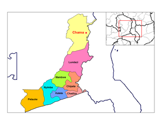
Chama is a small town in the Eastern Province of Zambia, and is headquarters of Chama District. It is one of the most remote district headquarters in the country, lying just inside the eastern edge of the upper Luangwa Rift Valley, at the foot of the highlands dividing Zambia and Malawi. It is served by only one gravel road which comes from Lundazi and the provincial capital of the Eastern Province, Chipata, 300 km to the south. A dirt track connects the town to the South Luangwa National Park 200 km south-west, running parallel to the Luangwa River. A little-used dirt track follows the Malawi border further north and crosses into Isoka District west of the Nyika Plateau. The Road Development Agency is also developing a road from Chama westwards across the Luangwa River to the town of Matumbo, where the road will end at a junction with the T2 Road, Zambia's Great North Road. It is meant to be the 2nd main road out of Chama after the Lundazi-Chipata Route and is meant to provide access for Chama Residents to the headquarters of Muchinga Province, which is Chinsali.

The wildlife of Malawi is composed of the flora and fauna of the country. Malawi is a landlocked country in southeastern Africa, with Lake Malawi taking up about a third of the country's area. It has around 187 species of mammal, some 648 species of birds have been recorded in the country and around 500 species of fish, many of them endemic, are found in its lakes and rivers. About 20% of the country has been set aside as national parks and game and forest reserves.

The wildlife of Zambia refers to the natural flora and fauna of Zambia. This article provides an overview, and outline of the main wildlife areas or regions, and compact lists of animals focusing on prevalence and distribution in the country rather than on taxonomy. More specialized articles on particular groups are linked from here.
The biomes and ecoregions in the ecology of Zambia are described, listed and mapped here, following the World Wildlife Fund's classification scheme for terrestrial ecoregions, and the WWF freshwater ecoregion classification for rivers, lakes and wetlands. Zambia is in the Zambezian region of the Afrotropical biogeographic realm. Three terrestrial biomes are well represented in the country . The distribution of the biomes and ecoregions is governed mainly by the physical environment, especially climate.
Malawi, officially known as the Republic of Malawi, is a country located in southeastern Africa. The country is also referred to as "The Warm Heart of Africa", due to the friendliness of the people.

Vwaza Marsh Game Reserve is a national game reserve in Malawi.
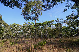
The Central Zambezian miombo woodlands ecoregion spans southern central Africa. Miombo woodland is the predominant plant community. It is one of the largest ecoregions on the continent, and home to a great variety of wildlife, including many large mammals.

The Mafinga Hills are a plateau covered by hills, situated on the border between Zambia and Malawi, in Southern Africa. These hills are composed of quartzites, phyllites and feldspathic sandstones of sedimentary origin.

Nyasa Express is a Malawian airline that offers both seat rate and charter commercial air services from their base at Kamuzu International Airport in Lilongwe, Malawi. The company began operations in 2011, and provides services throughout Malawi and the region. The airline currently operates a fleet of four propeller aircraft models.

The South Malawi montane forest-grassland mosaic is a montane grasslands and shrublands ecoregion of Tanzania, Malawi, Mozambique, and Zambia.
The Misuku Hills are a mountain range in Malawi's Northern Region.
The M14 is a road in the Muchinga Province of Zambia that connects Nakonde with the Malawian Border at Katumbi via Chitipa, Thendere and Muyombe.