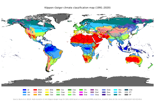
The Köppen climate classification is one of the most widely used climate classification systems. It was first published by German-Russian climatologist Wladimir Köppen (1846–1940) in 1884, with several later modifications by Köppen, notably in 1918 and 1936. Later, German climatologist Rudolf Geiger (1894–1981) introduced some changes to the classification system in 1954 and 1961, which is thus sometimes called the Köppen–Geiger climate classification.
Mchinji is a town and the capital of the Mchinji District in the Central Region of Malawi. Mchinji Boma, located 12 kilometres from the Zambian border and 109 km (68 mi) from the national capital, Lilongwe, is the major hub of government and general business. It has a major railroad junction, being the railhead nearest to Zambia. The area's economy is sustained by rain-fed agriculture.
Solwezi is a town in Zambia. It is the provincial capital of the mineral-rich North-Western Province. Solwezi is also the administrative capital of Solwezi District, one of the eleven districts in the North-Western Province.

Miombo woodland is a tropical and subtropical grasslands, savannas, and shrublands biome located in central and southern tropical Africa. It includes three woodland savanna ecoregions characterized by the dominant presence of Brachystegia and Julbernardia species of trees, and has a range of climates ranging from humid to semi-arid, and tropical to subtropical or even temperate. The trees characteristically shed their leaves for a short period in the dry season to reduce water loss and produce a flush of new leaves just before the onset of the wet season with rich gold and red colours masking the underlying chlorophyll, reminiscent of autumn colours in the temperate zone.
Mbala is Zambia's most northerly large town and seat of Mbala District in Northern Province, occupying a strategic location close to the border with Tanzania and controlling the southern approaches to Lake Tanganyika, 40 km by road to the north-west, where the port of Mpulungu is located. It had a population of about 20,000 in 2006. Under the name Abercorn, Mbala was a key outpost in British colonial control of this part of south-central Africa.

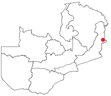
Chipata is a city and administrative centre of the Eastern Province of Zambia and Chipata District. It was declared the 5th city of the country, after Lusaka, Ndola, Kitwe and Livingstone, by President Edgar Lungu on 24 February 2017. The city has undergone rapid economic and infrastructure growth in the years, leading up to city status.
Kasama is a town in the Northern Province of Zambia. It serves as the provincial capital and the headquarters of Kasama District.

Kalabo is an urban centre and the seat of Kalabo District, in the Western Province of Zambia.
Mumbwa is a town in the Central Province of Zambia, lying on the M9 Road. Its district covers the western part of the Central Province bordering Kaoma and Western Province to the west, Namwala and Southern Province to the south, Lusaka and Lusaka Province to the east, Kasempa and North-Western Province to the north and Kabwe to the north-east. It is known for its cotton and has a ginnery. The Zambia Air Force has a base in the district. Kafue National Park borders the district to the west. The predominant tribes are the Ila, who speak a dialect known as Sala, mostly to the south and south east and the Kaonde to the north. The Lenje are to the north-east on the border area with Kabwe. There are also relatively large settlement of people from the west and north west such as the Lozi, Nkoya and Luvale, Shona people from the then Southern Rhodesia who settled there as refugees from the civil war in that country and who are now almost integrated and Tonga from the south. A lot of prospecting for minerals such as copper and gold was done in the district and small scale mines operated there. Most are now closed, though the gold mine at Luiri has been revived.

Serenje is a town in Serenje District, Central Province, Zambia, lying just off the Great North Road and TAZARA Railway. Serenje has a railway station on the TAZARA railway. Serenje is approximately 191 km from Kapiri Mposhi on the Great North Road. Mkushi is the district west of Serenje. The Mulembo Falls lie near the town.
Kaoma is a town in Zambia. It is the headquarters of Kaoma District in the Western Province and is located on the M9 Road.
Kawambwa is a town in the Zambian province of Luapula located on the edge of the northern Zambian plateau above the Luapula valley at an altitude of 1300 m. It was chosen as an administrative district of the same name by the British colonial authorities who preferred the climate of the plateau rather than the hotter valley where most of the district's population live, and it continues as an administrative district today.

Isoka is a town located in the Muchinga Province of Zambia near the borders with Tanzania and Malawi. It lies on the T2 Road.

Eastern Province is one of Zambia's ten provinces. The province lies between the Luangwa River and borders with Malawi to the east and Mozambique to the south, from Isoka in the northeast to the north of Luangwa in the south. The provincial capital is Chipata. Eastern province has an area of 51,476 km2 (19,875 sq mi), locally shares border with three other provinces of the country and is divided into fifteen districts.
Mfuwe is the main settlement of South Luangwa National Park in the Eastern Province of Zambia, serving the tourism industry and wildlife conservation in the Luangwa Valley. It is located in Mambwe District, about 100 km (62 mi) west-north-west of Chipata.
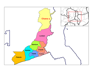
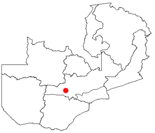
Chama is a small town in the Eastern Province of Zambia, and is headquarters of Chama District. It is one of the most remote district headquarters in the country, lying just inside the eastern edge of the upper Luangwa Rift Valley, at the foot of the highlands dividing Zambia and Malawi. It is served by only one gravel road which comes from Lundazi and the provincial capital of the Eastern Province, Chipata, 300 km to the south. A dirt track connects the town to the South Luangwa National Park 200 km south-west, running parallel to the Luangwa River. A little-used dirt track follows the Malawi border further north and crosses into Isoka District west of the Nyika Plateau. The Road Development Agency is also developing a road from Chama westwards across the Luangwa River to the town of Matumbo, where the road will end at a junction with the T2 Road, Zambia's Great North Road. It is meant to be the 2nd main road out of Chama after the Lundazi-Chipata Route and is meant to provide access for Chama Residents to the headquarters of Muchinga Province, which is Chinsali.

Chiengi or is a historic colonial boma of the British Empire in central Africa and today is a settlement in the Luapula Province of Zambia, and headquarters of Chiengi District. Chiengi is in the north-east corner of Lake Mweru, and at the foot of wooded hills dividing that lake from Lake Mweru Wantipa, and overlooking a dambo stretching northwards from the lake, where the Chiengi rivulet flows down from the hills.

Chilanga is a township located 20 km south of Zambia's capital city, Lusaka. It is situated midway between Lusaka and Kafue on the T2 road.

The Mafinga Hills are a plateau covered by hills, situated on the border between Zambia and Malawi, in Southern Africa. These hills are composed of quartzites, phyllites and feldspathic sandstones of sedimentary origin.

Mambwe District is a district of Zambia, located in Eastern Province. Mambwe District inhabits the Luangwa Valley between the 13th and 14th parallel of south latitude. The Kunda name for this area is "Malambo''.

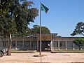 Lundazi Council Building