
Kwai Chung is an urban area within Tsuen Wan New Town in the New Territories of Hong Kong. Together with Tsing Yi Island, it is part of the Kwai Tsing District District of Hong Kong. It is also part of Tsuen Wan New Town.

Moanalua is a valley, a stream, an ahupuaʻa, and a residential neighborhood in Honolulu, Hawaiʻi. The valley extends inland from behind Āliapaʻakai crater to the crest of the Koʻolau Range.

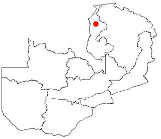
Kasama is a city in the Northern Province of Zambia. It serves as the provincial capital and the headquarters of Kasama District.
Kawambwa is a town in the Zambian province of Luapula located on thedge of the northern Zambian plateau above the Luapula valley at an altitude of 1300 m. It was chosen as an administrative district of the same name by the British colonial authorities who preferred the climate of the plateau rather than the hotter valley where most of the district's population live, and it continues as an administrative district today.
Pyramid Creek Falls Provincial Park is a provincial park in British Columbia, Canada, located on the east side of the North Thompson River between the towns of Blue River (S) and Valemount (N).
The Laughing Whitefish River is a 19.4-mile-long (31.2 km) stream located on the Upper Peninsula of the U.S. state of Michigan. The river rises in eastern Marquette County and flows east and then north through Alger County to its mouth on Lake Superior at 46°31′30″N87°01′43″W a few miles north of Deerton, Michigan. The total watershed of the Laughing Whitefish River is 36 square miles (93 km2).

Gulf of Corcovado is a large body of water separating the Chiloé Island from the mainland of Chile. Geologically, it is a forearc basin that has been carved out by Quaternary glaciers. Most of the islands of Chiloé Archipelago are located in the gulf. The area is next to the Chiloé National Park, and a large population of blue whales is found there, and it is under threat from salmon farming.
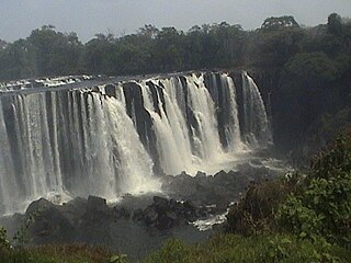
Lumangwe Falls on the Kalungwishi River in northern Zambia is the largest waterfall wholly within that country, with a height of 30-40 m and a width of 160 m. The falls is 80 km from Mporokoso on the Kawambwa road. It has a similar depth of water falling over the edge to the Victoria Falls (Mosi-oa-Tunya) on the Zambezi for which it is frequently mistaken in photographs.
This article gives lists of the National Monuments and other historic sites of Zambia, with a one- or two-line description providing links to details given on other pages.

Murray County was one of the original Nineteen Counties in New South Wales and is now one of the 141 Lands administrative divisions of New South Wales. It included the area which is now part of Canberra and as far north as Lake George and Yass. It was originally bounded on the west by the Murrumbidgee River, on the east by the Shoalhaven River and on the north by the Yass River. A large area of the county was transferred to the Commonwealth government in 1909 in the Seat of Government Acceptance Act to make part of the Australian Capital Territory, along with land in Cowley County. Since then, the ACT border is now part of the western boundary. Part of the ACT border is determined by property boundaries in the Parish of Keewong, in the County of Murray; specifically the southern end of portions 177, 218, 211, 36, and 38. This is mentioned in the Seat of Government Acceptance Act of 1909.
Kabwelume Falls is a waterfall on the Kalungwishi River in the Northern Province of Zambia. The falls is about 6 km down stream of Lumangwe Falls. When viewed at peak water volume (April/May), a month after the wet season, the falls makes a spectacular semi circle of falling water. There are plans to build a hydro power station on this falls.
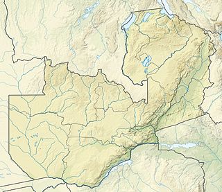
Zambia, officially known as the Republic of Zambia, is a landlocked country in Southern Africa. The neighbouring countries are the Democratic Republic of the Congo to the north, Tanzania to the north-east, Malawi to the east, Mozambique, Zimbabwe, Botswana, and Namibia to the south, and Angola to the west. The capital city is Lusaka, located in the southeast of the country. The population is concentrated mainly around the capital and the Copperbelt to the northwest.

Golden Valley is a small hamlet in Derbyshire, England. It is situated between the larger villages of Codnor and Riddings, and near Ironville and Codnor Park to the east. There was once a road to Ripley, but this is now disused.

North Industry is an unincorporated community in southern Canton Township, Stark County, Ohio, United States, along the Nimishillen Creek. Its altitude is 1,001 feet (305 m). The community is part of the Canton–Massillon Metropolitan Statistical Area. North Industry is often referred to as "Canton South" by the local residents. The mayor of Slabtown is local resident Jeremy Noll.

Landreth Glacier is the steep 2.3 km long and 600 m wide glacier on the southeast side of Imeon Range, Smith Island in the South Shetland Islands, Antarctica, which is draining southeastwards from Mount Foster between the side ridges separating it from Rupite Glacier to the north and Dragoman Glacier to the south, and flowing into Ivan Asen Cove on Bransfield Strait.

Mount Elvire Station was a pastoral lease and sheep station located approximately 177 kilometres (110 mi) south west of Leonora in the Goldfields of Western Australia.
Lusenga Plain National Park is a national park in the Kawambwa District, Luapula Province of Zambia, to the south-east of Lake Mweru.
Manitoba's Porcupine Provincial Forest lies adjacent to the province's western border. The forest has an area of 2,090 km² and is located mostly in an unorganized part of Census Division No. 20, with small parts of it extending southward into the Rural Municipality of Swan River, and eastward into the Rural Municipality of Mountain, both of which are in the same census division.

The Castlereigh Dam is a gravity dam built across the Kehelgamu Oya, a major tributary to the Kelani River, approximately 3 km (1.9 mi) south-west of Hatton, in the Central Province of Sri Lanka.
