
The Kariba Dam is a double curvature concrete arch dam in the Kariba Gorge of the Zambezi river basin between Zambia and Zimbabwe. The dam stands 128 metres (420 ft) tall and 579 metres (1,900 ft) long. The dam forms Lake Kariba, which extends for 280 kilometres (170 mi) and holds 185 cubic kilometres (150,000,000 acre⋅ft) of water.

Zambia, officially the Republic of Zambia, is a landlocked country at the crossroads of Central, Southern and East Africa. It is typically referred to being in South-Central Africa or Southern Africa. It is bordered to the north by Democratic Republic of the Congo, Tanzania to the north-east, Malawi to the east, Mozambique to the southeast, Zimbabwe and Botswana to the south, Namibia to the southwest, and Angola to the west. The capital city of Zambia is Lusaka, located in the south-central part of Zambia. The population is concentrated mainly around Lusaka in the south and the Copperbelt Province to the north, the core economic hubs of the country.

The Zambezi is the fourth-longest river in Africa, the longest east-flowing river in Africa and the largest flowing into the Indian Ocean from Africa. Its drainage basin covers 1,390,000 km2 (540,000 sq mi), slightly less than half of the Nile's. The 2,574-kilometre-long (1,599 mi) river rises in Zambia and flows through eastern Angola, along the north-eastern border of Namibia and the northern border of Botswana, then along the border between Zambia and Zimbabwe to Mozambique, where it crosses the country to empty into the Indian Ocean.

Western Province is one of the 10 provinces in Zambia and encompasses most of the area formerly known as Barotseland. The capital is Mongu, and together with the neighbouring town of Limulunga, Mongu is treated as the capital of Barotseland.

Victoria Falls, popularly known as Vic Falls, is a resort town and city in the province of Matabeleland North, Zimbabwe. It lies on the southern bank of the Zambezi River at the western end of Victoria Falls themselves. According to the 2022 Population Census, the town had a population of 35,199.

Chinyingi is a Capuchin mission and hospital in the sparsely populated North-Western Province of Zambia, on the west bank of the Zambezi River. An estimated 6000 people live within a seven kilometer radius of the Chinyingi mission. The mission's hospital, Chinyingi Mission Hospital, serves the local community with a 52-bed hospital and several health outreach programs, providing everything from first aid to services for people with HIV/AIDS AIDS, which affects some 25% of Zambia's population. The mission also operates a school.
Mwinilunga is a town in the North-Western Province of Zambia. It is the headquarters of Mwinilunga District, one of the province's eleven districts.

Lusaka Province is one of the ten provinces of Zambia. Its capital is Lusaka, which is also the national capital. It is the smallest province in Zambia, with an area of 21,896 km2. Lusaka is also Zambia's most populated and most densely populated province, with a population of 2,191,225 and density of 100 persons per km2 as of 2010. It is the most urban province, with the most doctors and fewest malaria-related incidents. The province is bordered by Zimbabwe and Mozambique, and separated by the Lower Zambezi National Park.

Southern Province is one of Zambia's ten provinces, and home to Zambia's premier tourist attraction, Mosi-oa-Tunya, shared with Zimbabwe. The centre of the province, the Southern Plateau, has the largest area of commercial farmland of any Zambian province, and produces most of the maize crop.
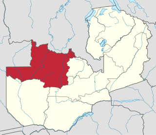
North-Western Province is one of ten Provinces of Zambia. It covers an area of 125,826 km2 (48,582 sq mi), has a population of 727,044 and a population density of 5.80 per square kilometre as of 2010. It is the most sparsely populated province in the country. The provincial capital is Solwezi. The literacy rate stood at 63 per cent against a national average of 70.2 per cent. The rural population constituted 77.45%, while the urban population was 22.55%. North-Western Province is bordered along Angola in the west, the Democratic Republic of Congo in the north, Copperbelt Province in the east, Central in the south-east, and Western Province in the south-west.

The ten provinces of Zambia are divided into a total of 116 districts as of 2018.

The Sakeji School is a school near Kalene Hill in the remote Ikelenge District of north-western Zambia, just north of Mwinilunga. It is a Christian boarding school for primary students. It is mainly intended to serve the children of missionaries in the region, including Zambia, Angola and the Democratic Republic of the Congo, but the school also accepts expatriate and Zambian children.
The following outline is provided as an overview of and topical guide to Zambia:
Zambia, officially known as the Republic of Zambia, is a landlocked country in Southern Africa. The neighbouring countries are the Democratic Republic of the Congo to the north, Tanzania to the north-east, Malawi to the east, Mozambique, Zimbabwe, Botswana, and Namibia to the south, and Angola to the west. The capital city is Lusaka, located in the southeast of the country. The population is concentrated mainly around the capital and the Copperbelt to the northwest.

Shangombo District with headquarters at Shangombo is located in Zambia. As of the 2010 Zambian Census, the district had a population of 84, 070 people. This population is a combined figure with the newly created district of Sioma which was created by halving the primary district. The western part of the half retains the name Shangombo while the eastern part is called Sioma District.
Mutanda is a town in Kalumbila District, North-Western Province, Zambia. It is approximately 33 kilometres (21 mi), by road, southwest of Solwezi. Mutanda is situated approximately 500 kilometres (310 mi), by road, northwest of Lusaka, the capital.
Kalene Hill is a community in the northwest of Zambia near a hill by the same name about 3 kilometres (2 mi) to the southeast. It is part of the Ikelenge District. Kalene Hill was the site of an early medical mission. The hospital is still important to the region.
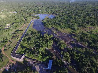
Zengamina is a small hydroelectric power generation plant near Kalene Hill, Ikelenge District in northwestern Zambia. It was built between 2004 and 2008 at a cost of about $3 million, or $4,285 per kilowatt of power.

Ikelenge District is a district of North-Western Province, Zambia. It was separated from Mwinilunga District in 2011.
