Lumangwe Falls

Last updated
Lumangwe falls on the Kalungwishi river during the dry season (September-October) Lumangwe falls on the Kalungwishi river during the dry season(September-October).jpg
Lumangwe falls on the Kalungwishi river during the dry season (September-October)

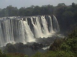
Lumangwe Falls on the Kalungwishi River in northern Zambia is the largest waterfall wholly within the country, with a height of 30-40 m and a width of 100-160 m. [1] [2] It is a block-type waterfall located between the Luapula and Northern Provinces. [3] The main bedrock is interbedded quartzite with layers of red siltstone. [4]

Contents

The falls are 80 km from Mporokoso on the Kawambwa road. It has a similar depth of water falling over the edge to the Victoria Falls (Mosi-oa-Tunya) on the Zambezi for which it is frequently mistaken in photographs. Lumangwe Falls forms part of the Lumangwe Falls / Kabwelume Falls / Chimpepe Falls Complex, a national monument in Zambia. [5]

At the river's height at the end of the rainy season in April / May, spray from the waterfall may be carried 100 m into the air and the roaring sound in the gorge below seems to shake the ground.[ citation needed ]

Lumangwe Falls are reached via a 10 km earth road which turns west from the Kawambwa-Mporokoso gravel road, 2.5 km north-east of the Kalungwishi bridge at Chipempe, which replaced the pontoon (Kalungwishi Ferry) in 2004. The falls can be viewed from the bank of the river at the top and from a cliff almost opposite the drop. Paths lead to the foot of the falls and also down the gorge to Kabwelume Falls 6 km downstream.

The falls have not seen the same level of tourism as the more well-known Victoria Falls. A council planning officer reported to the Zambia Daily Mail that this was because the area was previously sacred to chiefs in the district who would pay homage to their ancestors, and the area was avoided by the common people. Attempts to open the Lumangwe Falls area began in 1975, but were unsuccessful until 1996. This was attributed to the chiefs agreeing to move the ancestral spirits to a different location. [3] The name of the falls comes from a snake spirit, Lumangwe, which is said to have stretched itself between the Lumangwe falls and the Kabwelume Falls, a distance of roughly 5 km.

Ecology

Slightly downstream from Lumangwe Falls is the only known location of the flower Zygotritonia atropurpurea , identified by Peter Goldblatt et al. in 2019. [6]

Related Research Articles

<span class="mw-page-title-main">Zambezi</span> Major river in southern Africa

The Zambezi is the fourth-longest river in Africa, the longest east-flowing river in Africa and the largest flowing into the Indian Ocean from Africa. Its drainage basin covers 1,390,000 km2 (540,000 sq mi), slightly less than half of the Nile's. The 2,574-kilometre-long (1,599 mi) river rises in Zambia and flows through eastern Angola, along the north-eastern border of Namibia and the northern border of Botswana, then along the border between Zambia and Zimbabwe to Mozambique, where it crosses the country to empty into the Indian Ocean.

<span class="mw-page-title-main">Victoria Falls</span> Waterfall on the Zambezi River in Zambia and Zimbabwe

Victoria Falls is a waterfall on the Zambezi River in southern Africa, which provides habitat for several unique species of plants and animals. It is located on the border between Zambia and Zimbabwe and is one of the world's largest waterfalls, with a width of 1,708 m (5,604 ft).

<span class="mw-page-title-main">Lake Mweru</span> Lake in Zambia

Lake Mweru is a freshwater lake on the longest arm of Africa's second-longest river, the Congo. Located on the border between Zambia and Democratic Republic of the Congo, it makes up 110 kilometres (68 mi) of the total length of the Congo, lying between its Luapula River (upstream) and Luvua River (downstream) segments.

This article deals with the disputed area on the borders of the Democratic Republic of the Congo and Zambia, in Luapula Province.

<span class="mw-page-title-main">Lake Mweru Wantipa</span> Lake and swamp system in northern Zambia

Lake Mweru Wantipa or Mweru-wa-Ntipa meaning "muddy lake" is a lake and swamp system in the Northern Province of Zambia. It has been regarded in the past as something of mystery, displaying fluctuations in water level and salinity which were not entirely explained by variation in rainfall levels; it has been known to dry out almost completely. This is compounded by its remoteness and it not receiving the same attention from geographers and geologists as its larger and more accessible neighbours, Lake Tanganyika, 25 km east, and Lake Mweru, 40 km west, with which its name is sometimes confused.

<span class="mw-page-title-main">Northern Province, Zambia</span> Province of Zambia

Northern Province is one of Zambia's ten provinces. It covers approximately one sixth of Zambia in land area. The provincial capital is Kasama. The province is made up of 12 districts, namely Kasama District, Chilubi District, Kaputa District, Luwingu District, Mbala District, Mporokoso District, Mpulungu District, Mungwi District, Nsama District, Lupososhi District, Lunte District and Senga Hill District. Currently, only Kasama and Mbala have attained municipal council status, while the rest are still district councils. It is widely considered to be the heartland of the Bemba, one of the largest tribes in Zambia.

<span class="mw-page-title-main">Kalungwishi River</span>

The Kalungwishi River flows west in northern Zambia into Lake Mweru. It is known for its waterfalls, including the Lumangwe Falls, Kabweluma Falls, Kundabwika Falls and Mumbuluma Falls.

<span class="mw-page-title-main">Kawambwa</span> Place in Luapula Province, Zambia

Kawambwa is a town in the Zambian province of Luapula located on the edge of the northern Zambian plateau above the Luapula valley at an altitude of 1300 m. It was chosen as an administrative district of the same name by the British colonial authorities who preferred the climate of the plateau rather than the hotter valley where most of the district's population live, and it continues as an administrative district today.

<span class="mw-page-title-main">Mansa, Zambia</span> City in Luapula, Zambia

Mansa is the capital of the Luapula Province of Zambia, and headquarters of Mansa District. It takes its name from the local Chief Mansa and the small Mansa River which flows west to the Luapula River. During British rule the city was named Fort Rosebery.

<span class="mw-page-title-main">Luapula Province</span> Province of Zambia

Luapula Province is one of Zambia's ten provinces located in the northern part of the country. Luapula Province is named after the Luapula River and its capital is Mansa. As per the 2010 Zambian census, the Province had a population of 991,927, which accounted for 7.57 per cent of the total Zambian population.

<span class="mw-page-title-main">Kazembe</span>

Kazembe is a traditional kingdom in modern-day Zambia, and southeastern Congo. For more than 250 years, Kazembe has been an influential kingdom of the Kiluba-Chibemba, speaking the language of the Eastern Luba-Lunda people of south-central Africa. Its position on trade routes in a well-watered, relatively fertile and well-populated area of forestry, fishery and agricultural resources drew expeditions by traders and explorers who called it variously Kasembe, Cazembe and Casembe.

Kazembe is a name used for Mwata Kazembe's town in the Luapula Province of Zambia, especially on maps and in the Zambian postal service. The other name for the town is Mwansabombwe and this is the one used by its or Luba or Chibemba-speaking inhabitants. They may refer in English to "Kazembe's Village" or just "Kazembe", as traditionally a settlement is named after the chief or headman, rather than the location. The Luba-Lunda shared with many tribes the custom of moving to another village or a new site on the death of the chief. Historical references to a village or town may actually be to a different location. For instance when the explorer David Livingstone visited Mwata Kazembe in 1867 and 1868, "Casembe's town", as he wrote it, was further north at the town now called Kanyembo.

Ntumbachushi Falls are situated on the Ngona River in Luapula Province, Zambia where it runs over the edge of the northern Zambian plateau into the valley of the Luapula River.

This article gives lists of the National Monuments and other historic sites of Zambia, with a one- or two-line description providing links to details given on other pages.

Kabwelume Falls is a waterfall on the Kalungwishi River in the Northern Province of Zambia. The falls is about 6 km down stream of Lumangwe Falls. When viewed at peak water volume (April/May), a month after the wet season, the falls makes a spectacular semi circle of falling water. There are plans to build a hydro power station on this falls.

<span class="mw-page-title-main">Chiengi</span> Place in Luapula Province, Zambia

Chiengi or is a historic colonial boma of the British Empire in central Africa and today is a settlement in the Luapula Province of Zambia, and headquarters of Chiengi District. Chiengi is in the north-east corner of Lake Mweru, and at the foot of wooded hills dividing that lake from Lake Mweru Wantipa, and overlooking a dambo stretching northwards from the lake, where the Chiengi rivulet flows down from the hills.

<span class="mw-page-title-main">Outline of Zambia</span> Overview of and topical guide to Zambia

The following outline is provided as an overview of and topical guide to Zambia:

Zambia, officially known as the Republic of Zambia, is a landlocked country in Southern Africa. The neighbouring countries are the Democratic Republic of the Congo to the north, Tanzania to the north-east, Malawi to the east, Mozambique, Zimbabwe, Botswana, and Namibia to the south, and Angola to the west. The capital city is Lusaka, located in the southeast of the country. The population is concentrated mainly around the capital and the Copperbelt to the northwest.

Lusenga Plain National Park is a national park in the Kawambwa District, Luapula Province of Zambia, to the south-east of Lake Mweru.

The M3 road is a road in northern Zambia that connects Kasama in the Northern Province with the Congo Pedicle border at Chembe in the Luapula Province via Luwingu and Mansa. The road contains two tollgates between Kasama and Mansa.

References

  1. "Lumangwe Falls". Zambia Tourism. Retrieved 2022-02-16.
  2. "Lumangwe Falls - The Largest Waterfall Entirely in Zambia". World of Waterfalls. Retrieved 2022-02-16.
  3. 1 2 "Lumangwe Falls: Uncovering Luapula's hidden beauty". Zambia Daily Mail. 6 August 2017. Retrieved 16 February 2022.
  4. Olivotos, Spiros; Niedermann, Samuel; Flügel, Tyrel; Mouslopoulou, Vasiliki; Merchel, Silke; Cotterill, Fenton; Bookhagen, Bodo; Gärtner, Andreas; Rugel, Georg; Scharf, Andreas; Nadeau, Marie-Josée (2021-05-15). "Quaternary landscape evolution in a tectonically active rift basin (paleo-lake Mweru, south-central Africa)". Geomorphology. 381: 107669. doi:10.1016/j.geomorph.2021.107669. hdl: 11250/2980842 . ISSN   0169-555X. S2CID   233907951.
  5. Mwamulowe, Kagosi; Nyambe, Imasiku Anayawa (2021), Singh, R.B.; Wei, Dongying; Anand, Subhash (eds.), "The Use of Geoheritage, Geopark and Geotourism Concepts to Conserve and Sustain Tourism Development in Zambia", Global Geographical Heritage, Geoparks and Geotourism: Geoconservation and Development, Advances in Geographical and Environmental Sciences, Singapore: Springer, pp. 381–405, doi:10.1007/978-981-15-4956-4_20, ISBN   978-981-15-4956-4, S2CID   228872242 , retrieved 2022-02-16
  6. Goldblatt, P.; Manning, J. C.; Wightman, N.; McCleland, W. (2019-08-01). "Zygotritonia atropurpurea (Iridaceae: Crocoideae), a new local endemic species from northern Zambia of this small tropical African genus". South African Journal of Botany. 124: 20–22. doi: 10.1016/j.sajb.2019.04.016 . ISSN   0254-6299. S2CID   182781330.

9°32′S29°23′E / 9.533°S 29.383°E / -9.533; 29.383