
Malawi is a landlocked country in southeast Africa. It is wholly within the tropics; from about 9°30S at its northernmost point to about 17°S at the southernmost tip. The country occupies a thin strip of land between Zambia and Mozambique, extending southwards into Mozambique along the valley of the Shire River. In the north and north east it also shares a border with Tanzania. Malawi is connected by rail to the Mozambican ports of Nacala and Beira. It lies between latitudes 9° and 18°S, and longitudes 32° and 36°E.

The Zambezi is the fourth-longest river in Africa, the longest east-flowing river in Africa and the largest flowing into the Indian Ocean from Africa. Its drainage basin covers 1,390,000 km2 (540,000 sq mi), slightly less than half of the Nile's. The 2,574 km (1,599 mi) river rises in Zambia and flows through eastern Angola, along the north-eastern border of Namibia and the northern border of Botswana, then along the border between Zambia and Zimbabwe to Mozambique, where it crosses the country to empty into the Indian Ocean.

Victoria Falls is a waterfall on the Zambezi River in southern Africa, which provides habitat for several unique species of plants and animals. It is located on the border between Zambia and Zimbabwe and is one of the world's largest waterfalls, with a width of 1,708 m (5,604 ft).
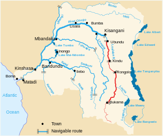
The Lualaba River flows entirely within the eastern part of Democratic Republic of the Congo. It provides the greatest streamflow to the Congo River, while the source of the Congo is recognized as the Chambeshi. The Lualaba is 1,800 kilometres (1,100 mi) long. Its headwaters are in the country's far southeastern corner near Musofi and Lubumbashi in Katanga Province, next to the Zambian Copperbelt.

The Luapula River is a north-flowing river of central Africa, within the Congo River watershed. It rises in the wetlands of Lake Bangweulu (Zambia), which are fed by the Chambeshi River. The Luapula flows west then north, marking the border between Zambia and the Democratic Republic of the Congo before emptying into Lake Mweru. The river gives its name to Zambia's Luapula Province.
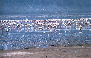
The Rift Valley lakes are a series of lakes in the East African Rift valley that runs through eastern Africa from Ethiopia in the north to Malawi in the south, and includes the African Great Lakes in the south. These include some of the world's oldest lakes, deepest lakes, largest lakes by area, and largest lakes by volume. Many are freshwater ecoregions of great biodiversity, while others are alkaline "soda lakes" supporting highly specialised organisms.

The Nizhnyaya Tunguska is a river in Siberia, Russia, that flows through the Irkutsk Oblast and the Krasnoyarsk Krai. The river is a right tributary of the Yenisey joining it at Turukhansk. The ice-free period on the Nizhnyaya Tunguska starts in mid-June and ends in the first half of October. The river forms the western limit of the Lena Plateau.

The Luangwa River is one of the major tributaries of the Zambezi River, and one of the four biggest rivers of Zambia. The river generally floods in the rainy season and then falls considerably in the dry season. It is one of the biggest unaltered rivers in Southern Africa and the 52,000 square kilometres (20,000 sq mi) that make up the surrounding valley are home to abundant wildlife.

The Kafue River is the longest river lying wholly within Zambia at about 1,576 kilometres (979 mi) long. Its water is used for irrigation and for hydroelectric power. It is the largest tributary of the Zambezi, and of Zambia's principal rivers, it is the most central and the most urban. More than 50% of Zambia's population live in the Kafue River Basin and of these around 65% are urban.

Kafue is a town on the T2 road in the Lusaka Province of Zambia and it lies on the north bank of the Kafue River, after which it is named. It is the southern gateway to the central Zambian plateau on which Lusaka and the mining towns of Kabwe and the Copperbelt are located.

The Crowe River is a river in the counties of Haliburton, Hastings, Northumberland and Peterborough in southern Ontario, Canada. It is in the Lake Ontario drainage basin and is a tributary of the Trent River.
The Chambal River is a tributary of the Yamuna River in Central and Northern India, and thus forms part of the drainage system of the Ganges. The river flows north-northeast through Madhya Pradesh, running for a time through Rajasthan, then forming the boundary between Rajasthan and Madhya Pradesh before turning southeast to join the Yamuna in Uttar Pradesh state.

Periyar, IPA:[peɾijɐːr], is the longest river and the river with the largest discharge potential in the Indian state of Kerala. It is one of the few perennial rivers in the region and provides drinking water for several major towns. The Periyar is of utmost significance to the economy of Kerala. It generates a significant proportion of Kerala's electrical power via the Idukki Dam and flows along a region of industrial and commercial activity. The river also provides water for irrigation and domestic use throughout its course besides supporting a rich fishery. Due to these reasons, the river has been named the "Lifeline of Kerala". Kochi city, in the vicinity of the river mouth, draws its water supply from Aluva, an upstream site sufficiently free of seawater intrusion. Twenty five percent of Kerala's industries are along the banks of the Periyar. These are mostly crowded within a stretch of 5 kilometres (3 mi) in the Eloor-Edayar region (Udhyogamandal), about 10 kilometres (6 mi) north of Kochi harbor.

South Luangwa National Park is in eastern Zambia, the southernmost of three national parks in the valley of the Luangwa River. It is a world-renowned wildlife haven which is known to locals simply as "the South Park." Concentrations of game along the meandering Luangwa River and its lagoons are amongst the most intense in Africa. The river teems with hippo and crocodile and provides a lifeline for one of the greatest diversities of habitat and wildlife, supporting more than 60 species of mammals and over 400 species of birds. It marks the end of the Great Rift Valley.

The Great East Road is a major road in Zambia and the main route linking its Eastern Province with the rest of the country. It is also the major link between Zambia and Malawi and between Zambia and northern Mozambique. However, the route does not carry as much traffic as many of the other regional arterial roads and between the main cities it serves, Lusaka and Chipata, it passes through rural and wilderness areas. In Lusaka the road forms the main arterial road for the eastern suburbs. The entire route from Lusaka to Chipata and the border with Malawi is designated the T4 road on Zambia's road network.

The Wadi Mujib, also known as Arnon Stream, is a river in Jordan. The river empties into the Dead Sea circa 420 metres (1,380 ft) below sea level.

The Mulungushi River in central Zambia is a tributary of the Lunsemfwa River and a part of the Zambezi River basin. It rises on the plateau north-west of Kabwe and flows south-east into the Luangwa Rift Valley where it joins the Lunsemfwa.

The wildlife of Zambia refers to the natural flora and fauna of Zambia. This article provides an overview, and outline of the main wildlife areas or regions, and compact lists of animals focusing on prevalence and distribution in the country rather than on taxonomy. More specialized articles on particular groups are linked from here.
The biomes and ecoregions in the ecology of Zambia are described, listed and mapped here, following the World Wildlife Fund's classification scheme for terrestrial ecoregions, and the WWF freshwater ecoregion classification for rivers, lakes and wetlands. Zambia is in the Zambezian region of the Afrotropical biogeographic realm. Three terrestrial biomes are well represented in the country . The distribution of the biomes and ecoregions is governed mainly by the physical environment, especially climate.
The Alb is a river in the southern Black Forest. It arises from two headwaters, the Menzenschwander Alb and Bernauer Alb, and flows in a southerly direction. It ends after 43.6 kilometres (27.1 mi) at a confluence with the High Rhine at Albbruck.
