Following floods in 2024, the River Ngadabul in Maiduguri, Borno State, reportedly yielded no fewer than 15 bodies, according to the National Emergency Management Agency,[5] NEMA. This was confirmed by Muhammad Usman, the NEMA North East Coordinator, in an interview with the News Agency of Nigeria (NAN) in Maiduguri.[6]
Pollution
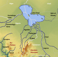
The Ngadda River receives all sorts of waste from residential houses, it is also contaminated with metal pollutants. River Ngadda is a significant waterway inside Maiduguri city. Its fields and banks are known to have various activities and assets. At the point when the waterway spills over its shores, adjoining other neighboring, lands could face obliteration, and there could be loss of lives and properties when these occurs.[7]
↑ Thambyapillay, G. G. R. (1993-05-13). "Drought chronology dating in the lake Chad basin (Nigeria command)". Colloques et séminaires - Institut français de recherche scientifique pour le développement en coopération. Paris: ORSTOM Soil Research Centre: 31–61.
This page is based on this Wikipedia article Text is available under the CC BY-SA 4.0 license; additional terms may apply. Images, videos and audio are available under their respective licenses.