Lake Chad replenishment project

Last updated

The Lake Chad replenishment project is a proposed major water diversion scheme to divert water from the Congo River basin to Lake Chad to prevent it drying up. Various versions have been proposed. Most would involve damming some of the right tributaries of the Congo River and channeling some of the water to Lake Chad via a canal to the Chari River basin. [1]

Contents

It was first proposed in 1929 by Herman Sörgel as part of his Atlantropa project, as a way to irrigate the Sahara. In the 1960s, Lake Chad began to shrink, and the idea was revived as a solution to that problem.

The members of the Lake Chad Basin International Commission are Chad, the Central African Republic, Nigeria, Cameroon and Niger. Concerned by shrinkage of the lake's area from 20,000 square kilometres (7,700 sq mi) in 1972 to 2,000 square kilometres (770 sq mi) in 2002, they met in January 2002 to discuss the project. Both the ADB[ clarification needed ] and the Islamic Development Bank expressed interest in the project. However, the member states of the Congo-Ubangi-Sangha Basin International Commission (Congo-Kinshasa, Congo-Brazzaville and the Central African Republic) expressed concern that the project would reduce the energy potential of the Inga hydroelectric dam, would affect navigation on the Ubangi and Congo rivers and would reduce fish catches on these rivers. [2] However, even the largest proposals would divert less than 8% of the Congo's water, while the remaining 92-95% would not only reach Inga, but would produce electricity twice, first at the new dams and eventually at Inga.

In 2011, the Canadian firm CIMA, under contract from Lake Chad Basin Commission, produced a feasibility study of several versions of the project. [3]

Pumping from Ubangi

There are several proposals to divert water from the Ubangi River, the biggest tributary of the Congo. This requires pumping the water some 180 m uphill, so it requires a power source, either hydroelectric or solar. The CIMA study considered a version using a dam on the Ubangi to generate 360 MW of power, 250 MW of which would be used to pump water. It was estimated to deliver 91 m3/s of water to the Chari at a cost of $10 billion. [3]

A variant of this idea would pump water from the Ubangi using solar power instead of hydroelectric power, to avoid the expense and disruption of a dam. [4]

Damming Kotto

The CIMA feasibility study also considered diverting water from a dam on the Kotto River, a tributary of the Ubangi, near Bria. This is high enough to move water to the Chari by gravity, with no pumping needed. It was estimated to deliver 108 m3/s at a cost of $4.5 billion. [3]

Transaqua

Transaqua (in red). Transaqua.svg
Transaqua (in red).

The most ambitious proposal, named Transaqua, [5] was proposed by a team of engineers of the firm Bonifica. [6] [7] led by Dr. Marcello Vichi, [8] It would dam not only the Kotto but also the other right tributaries to the south, including the much larger Mbomou, Uele and Aruwimi. The water would be carried north by a 2400 km navigable canal along a contour line, which would generate hydro-electricity at several points along its length. These would power new industrial townships, while the canal would replenish the lake. [9] The total water delivered would be more than 1500 m3/s, which is 5-8% of the Congo's average flow, and more than the current total inflow to Lake Chad. But the cost would be more than $50 billion.

This plan was initially considered unlikely to materialize as late as 2005. [10] It was rejected in favor of a smaller water-transfer scheme from the Ubangi. The Lake Chad Basin Commission, however, judged that the project, which involved pumping water upwards from the Ubangi River, was not sufficient to replenish Lake Chad, and adopted Transaqua as the "only feasible" project at the International Conference on Lake Chad, on 26–28 Feb. 2018. [11] [12]

Following the ICLC, representatives of the LCBC and the Italian government signed a MoU for initial funding for the Transaqua feasibility study on 16 October 2018. [13]

On 16 December 2019, an amendment introduced by Italian Sen. Tony Iwobi to the 2021 Italian budget law included a financing of 1.5 million Euro for the feasibility study. [14]

On 13 November 2020, Former Italian Prime Minister, former EU Commission chief and former UN Special Envoy for the Sahel Romano Prodi stated that the populations around Lake Chad could not wait any longer and called for the EU, the UNO, the Organization for African Unity and China to join hands to finance and build Transaqua. [15]

A large merit for the success of Transaqua has been attributed to activists from the LaRouche movement. [16] [17]

Alternative inland waterway

Congo River, inland navigation system. Lualaba River DRC.svg
Congo River, inland navigation system.
The drainage basin of the Congo River. Congobasinmap.png
The drainage basin of the Congo River.

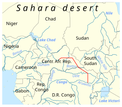
In addition to moving water, this proposal would create an inland waterway from the Ubangi River to the Chari River), around 366 km channel, from the Gigi River (close to DjoukouGalabadja in Kémo), through Sibut, Bouca and then to Batangafo (over the Boubou River and into the Ouham River and then the Chari River).

This path is the same one used by the CIMA study (water flow 100 m3/s, the same as the Moscow Canal), only sizing the channel and adapting the river and locks to support ships.

Chad-Congo inland waterway

This waterway could link Lake Chad with the Congo River inland navigation system and the waterway transport in the Democratic Republic of the Congo.

The navigable waterway system in Congo can be upgraded from Kinshasa to Matadi sea port, already planned as an option in the Inga dams project.

As well as it is "feasible" from Lake Mweru (Pweto city) through Luvua River to Ankoro (requiring dams and a Boat lift in Boyoma Falls, like the Three Gorges dam ship lift), or the waterway into the Lake Tanganyika in Kalemie through the Lukuga River up to Kabalo (Zanza village), now linked by railway.

Comparison to other channels

A 366 km (227 mi) channel from the Ubangi to Chari would travel double the distance of the 171 km (106 mi) Rhine–Main–Danube Canal, three times the 128 km (80 mi) Moscow Canal or the 101 km (63 mi) Volga–Don Canal, or about the same length as the 368 km (229 mi) Volga–Baltic Waterway (that forms part of the Unified Deep Water System of European Russia). It would be five times shorter than China's 1,776 km (1,104 mi) Grand Canal (built during the Sui dynasty) and ten times shorter than the entire 3,770 km (2,340 mi) Saint Lawrence Seaway and Great Lakes Waterway (waterway from Duluth, Minnesota, to the Atlantic Ocean).

Related Research Articles

<span class="mw-page-title-main">Geography of Chad</span> African country

Chad is one of the 47 landlocked countries in the world and is located in North Central Africa, measuring 1,284,000 square kilometers (495,755 sq mi), nearly twice the size of France and slightly more than three times the size of California. Most of its ethnically and linguistically diverse population lives in the south, with densities ranging from 54 persons per square kilometer in the Logone River basin to 0.1 persons in the northern B.E.T. (Borkou-Ennedi-Tibesti) desert region, which itself is larger than France. The capital city of N'Djaména, situated at the confluence of the Chari and Logone Rivers, is cosmopolitan in nature, with a current population in excess of 700,000 people.

<span class="mw-page-title-main">Congo River</span> River in central Africa

The Congo River, formerly also known as the Zaire River, is the second-longest river in Africa, shorter only than the Nile, as well as the third-largest river in the world by discharge volume, following the Amazon and Ganges rivers. It is the world's deepest recorded river, with measured depths of around 220 m (720 ft). The Congo-Lualaba-Chambeshi River system has an overall length of 4,700 km (2,900 mi), which makes it the world's ninth-longest river. The Chambeshi is a tributary of the Lualaba River, and Lualaba is the name of the Congo River upstream of Boyoma Falls, extending for 1,800 km (1,100 mi).

<span class="mw-page-title-main">Lake Chad</span> Lake in Central Africa

Lake Chad is an endorheic freshwater lake located at the junction of four countries: Nigeria, Niger, Chad, and Cameroon in western and central Africa respectively. It is also an important wetland ecosystem in West-Central Africa. The catchment area of Lake Chad is 1 million square kilometres (390,000 sq mi). In the 19th century, Lake Chad was substantially larger with an area of 28,000 square kilometres (11,000 sq mi). However, due to climate change and human water diversion, Lake Chad has been greatly reduced since the mid-1970s, and its area has fluctuated between 2,000 and 5,000 square kilometres.

<span class="mw-page-title-main">Ubangi River</span> Tributary of the Congo River

The Ubangi River, also spelled Oubangui, is the largest right-bank tributary of the Congo River in the region of Central Africa. It begins at the confluence of the Mbomou and Uele Rivers and flows west, forming the border between Central African Republic (CAR) and Democratic Republic of the Congo. Subsequently, the Ubangi bends to the southwest and passes through Bangui, the capital of the CAR, after which it flows south – forming the border between Democratic Republic of the Congo and Republic of the Congo. The Ubangi finally joins the Congo River at Liranga.

<span class="mw-page-title-main">Ubangi-Shari</span> 1903–1960 French colony in Central Africa, now the Central African Republic

Ubangi-Shari was a French colony in central Africa, a part of French Equatorial Africa.

<span class="mw-page-title-main">Chari River</span> River in Central Africa

The Chari River, or Shari River, is a 1,400 kilometres (870 mi) long river, flowing in Central Africa. It is Lake Chad's main source of water.

<span class="mw-page-title-main">Postage stamps and postal history of Ubangi-Shari</span>

Ubangi-Shari was a French colony in central Africa which later became the independent country of the Central African Republic on August 13, 1960. It followed the establishment of the Bangui outpost in 1889, and was named in 1894.

<span class="mw-page-title-main">Logone River</span> River in Chad, Cameroon

The Logon or Logone River is a major tributary of the Chari River. The Logone's sources are located in the western Central African Republic, northern Cameroon, and southern Chad. It has two major tributaries: the Pendé River in the prefecture Ouham-Pendé in the Central African Republic and the Mbéré River at the east of Cameroon. Many swamps and wetlands surround the river.

<span class="mw-page-title-main">Delta–Mendota Canal</span> Aqueduct in Central California

The Delta–Mendota Canal is a 117-mile-long (188 km) aqueduct in central California, United States. The canal was designed and completed in 1951 by the U.S. Bureau of Reclamation as part of the Central Valley Project. It carries freshwater to replace San Joaquin River water which is diverted into the Madera Canal and Friant-Kern Canal at Friant Dam.

<span class="mw-page-title-main">Colorado–Big Thompson Project</span> Federal water diversion project

The Colorado–Big Thompson Project is a federal water diversion project in Colorado designed to collect West Slope mountain water from the headwaters of the Colorado River and divert it to Colorado's Front Range and plains. In Colorado, approximately 80% of the state's precipitation falls on the West Slope, in the Rocky Mountains, while around 80% of the state's growing population lives along the eastern slope, between the cities of Fort Collins and Pueblo.

<span class="mw-page-title-main">Indian rivers interlinking project</span> Project to interlink rivers of India

The Indian Rivers Inter-link is a proposed large-scale civil engineering project that aims to effectively manage water resources in India by linking Indian rivers by a network of reservoirs and canals to enhance irrigation and groundwater recharge, reduce persistent floods in some parts and water shortages in other parts of India. India accounts for 18% of the world population and about 4% of the world's water resources. One of the solutions to solve the country's water woes is to link rivers and lakes.

<span class="mw-page-title-main">Postage stamps and postal history of Chad</span>

This is a survey of the postage stamps and postal history of Chad.

<span class="mw-page-title-main">Ujjani Dam</span> Dam in Madha Taluka, Solapur district

Ujjani Dam, also known as Bhima Dam or Bhima Irrigation Project, on the Bhima River, a tributary of the Krishna River, is an earthfill cum Masonry gravity dam located near Ujjani village of Madha Taluk in Solapur district of the state of Maharashtra in India.

The Central Utah Project is a US federal water project that was authorized for construction under the Colorado River Storage Project Act of April 11, 1956, as a participating project. In general, the Central Utah Project develops a portion of Utah's share of the yield of the Colorado River, as set out in the Colorado River Compact of 1922.

<span class="mw-page-title-main">Interbasin transfer</span>

Interbasin transfer or transbasin diversion are terms used to describe man-made conveyance schemes which move water from one river basin where it is available, to another basin where water is less available or could be utilized better for human development. The purpose of such water resource engineering schemes can be to alleviate water shortages in the receiving basin, to generate electricity, or both. Rarely, as in the case of the Glory River which diverted water from the Tigris to Euphrates River in modern Iraq, interbasin transfers have been undertaken for political purposes. While ancient water supply examples exist, the first modern developments were undertaken in the 19th century in Australia, India and the United States, feeding large cities such as Denver and Los Angeles. Since the 20th century many more similar projects have followed in other countries, including Israel and China, and contributions to the Green Revolution in India and hydropower development in Canada.

The Lake Chad Basin Commission is an intergovernmental organization that oversees water and other natural resource usage in the basin. There are eight member governments—i.e., Cameroon, Chad, Niger, Nigeria, Algeria, the Central African Republic, Libya, and Sudan—chosen for their proximity to Lake Chad.

<span class="mw-page-title-main">Grand Inga Dam</span> Proposed hydro power generation complex in the Democratic Republic of the Congo

The Grand Inga Dam is a series of seven proposed hydroelectric power stations at the site of the Inga Falls, in the Democratic Republic of the Congo. If built as planned, the 40-70 GW project would be the largest power station in the world.

<span class="mw-page-title-main">Chad Basin</span> Largest endorheic basin in Africa

The Chad Basin is the largest endorheic basin in Africa, centered approximately on Lake Chad. It has no outlet to the sea and contains large areas of semi-arid desert and savanna. The drainage basin is approximately coterminous with the sedimentary basin of the same name, but extends further to the northeast and east.

<span class="mw-page-title-main">Ferdinand de Béhagle</span>

Jean Jacques Marie Ferdinand de Béhagle was a French explorer of Africa. He served with the colonial service in Algeria and travelled in the Congo and Ubangi region. While attempting to find a viable land route from the Congo to the Mediterranean via Chad he was taken prisoner by Rabih az-Zubayr and hanged.

References

  1. Abiodun Alao (2007). Natural resources and conflict in Africa: the tragedy of endowment. University Rochester Press. p. 323k. ISBN   978-1-58046-267-9.
  2. Europa Publications Limited (2002). Africa South of the Sahara 2003. Routledge. p. 266. ISBN   1-85743-131-6.
  3. 1 2 3 CIMA International (November 2011). "Feasibility study of the water transfer project from the Ubangi to Lake Chad" (PDF). Archived from the original (PDF) on 25 April 2022. Retrieved 18 July 2021.
  4. Guy Immega (26–28 February 2018). "Ubangi – Lake Chad Water Transfer Using Solar Option". Archived from the original on 7 July 2022. Retrieved 5 May 2020.
  5. "Transaqua Progetto Interafrica". transaquaproject.it. Retrieved 1 December 2020.
  6. Ross, Will (31 March 2018). "Can the vanishing lake be saved?" . Retrieved 28 January 2019.
  7. "Bonifica SpA". bonificagroup.com. Renardet SA. Retrieved 1 December 2020.
  8. "La storia del progetto". transaquaproject.it. Transaqua Project. Retrieved 1 December 2020.
  9. Graham Chapman, Kathleen M. Baker (1992). The Changing geography of Africa and the Middle East. Routledge. p. 56. ISBN   0-415-05710-8.
  10. Michele L. Thieme (2005). Freshwater ecoregions of Africa and Madagascar: a conservation assessment. Island Press. p. 195. ISBN   1-55963-365-4.
  11. Celani, Claudio (9 March 2018). "Conference on Lake Chad Is Historic Breakthrough for Development of Africa" (PDF). larouchepub.com. EIR News Service Inc. Retrieved 1 December 2020.
  12. "Nigeria: une "déclaration d'Abuja" pour tenter de sauver le lac Tchad". Radio France Internationale. 1 March 2018. Retrieved 1 December 2020.
  13. "Commission du Bassin du Lac Tchad". cblt.org. La Commission du Bassin du Lac Tchad. Retrieved 1 December 2020.
  14. Iwobi, Tony Chike (16 December 2019). "Proposta di modifica n. 101.0.37 (testo 2) al DDL n. 1586". senato.it. Senato della Repubblica Italiana. Retrieved 1 December 2020.
  15. Live Roundtable on the Lake Chad: the diplomatic dialogue on YouTube
  16. Lawton, P.D. (18 October 2020). "Green Power, Political Pessimism and Opposition to the Development of the African Interior with Transaqua". africanagenda.net. Retrieved 1 December 2020.
  17. Sayan, Ramazan Caner; Nagabhatla, Nidhi; Ekwuribe, Marvel (2020). "Soft Power, Discourse Coalitions, and the Proposed Interbasin Water Transfer Between Lake Chad and the Congo River". water-alternatives.org. Water Alternatives. Retrieved 1 December 2020.