Mbaïki is the capital of Lobaye, one of the 14 prefectures of the Central African Republic. It is situated in the southwest of the country, 107 km from the capital Bangui. Lobaye people and Pygmy people live in the area. There is also a waterfall near the town.

Bambari is a town in the Central African Republic, lying on the Ouaka River. It has a population of 41,356 and is the capital of Ouaka prefecture. Bambari is an important market town and home to Bambari Airport, and the Roman Catholic Diocese of Bambari.

Kaga-Bandoro is a market town and capital of the Nana-Grébizi prefecture of the Central African Republic. It represents the seat of the Roman Catholic Diocese of Kaga–Bandoro. The town has been renamed twice.

Bangassou is a city in the south eastern Central African Republic, lying on the north bank of the Mbomou River. It has a population of 24,447 and is the capital of the Mbomou prefecture. It is known for its wildlife, market, and nearby Bangassou Airport and is linked by ferry to the Democratic Republic of Congo on the south bank. The city is also home to the Roman Catholic Diocese of Bangassou.

Bouar is a market town in the western Central African Republic, lying on the main road from Bangui (437 km) to the frontier with Cameroon (210 km). The city is the capital of Nana-Mambéré prefecture, has a population of 40,353, while the whole sous-préfecture has a population of 96,595. Bouar lies on a plateau almost 1000m above sea level and is known as the site of Camp Leclerc, a French military base.
N'Délé or Ndele is a market town and sub prefecture in the north eastern Central African Republic, lying east of the Bamingui-Bangoran National Park. Ndélé is the capital of Bamingui-Bangoran, one of the 16 prefectures of the Central African Republic. N'Délé had a population of 10,850 as of the 2003 census; and a calculated 2013 population of 13,704.
Bimbo is located 25.5 kilometres (15.8 mi) by road southwest of the centre of the capital, Bangui. The country's second-largest city, Bimbo had a population of 124,176 as of the 2003 census and a calculated 2013 population of 267,859. Bimbo used to be the capital city of Ombella-M'Poko until December 2020. Since December 2020, Bimbo has been part of Bangui Prefecture.

Bossangoa is the capital of Ouham, one of the 14 prefectures of the Central African Republic. The town has a population of 36,478. It is located 303 km (189 mi) north of the country's capital, Bangui. The Ouham River passes through Bossangoa and on through a number of waterfalls east of the city before turning north to join the Chari River in Chad.

Bozoum is the capital of Ouham-Pendé, one of the 14 prefectures of the Central African Republic.

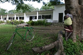
Boda is a town located in the Central African Republic prefecture of Lobaye.

Nola is the capital of Sangha-Mbaéré, an economic prefecture of the Central African Republic. It is located at the confluence of the Kadéï and the Mambere river. The Sangha River is formed here due to the aforementioned rivers.
Gambo is a town located in the Central African Republic prefecture of Mbomou. The town is named after Gambo, a Nzakara chief who ruled the area in the years before 1931.
Mongoumba is a town located in the Lobaye Prefecture, Central African Republic. From 1905–1933, Mongoumba was part of Moyen-Congo.
Kembé is a town located in the Central African Republic prefecture of Basse-Kotto. The Kotto Falls double waterfall is nearby.
Paoua is a town located in the Central African Republic prefecture of Lim-Pendé.The town is the birthplace of the former president of the Central African Republic, Ange-Félix Patassé and mathematician, Gaston Nguérékata.
Yalinga is a town and sub-prefecture in the Haute-Kotto prefecture of the central-eastern Central African Republic.
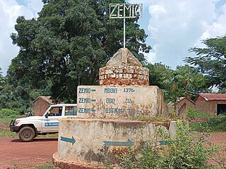
Zemio is a town and sub-prefecture in the Haut-Mbomou prefecture of the south-eastern Central African Republic. Zemio was the former capital of the Sultanate of Zemio before it was abolished in 1923 by France.

Djemah is a town and sub-prefecture in the Haut-Mbomou Prefecture of the south-eastern Central African Republic. It is the least-populous sub-prefecture in the country. The town is largely neglected by the central government since the country gained independence from France in 1960.

Markounda, formerly Fort-Brusseaux, is a sub-prefecture and town in the Ouham Prefecture of the north-western Central African Republic. The sub-prefecture borders with Chad.
Ndjoukou is a sub-prefecture of Kémo in the Central African Republic.

