Haute-Kotto is one of the 20 prefectures of the Central African Republic. Its capital is Bria. It is the largest prefecture in the Central African Republic. In 2024, official estimates suggest the population reached 144,289 inhabitants.

Mbomou is one of the twenty prefectures of the Central African Republic. It covers an area of 61,150 square kilometres (23,610 sq mi) and has a population of 164,009. The capital is Bangassou. Nearby are the Kembe Falls on the River Kotto. The prefecture is governed by Pierrette Benguere. In 2024, official estimates suggest the population reached 267,647 inhabitants.
Mobaye is a settlement with a population of 7,176 in the Basse-Kotto prefecture of Central African Republic. It lies on the Ubangi River.

Bouar is a market town in the western Central African Republic, lying on the main road from Bangui (437 km) to the frontier with Cameroon (210 km). The city is the capital of Nana-Mambéré prefecture, has a population of 40,353, while the whole sous-préfecture has a population of 96,595. Bouar lies on a plateau almost 1000m above sea level and is known as the site of Camp Leclerc, a French military base.

Kabo is a town in the northern Central African Republic, lying north west of Kaga Bandoro. It is a market town and the border post for Chad.

Alindao is a town and sub-prefecture located in the Central African Republic prefecture of Basse-Kotto. It lies at the junction of the National Route 2 and 22. Alindao had a population of 14,401 as of the 2003 census; and a calculated 2013 population of 15,213. The town is the seat of the Roman Catholic Diocese of Alindao. It has a small airport, Alindao Airport. A Catholic Mission was established at Alindao during French occupation under French Equatorial Africa.
Ouadda is a town located in the Central African Republic prefecture of Haute-Kotto.
Bakouma is a sub-prefecture in the prefecture of Mbomou in Central African Republic. The area is known for its prosperity of mineral resources which have for a long time remained unexploited.
Ouanda Djallé is a sub-prefecture and town in the prefecture of Vakaga in the Central African Republic. It is located 130 km south of Birao. By population it is one of the smallest sub-prefectures in the country.

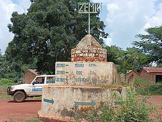
Zemio is a town and sub-prefecture in the Haut-Mbomou prefecture of the south-eastern Central African Republic. Zemio was the former capital of the Sultanate of Zemio before it was abolished in 1923 by France.
Bambouti is a sub-prefecture of Haut-Mbomou in the Central African Republic. The town is abandoned by the country.
Sam Ouandja is a town located in the Central African Republic prefecture of Haute-Kotto near the border with Sudan. It has historically served as important arms trafficking hub for armed groups in Central African Republic. Artisanal diamond mining is also active in the commune.

Mboki is a town and sub-prefecture in the Haut-Mbomou prefecture of the south-eastern Central African Republic.

Tiringoulou, also spelled Tirigoulou or Tiroungoulou, is a village in the Vakaga Prefecture in the northern Central African Republic.

Sikkikede , also spelled Sikikédé and Sikikede, is a town in Vakaga Prefecture, Central African Republic. It is the largest settlement in Vakaga, with a population of around 20.000 people. CPJP established the headquarter in Sikkikede.
Ndim is a village located in Lim-Pendé, Central African Republic.
Mouka is a village situated in Haute-Kotto Prefecture, Central African Republic.
Kongbo is a village situated in Basse-Kotto Prefecture, Central African Republic.

Pavica, also spelled Pavika, is a village situated in Basse-Kotto Prefecture, Central African Republic.
Manou is a mining village situated 5 km from Gordil in Vakaga Prefecture, Central African Republic.


