Mobaye

Last updated
Mobaye
Central African Republic location map.svg
Red pog.svg
Mobaye
Location in Central African Republic
Coordinates: 4°19′N21°11′E / 4.317°N 21.183°E / 4.317; 21.183
Country Central African Republic
Prefecture Basse-Kotto
Government
  Sub-PrefectSaturnin Ngouka [1]
Population
 (2003)
  Total7,176

Mobaye is a settlement with a population of 7,176 (2003 census) in the Basse-Kotto prefecture of Central African Republic. [2] It lies on the Ubangi River. [3]

History

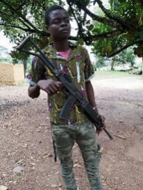
Anti-balaka fighter in Mobaye, 2019 ABMobaye.png
Anti-balaka fighter in Mobaye, 2019

On 8 February 2013 Mobaye was captured by Séléka rebels. [4] In September 2019 Mobaye was reportedly under joint control of Anti-balaka and Union for Peace in the Central African Republic. [5] On 4 May 2021 Mobaye was recaptured by government forces. [6]

Related Research Articles

<span class="mw-page-title-main">Prefectures of the Central African Republic</span>

Since 10 December 2020, The Central African Republic is administratively divided into 20 prefectures and the capital city of Bangui, which is an autonomous commune.

<span class="mw-page-title-main">Bria, Central African Republic</span> Place in Haute-Kotto, Central African Republic

Bria is the capital of Haute-Kotto, one of the 14 prefectures of the Central African Republic. As of the 2003 census the town had a population of 35,204.

<span class="mw-page-title-main">Bambari</span> Place in Ouaka, Central African Republic

Bambari is a town in the Central African Republic, lying on the Ouaka River. It has a population of 41,356 and is the capital of Ouaka prefecture. Bambari is an important market town and home to Bambari Airport, and the Roman Catholic Diocese of Bambari.

<span class="mw-page-title-main">Kaga-Bandoro</span> Place in Nana-Grébizi, Central African Republic

Kaga-Bandoro is a market town and capital of the Nana-Grébizi prefecture of the Central African Republic. It represents the seat of the Roman Catholic Diocese of Kaga–Bandoro. The town has been renamed twice.

<span class="mw-page-title-main">Alindao</span> Place in Basse-Kotto, Central African Republic

Alindao is a town and sub-prefecture located in the Central African Republic prefecture of Basse-Kotto. It lies at the junction of the National Route 2 and 22. Alindao had a population of 14,401 as of the 2003 census; and a calculated 2013 population of 15,213. The town is the seat of the Roman Catholic Diocese of Alindao. It has a small airport, Alindao Airport. A Catholic Mission was established at Alindao during French occupation under French Equatorial Africa.

<span class="mw-page-title-main">Bozoum</span> Place in Ouham-Pendé, Central African Republic

Bozoum is the capital of Ouham-Pendé, one of the 14 prefectures of the Central African Republic.

<span class="mw-page-title-main">Boda, Lobaye</span> Place in Lobaye, Central African Republic

Boda is a town located in the Central African Republic prefecture of Lobaye.

Bouca is a town located in the Central African Republic prefecture of Ouham-Fafa. It is not far east of Bossangoa at the Fafa river.

Ouadda is a town located in the Central African Republic prefecture of Haute-Kotto.

Ippy is a town located in the Central African Republic prefecture of Ouaka, near the geographic center of the country. It is 364 kilometers from the city of Bangui directly. Driving distance, however, is 496 kilometers.

Kembé is a town located in the Central African Republic prefecture of Basse-Kotto. The Kotto Falls double waterfall is nearby.

<span class="mw-page-title-main">Paoua</span> Place in Lim-Pendé, Central African Republic

Paoua is a town located in the Central African Republic prefecture of Lim-Pendé.The town is the birthplace of the former president of the Central African Republic, Ange-Félix Patassé and mathematician, Gaston Nguérékata.

Yalinga is a town and sub-prefecture in the Haute-Kotto prefecture of the central-eastern Central African Republic.

<span class="mw-page-title-main">Mingala</span> Sub-prefecture and town in Basse-Kotto, Central African Republic

Mingala is a sub-prefecture and town in the Basse-Kotto Prefecture of the southern Central African Republic.

<span class="mw-page-title-main">Bakala, Central African Republic</span> Sub-prefecture and town in Ouaka, Central African Republic

Bakala is a sub-prefecture and town in the Ouaka Prefecture of the southern-central Central African Republic. It is located near the geographic center of the country.

Am Dafok, also spelt Am Dafock, is a Sub-Prefecture and town in the Vakaga prefecture of Central African Republic (CAR). The town sits on the CAR side of the border with Sudan; on the Sudanese side of the border lies Um Dafuq in the state of South Darfur.

Satema is a sub-prefecture of Basse-Kotto in the Central African Republic.

Zangba is a sub-prefecture of Basse-Kotto in the Central African Republic.

Ndjoukou is a sub-prefecture of Kémo in the Central African Republic.

<span class="mw-page-title-main">Bienvenue Nguiambi</span> Central African militant

Bienvenue Nguiambi – is an Anti-balaka commander from Yehou village in Basse-Kotto prefecture in the Central African Republic, responsible for multiple crimes against civilians including kidnappings for ransom and murder.

References

  1. Oubangui Medias, Oubangui Medias. "Centrafrique : Décrets portant nomination des Gouverneurs, des Préfets et des Sous-Préfets". oubanguimedias.com. Oubangui Medias. Retrieved 6 June 2024.
  2. "Central African Republic". City Population. Retrieved 7 September 2020.
  3. Clive Alfred Spinager (2012). "20.8 CAR and Chad". African Ecology: Benchmarks and Historical Perspectives. Springer. p. 989.
  4. Situation Report No. 6 (as of 18 February 2013)
  5. Letter dated 6 December 2019 from the Panel of Experts on the Central African Republic extended pursuant to resolution 2454 (2019) addressed to the President of the Security Council , page 26
  6. RCA : la ville de Mobaye, chef-lieu de la Basse-Kotto, a été reprise par les forces alliées ce mardi soir, 4 May 2021

4°19′N21°11′E / 4.317°N 21.183°E / 4.317; 21.183