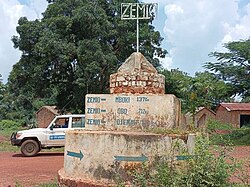
Zemio

Last updated
Zemio
Sub-prefecture and town
A Zemio, au sud-est de la RCA.jpg
Zemio in August 2023
Haut-Mbomou sub-prefectures.png
Sub-prefectures of Haut-Mbomou
Central African Republic location map.svg
Red pog.svg
Zemio
Location in the Central African Republic
Coordinates: 5°2′N25°8′E / 5.033°N 25.133°E / 5.033; 25.133
CountryFlag of the Central African Republic.svg  Central African Republic
Prefecture Haut-Mbomou
Government
  Sub-prefectAroun Bi Ndjobdi [1]
  Mayor Rosalie Nawira [2]
Time zone UTC+1 (WAT)

Zemio is a town and sub-prefecture in the Haut-Mbomou prefecture of the south-eastern Central African Republic. Zemio was the former capital of the Sultanate of Zemio before it was abolished in 1923 by France. [3]

Contents

History

French Congo colonial government sent five prisoners from Annam to Zemio to work for the French garrison in 1896. The workers planted rice, banana, and tobacco and established a settlement near the town. The prisoners stayed in Zemio until 10 April 1904, when they had to move to Brazzaville. [4] In 1924, a missionary named John Buyse established AIM mission station in Zemio. [5]

In the 1970s, Zemio was the center of the illegal ivory trade. [3]

Central African Republic Civil War (2012-present)

In May 2014, Anti-balaka militia from Bahr attacked Zemio. [6] From 18 to 21 November 2014, a sectarian clash between Muslims and Christians ensued in Zemio, resulting in two people dead, two missing, and 15 injured. Thirty-eight houses were burned in Mama 1 neighborhood. [7]

On 28 June 2017 Ugandan forces withdrew from Zemio. Armed Muslims entered town, killing at least 28 civilians. [8] As of January 2021 Zemio remains under control of Union for Peace in the Central African Republic rebel groups. [9]

FACA and Wagner mercenaries from Bangui and Obo arrived in Zemio on 25 May 2024 after more than six years. [10]

Demography

Ethnic Groups

Zemio is a diverse town. It is inhabited by Zande, Banda, Runga, Gula, Peuhl, and Arabs. [11]

Religion

Parish of St. Jean Baptiste Parroquia St. Jean Baptiste (Zemio).JPG
Parish of St. Jean Baptiste

Christians from Catholic and Protestant denominations and Muslims can be found in Zemio. In addition, there is a catholic church, a Protestant church, and a mosque in the town. [12]

Economy

Agriculture is the main source of income for the town residents. Other than that, some town residents engage in fishing, hunting, and honey-gathering activities for their livelihood. [13] As of August 2023, Zemio is considered the most expensive city in Central African Republic. One bag of flour and sugar is priced at 70,000 and 80,000 CFA Francs, respectively. Deplorable road conditions lead to Zemio, causing the journey from Bangui to Zemio to take two months, and the increase in fuel fare are attributed to the skyrocketting price of commodities in the town. [14]

Healthcare

There are two health centers in the town, which are owned by the government and Africa Inland Mission. [15] Currently, the public health center has only one doctor. [16]

Security

From 2018 to 2024 the town's security is only served by the Morocco contingent of MINUSCA. [17] [10]

Transport

The town is served by Zemio Airport.

Related Research Articles

<span class="mw-page-title-main">Obo</span> Place in Haut-Mbomou, Central African Republic

Obo is the capital of Haut-Mbomou, one of the 14 prefectures of the Central African Republic. It is close to the African Pole of Inaccessibility.

<span class="mw-page-title-main">Bouar</span> Place in Nana-Mambéré, Central African Republic

Bouar is a market town in the western Central African Republic, lying on the main road from Bangui (437 km) to the frontier with Cameroon (210 km). The city is the capital of Nana-Mambéré prefecture, has a population of 40,353, while the whole sous-préfecture has a population of 96,595. Bouar lies on a plateau almost 1000m above sea level and is known as the site of Camp Leclerc, a French military base.

<span class="mw-page-title-main">Kabo</span> Town in the Central African Republic

Kabo is a town in the northern Central African Republic, lying north west of Kaga Bandoro. It is a market town and the border post for Chad.

<span class="mw-page-title-main">Djemah</span> Sub-prefecture and town in Haut-Mbomou, Central African Republic

Djemah is a town and sub-prefecture in the Haut-Mbomou Prefecture of the south-eastern Central African Republic. It is the least-populous sub-prefecture in the country. The town is largely neglected by the central government since the country gained independence from France in 1960.

<span class="mw-page-title-main">Markounda</span> Sub-prefecture and town in Ouham, Central African Republic

Markounda, formerly Fort-Brusseaux, is a sub-prefecture and town in the Ouham Prefecture of the north-western Central African Republic. The sub-prefecture borders with Chad.

<span class="mw-page-title-main">Abakar Sabone</span>

Abakar Sabone was the leader of the Movement of Central African Liberators for Justice rebel group during the Central African Republic Bush War.

Nana-Bakassa is a sub-prefecture of Ouham in the Central African Republic.

Moyenne-Sido is a locality in the prefecture of Ouham, in the Central African Republic.

<span class="mw-page-title-main">Mboki</span> Sub-prefecture and town in Haut-Mbomou, Central African Republic

Mboki is a town and sub-prefecture in the Haut-Mbomou prefecture of the south-eastern Central African Republic.

<span class="mw-page-title-main">Tiringoulou</span> Place in Vakaga, Central African Republic

Tiringoulou, also spelled Tirigoulou or Tiroungoulou, is a village in the Vakaga Prefecture in the northern Central African Republic.

<span class="mw-page-title-main">Sikkikede</span> Place in Vakaga, Central African Republic

Sikkikede , also spelled Sikikédé and Sikikede, is a town in Vakaga Prefecture, Central African Republic. It is the largest settlement in Vakaga, with a population of around 20.000 people. CPJP established the headquarter in Sikkikede.

Besson is a village located in Nana-Mambéré Prefecture, Central African Republic. It is the capital of Gaudrot Commune. Peuhl herders from Chad and Cameroon often visit Besson.

Ndim is a village located in Lim-Pendé, Central African Republic.

<span class="mw-page-title-main">Ngakobo</span> Place in Ouaka, Central African Republic

Ngakobo is a town located in Ouaka Prefecture, Central African Republic.

Mbo, also spelled Mboh, is a village situated in Ouham-Fafa Prefecture, Central African Republic.

Bouzou is a village situated in Ouham-Pendé Prefecture, Central African Republic.

Manou is a mining village situated 5 km from Gordil in Vakaga Prefecture, Central African Republic.

<span class="mw-page-title-main">Joseph Bendounga</span> Central African opposition politician

Joseph Bendounga, nicknamed Joe Ben, is a Central African politician. He is known for his eternal opponent of every country's administration since Patasse, which led to him to get arrested several times.

Gazi-Béa, also known as Gazibéa and Gazibeya, is a village situated in Lobaye Prefecture, Central African Republic.

<span class="mw-page-title-main">Lycée Barthélémy Boganda de Bangui</span> Public school in Central African Republic

Lycée Barthelemy Boganda is a public high school situated in Bangui. The school is named after Barthelemy Boganda.

References

  1. Ndeke Luka, Ndeke Luka. "Zémio : "Jusque-là, on vit sans les forces de sécurité intérieure"". radiondekeluka.org. Radio Ndeke Luka. Retrieved 24 August 2023.
  2. "Centrafrique : colère et stupéfaction des habitants de Zémio contre les taxes illégales instaurées par le maire de la ville". 19 July 2022.
  3. 1 2 Rius, Juan Fandos; Bradshaw, Richard (2016). Historical Dictionary of the Central African Republic. Maryland: Rowman & Littlefield. p. 659. ISBN   9780810879928.
  4. Pearson, Mark; Fandos-Rius, Juan (2018). Le Cimetière Colonial (PDF) (Report). p. 12. Retrieved 12 February 2023.
  5. Rius, Juan Fandos; Bradshaw, Richard (2016). Historical Dictionary of the Central African Republic. Maryland: Rowman & Littlefield. p. iv. ISBN   9780810879928.
  6. Concordis (October 2021). Rapport du projet RELSUDE : Analyse des conflits à Zemio (PDF) (Report). p. 10. Retrieved 1 June 2023.
  7. ACTED (31 December 2014). Rapport d’Evaluation Multisectorielle - RRM: Barh, Bogou, Aliwali Sous-préfecture Zémio - Décembre 2014 (PDF) (Report). p. 3. Retrieved 1 June 2023.
  8. "Central African Republic: Civilians Targeted as Violence Surges". 27 October 2017.
  9. RCA : les rebelles du CPC occupent Zémio et sont en route pour Obo, 23 January 2021
  10. 1 2 Ndeke Luka, Ndeke Luka. "Centrafrique : les Faca font leur retour à Zemio après près d'une décennie d'absence". radiondekeluka.org. Radio Ndeke Luka. Retrieved 28 May 2024.
  11. Concordis (October 2021). Rapport du projet RELSUDE : Analyse des conflits à Zemio (PDF) (Report). p. 8. Retrieved 1 June 2023.
  12. Concordis (October 2021). Rapport du projet RELSUDE : Analyse des conflits à Zemio (PDF) (Report). p. 23. Retrieved 1 June 2023.
  13. Concordis (October 2021). Rapport du projet RELSUDE : Analyse des conflits à Zemio (PDF) (Report). p. 17. Retrieved 1 June 2023.
  14. Ndeke Luka, Ndeke Luka. "Centrafrique : Zemio, ville la plus chère de la RCA ?". radiondekeluka.org. Radio Ndeke Luka. Retrieved 23 August 2023.
  15. World Health Organization (March 2017). Enquête rapide sur l'estimation des besoins de santé des populations affectées par la crise en République Centrafricaine en 2016 (PDF) (Report). p. UU. Retrieved 12 September 2023.
  16. Ndeke Luka, Ndeke Luka. "Centrafrique : la ville de Zemio en passe d'être décimée par le VIH/Sida ?". radiondekeluka.org. Radio Ndeke Luka. Retrieved 12 September 2023.
  17. Ndeke Luka, Ndeke Luka. "Centrafrique : l'absence des FDS plonge davantage la ville de Zémio dans une crise sécuritaire profonde". radiondekeluka.org. Radio Ndeke Luka. Retrieved 25 August 2023.