Bahr, Central African Republic

Last updated
Bahr
Central African Republic location map.svg
Red pog.svg
Bahr
Location in Central African Republic
Coordinates: 5°7′11″N24°50′25″E / 5.11972°N 24.84028°E / 5.11972; 24.84028
Country Central African Republic
Prefecture Haut-Mbomou
Sub-prefecture Zemio
CommuneZemio
Population
 (2020)
  Total382 [1]

Bahr, also spelled Barh, is a village located in Haut-Mbomou Prefecture, Central African Republic.

Contents

History

UNICEF built a borehole equipped with a manual pump in 2002 to provide clean drinking water access for Bahr residents. Unfortunately, the pump was broken at the end of 2002. [2]

Revenging the death of a Muslim merchant death in Sélim by an unknown person, the victim's family armed with weapons entered Bahr on 15 November 2014 and clashed with the locals. No casualties were reported and the victim families retreated from the village. An armed group attacked Bahr on 1 December 2014. They burned 18 houses and two straw huts. Three people died and two were injured. [3]

On 4 September 2016 at 4 am, an armed group raided Bahr. The villagers fled to the bush and the militias looted houses and kiosks. The local residents returned to the village in the evening. [4]

Education

Bahr has one school. In 2016, the militia destroyed the school materials. [5]

Healthcare

The village has one health post. [6]

Related Research Articles

Krakoma is a village in the Bamingui-Bangoran Prefecture in the northern Central African Republic.

Pata, also known as Kpata, is a village in the Bamingui-Bangoran prefecture in the northern Central African Republic.

<span class="mw-page-title-main">Zemio</span> Sub-prefecture and town in Haut-Mbomou, Central African Republic

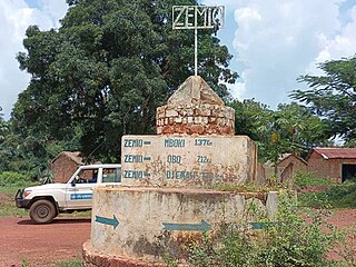
Zemio is a town and sub-prefecture in the Haut-Mbomou prefecture of the south-eastern Central African Republic. Zemio was the former capital of the Sultanate of Zemio before it was abolished in 1923 by France.

<span class="mw-page-title-main">Sikkikede</span> Place in Vakaga, Central African Republic

Sikkikede , also spelled Sikikédé and Sikikede, is a town in Vakaga Prefecture, Central African Republic. It is the largest settlement in Vakaga, with a population of around 20.000 people. CPJP established the headquarter in Sikkikede.

Derbissaka, also spelled Derbisaka, is a village located in Mbomou, Central African Republic.

Dembia is a village located near the border of Mbomou and Haut-Mbomou Prefecture.

Agoumar is a village located in Mbomou. It is situated near Rafai town in Central African Republic.

Guinikoumba, also spelled Guénékoumba, is a village located in Haut-Mbomou Prefecture, Central African Republic.

Tabane is a village located in Haut-Mbomou Prefecture, Central African Republic.

Tambourah, also spelled Tamboura, is a village located in Haut-Mbomou Prefecture, Central African Republic.

Bémal is a village located in Lim-Pendé Prefecture, Central African Republic. Until December 2020, Bémal was part of Ouham-Pende.

Sélim is a village situated in Mbomou Prefecture, Central African Republic.

Bogou is a village situated in Haut-Mbomou Prefecture, Central African Republic.

Dilapoko is a village located in Mambéré-Kadéï Prefecture, Central African Republic.

Aïfa is a village located near Sikkikede in Vakaga Prefecture, Central African Republic.

Pougol is a town situated in Lim-Pendé, Central African Republic. Until 2020, the town was part of Ouham-Pendé.

Aliwali is a village located 12 km from Zemio in Haut-Mbomou Prefecture, Central African Republic.

Digui is a village located in Ouaka Prefecture, Central African Republic. The village is strategic since it is situated at the crossroads to Bambari, Alindao, and Ngakobo.

Batobadja is a village situated in Ouaka Prefecture, Central African Republic.

Guibéré is a village situated in Haut-Mbomou Prefecture, Central African Republic.

References

  1. ACTED (28 November 2020). RCA : Evaluation Multisectorielle à Guinikoumba et Bahr (Préfecture du Haut-Mbomou) (ACTED/25.11.2020) (PDF) (Report). p. 1. Retrieved 12 May 2023.
  2. ACTED Evaluation Multisectorielle 2016, p. 2.
  3. ACTED (31 December 2014). Rapport d’Evaluation Multisectorielle - RRM: Barh, Bogou, Aliwali Sous-préfecture Zémio - Décembre 2014 (PDF) (Report). p. 3. Retrieved 12 May 2023.
  4. ACTED (10 April 2016). EVALUATION MULTISECTORIELLE : RAPPORT PRELIMINAIRE Village de Bahr, Sous-préfecture Zemio, préfecture du Haut Mbomou (PDF) (Report). p. 1. Retrieved 12 May 2023.
  5. ACTED Evaluation Multisectorielle 2016, p. 5.
  6. World Health Organization (March 2017). Enquête rapide sur l'estimation des besoins de santé des populations affectées par la crise en République Centrafricaine en 2016 (PDF) (Report). p. UU. Retrieved 12 May 2023.

Bibliography