
Kyūshū is the third-largest island of Japan's four main islands and the most southerly of the four largest islands. In the past, it has been known as Kyūkoku, Chinzei and Tsukushi-no-shima. The historical regional name Saikaidō referred to Kyushu and its surrounding islands. Kyushu has a land area of 36,782 square kilometres (14,202 sq mi) and a population of 14,311,224 in 2018.

Hokkaido is the second-largest island of Japan and comprises the largest and northernmost prefecture, making up its own region. The Tsugaru Strait separates Hokkaidō from Honshu; the two islands are connected by the undersea railway Seikan Tunnel.

Honshu, historically called Akitsushima, is the largest and most populous island of Japan. It is located south of Hokkaidō across the Tsugaru Strait, north of Shikoku across the Inland Sea, and northeast of Kyūshū across the Kanmon Straits. The island separates the Sea of Japan, which lies to its north and west, from the North Pacific Ocean to the south and east. It is the seventh-largest island in the world, and the second-most populous after the Indonesian island of Java.

Kanagawa Prefecture is a prefecture of Japan located in the Kantō region of Honshu. Kanagawa Prefecture is the second-most populous prefecture of Japan at 9,221,129 and third-densest at 3,800 inhabitants per square kilometre (9,800/sq mi). Its geographic area of 2,415 km2 (932 sq mi) makes it fifth-smallest. Kanagawa Prefecture borders Tokyo to the north, Yamanashi Prefecture to the northwest and Shizuoka Prefecture to the west.

In France, a prefecture may be:
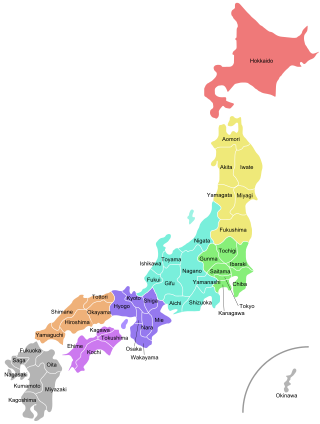
Japan is divided into 47 prefectures, which rank immediately below the national government and form the country's first level of jurisdiction and administrative division. They include 43 prefectures proper, two urban prefectures, one regional prefecture and one metropolis. In 1868, the Meiji Fuhanken sanchisei administration created the first prefectures to replace the urban and rural administrators in the parts of the country previously controlled directly by the shogunate and a few territories of rebels/shogunate loyalists who had not submitted to the new government such as Aizu/Wakamatsu. In 1871, all remaining feudal domains (han) were also transformed into prefectures, so that prefectures subdivided the whole country. In several waves of territorial consolidation, today's 47 prefectures were formed by the turn of the century. In many instances, these are contiguous with the ancient ritsuryō provinces of Japan.
The administrative divisions of China have consisted of several levels since ancient times, due to China's large population and geographical area. The constitution of China provides for three levels of government. However in practice, there are five levels of local government; the provincial, prefecture, county, township, and village.
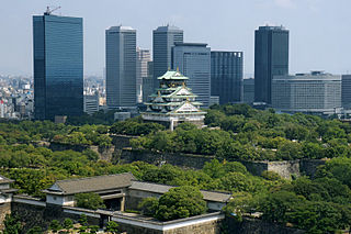
Osaka Prefecture is a prefecture of Japan located in the Kansai region of Honshu. Osaka Prefecture has a population of 8,778,035 and has a geographic area of 1,905 square kilometres (736 sq mi). Osaka Prefecture borders Hyōgo Prefecture to the northwest, Kyoto Prefecture to the north, Nara Prefecture to the southeast, and Wakayama Prefecture to the south.

Kyoto Prefecture is a prefecture of Japan located in the Kansai region of Honshu. Kyoto Prefecture has a population of 2,561,358 and has a geographic area of 4,612 square kilometres (1,781 sq mi). Kyoto Prefecture borders Fukui Prefecture to the northeast, Shiga Prefecture to the east, Mie Prefecture to the southeast, Nara Prefecture and Osaka Prefecture to the south, and Hyōgo Prefecture to the west.
Nagano Prefecture is a landlocked prefecture of Japan located in the Chūbu region of Honshū. Nagano Prefecture has a population of 2,007,682 and has a geographic area of 13,561.56 square kilometres (5,236.15 sq mi). Nagano Prefecture borders Niigata Prefecture to the north, Gunma Prefecture to the northeast, Saitama Prefecture to the east, Yamanashi Prefecture to the southeast, Shizuoka Prefecture and Aichi Prefecture to the south, and Gifu Prefecture and Toyama Prefecture to the west.
Chiba Prefecture is a prefecture of Japan located in the Kantō region of Honshu. Chiba Prefecture has a population of 6,278,060 and has a geographic area of 5,157 km2 (1,991 sq mi). Chiba Prefecture borders Ibaraki Prefecture to the north, Saitama Prefecture to the northwest, and Tokyo to the west.

Hiroshima Prefecture is a prefecture of Japan located in the Chūgoku region of Honshu. Hiroshima Prefecture has a population of 2,811,410 and has a geographic area of 8,479 km². Hiroshima Prefecture borders Okayama Prefecture to the east, Tottori Prefecture to the northeast, Shimane Prefecture to the north, and Yamaguchi Prefecture to the southwest.

Saitama Prefecture is a landlocked prefecture of Japan located in the Kantō region of Honshu. Saitama Prefecture has a population of 7,338,536 and has a geographic area of 3,797 km2. Saitama Prefecture borders Tochigi Prefecture and Gunma Prefecture to the north, Nagano Prefecture to the west, Yamanashi Prefecture to the southwest, Tokyo to the south, Chiba Prefecture to the southeast, and Ibaraki Prefecture to the northeast.

Shizuoka Prefecture is a prefecture of Japan located in the Chūbu region of Honshu. As of September 2023, Shizuoka Prefecture has a population of 3,555,818 and has a geographic area of 7,777.42 km2 (3,002.88 sq mi). Shizuoka Prefecture borders Kanagawa Prefecture to the east, Yamanashi Prefecture to the northeast, Nagano Prefecture to the north, and Aichi Prefecture to the west.

The Kantō region is a geographical region of Honshu, the largest island of Japan. In a common definition, the region includes the Greater Tokyo Area and encompasses seven prefectures: Gunma, Tochigi, Ibaraki, Saitama, Tokyo, Chiba, and Kanagawa. Slightly more than 45 percent of the land area within its boundaries is the Kantō Plain. The rest consists of the hills and mountains that form land borders with other regions of Japan.

Hyōgo Prefecture is a prefecture of Japan located in the Kansai region of Honshu. Hyōgo Prefecture has a population of 5,469,762 and a geographic area of 8,400 square kilometres. Hyōgo Prefecture borders Kyoto Prefecture to the east, Osaka Prefecture to the southeast, and Okayama and Tottori prefectures to the west.

A prefecture-level city or prefectural city is an administrative division of the People's Republic of China (PRC), ranking below a province and above a county in China's administrative structure.

Aichi Prefecture is a prefecture of Japan located in the Chūbu region of Honshū. Aichi Prefecture has a population of 7,552,873 and a geographic area of 5,172.92 square kilometres (1,997.28 sq mi) with a population density of 1,460 inhabitants per square kilometre (3,800/sq mi). Aichi Prefecture borders Mie Prefecture to the west, Gifu Prefecture and Nagano Prefecture to the north, and Shizuoka Prefecture to the east. Nagoya is the capital and largest city of the prefecture.
Greek vehicle registration plates are composed of three letters and four digits per plate printed in black on a white background. The letters represent the district (prefecture) that issues the plates while the numbers range from 1000 to 9999. As of 2004 a blue strip was added on the left showing the country code of Greece (GR) in white text and the Flag of Europe in yellow. Similar plates but of square size with numbers ranging from 1 to 999 are issued for motorcycles which exceed 50 cc in engine size.

Miyagi Prefecture is a prefecture of Japan located in the Tōhoku region of Honshu. Miyagi Prefecture has a population of 2,265,724 and has a geographic area of 7,282 km2 (2,812 sq mi). Miyagi Prefecture borders Iwate Prefecture to the north, Akita Prefecture to the northwest, Yamagata Prefecture to the west, and Fukushima Prefecture to the south.


