Pata, also known as Kpata, is a village in the Bamingui-Bangoran prefecture in the northern Central African Republic.
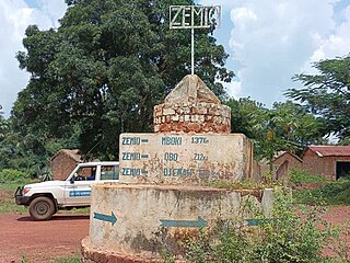
Zemio is a town and sub-prefecture in the Haut-Mbomou prefecture of the south-eastern Central African Republic. Zemio was the former capital of the Sultanate of Zemio before it was abolished in 1923 by France.
Sam Ouandja is a town located in the Central African Republic prefecture of Haute-Kotto near the border with Sudan. It has historically served as important arms trafficking hub for armed groups in Central African Republic. Artisanal diamond mining is also active in the commune.

Mboki is a town and sub-prefecture in the Haut-Mbomou prefecture of the south-eastern Central African Republic.

Tiringoulou, also spelled Tirigoulou or Tiroungoulou, is a village in the Vakaga Prefecture in the northern Central African Republic.
Boromata is a village in the Vakaga Prefecture in the northern Central African Republic.

Sikkikede , also spelled Sikikédé and Sikikede, is a town in Vakaga Prefecture, Central African Republic. It is the largest settlement in Vakaga, with a population of around 20.000 people. CPJP established the headquarter in Sikkikede.
Boungou is a village located in Haute-Kotto, Central African Republic. There is diamond mining in the village located on the bank of the Boungou River.
Agoumar is a village located in Mbomou. It is situated near Rafai town in Central African Republic.
Besson is a village located in Nana-Mambéré Prefecture, Central African Republic. It is the capital of Gaudrot Commune. Peuhl herders from Chad and Cameroon often visit Besson.
Bémal is a village located in Lim-Pendé Prefecture, Central African Republic. Until December 2020, Bémal was part of Ouham-Pende.
Bohong is a town located in Ouham-Pendé Prefecture, Central African Republic.
Maloum is a village located in Ouaka Prefecture, Central African Republic.
Bangao is a village situated in Ouaka Prefecture, Central African Republic.
Mann, also spelled Man, is a village situated in Lim-Pendé Prefecture, Central African Republic.
Nzakoundou is a village in the prefecture of Lim-Pendé in the Central African Republic.
Pavica, also spelled Pavika, is a village situated in Basse-Kotto Prefecture, Central African Republic.
Bouzou is a village situated in Ouham-Pendé Prefecture, Central African Republic.
Kpokpo is a village situated in Haute-Kotto Prefecture, Central African Republic.

Cantonnier is a border town situated near Cameroon–Central African Republic border in Nana-Mambéré Prefecture.
