
Burkina Faso is a landlocked Sahel country that shares borders with six nations. It lies between the Sahara desert and the Gulf of Guinea, south of the loop of the Niger River, mostly between latitudes 9° and 15°N, and longitudes 6°W and 3°E. The land is green in the south, with forests and fruit trees, and semi-arid in the north. Most of central Burkina Faso lies on a savanna plateau, 198–305 metres (650–1,001 ft) above sea level, with fields, brush, and scattered trees. Burkina Faso's game preserves – the most important of which are Arly, Nazinga, and W National Park—contain lions, elephants, hippopotamus, monkeys, common warthogs, and antelopes. Previously the endangered painted hunting dog, Lycaon pictus occurred in Burkina Faso, but, although the last sightings were made in Arli National Park, the species is considered extirpated from Burkina Faso.
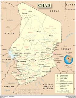
Chad is one of the 48 landlocked countries in the world and is located in North Central Africa, measuring 1,284,000 square kilometers (495,755 sq mi), nearly twice the size of France and slightly more than three times the size of California. Most of its ethnically and linguistically diverse population lives in the south, with densities ranging from 54 persons per square kilometer in the Logone River basin to 0.1 persons in the northern B.E.T. (Borkou-Ennedi-Tibesti) desert region, which itself is larger than France. The capital city of N'Djaména, situated at the confluence of the Chari and Logone Rivers, is cosmopolitan in nature, with a current population in excess of 700,000 people.

The Central African Republic is a landlocked nation within the interior of the African continent. It is bordered by Cameroon, Chad, Sudan, South Sudan, the Democratic Republic of the Congo and the Republic of the Congo. Much of the country consists of flat, or rolling plateau savanna, about 1,640 feet (500 m) above sea level. In the northeast are the Fertit Hills, and there are scattered hills in the southwestern part of the country. To the northwest is the Karre Mountains, a granite plateau with an altitude of 3,750 feet (1,143 m).

The Dominican Republic is a country in the West Indies that occupies the eastern five-eighths of Hispaniola. It has an area of 48,670 km2, including offshore islands. The land border shared with Haiti, which occupies the western three-eighths of the island, is 376 km long. The maximum length, east to west, is 390 km from Punta de Agua to Las Lajas, on the border with Haiti. The maximum width, north to south, is 265 km from Cape Isabela to Cape Beata. The capital, Santo Domingo, is located on the south coast.

The Republic of Haiti comprises the western three-eighths of the island of Hispaniola, west of the Dominican Republic. Haiti is positioned east of the neighboring island of Cuba, between the Caribbean Sea and the North Atlantic Ocean. Haiti's geographic coordinates are at a longitude of 72° 25′ west and a latitude of 19° 00′ north.

Sudan is located in Northeast Africa. It is bordered by Egypt to the north, the Red Sea to the northeast, Eritrea and Ethiopia to the east, South Sudan to the south, the Central African Republic to the southwest, Chad to the west and Libya to the northwest. Sudan is the third largest country in Africa, after Algeria and the Democratic Republic of the Congo. It had been the largest country on the continent until the 2011 independence of South Sudan.

The Limpopo River rises in South Africa, and flows generally eastwards through Mozambique to the Indian Ocean. The term Limpopo is derived from Rivombo (Livombo/Lebombo), a group of Tsonga settlers led by Hosi Rivombo who settled in the mountainous vicinity and named the area after their leader. The river is approximately 1,750 kilometres (1,087 mi) long, with a drainage basin 415,000 square kilometres (160,200 sq mi) in size. The mean discharge measured over a year is 170 m3/s at its mouth. The Limpopo is the second largest river in Africa that drains to the Indian Ocean, after the Zambezi River.

Madagascar is a large island in the Indian Ocean off the eastern coast of southern Africa, east of Mozambique. It has a total area of 587,040 square kilometres (226,660 sq mi) with 581,540 square kilometres (224,530 sq mi) of land and 5,500 square kilometres (2,100 sq mi) of water. Madagascar is the fourth largest island and the 2nd largest island country in the world. The highest point is Maromokotro, in the Tsaratanana Massif region in the north of the island, at 2,876 metres (9,436 ft). The capital Antananarivo is in the Central Highlands near the centre of the island. It has the 25th largest Exclusive Economic Zone of 1,225,259 km2 (473,075 sq mi). Madagascar is 400 kilometres east of mainland Africa.

The Paraná River is a river in south Central South America, running through Brazil, Paraguay, and Argentina for some 4,880 kilometres (3,030 mi). It is second in length only to the Amazon River among South American rivers. The name Paraná is an abbreviation of the phrase "para rehe onáva", which comes from the Tupi language and means "like the sea". It merges first with the Paraguay River and then farther downstream with the Uruguay River to form the Río de la Plata and empties into the Atlantic Ocean.

Europe is traditionally defined as one of seven continents. Physiographically, it is the northwestern peninsula of the larger landmass known as Eurasia ; Asia occupies the eastern bulk of this continuous landmass and all share a common continental shelf. Europe's eastern frontier is delineated by the Ural Mountains in Russia, which is the largest country by land area in the continent. The southeast boundary with Asia is not universally defined, but the modern definition is generally the Ural River or, less commonly, the Emba River. The boundary continues to the Caspian Sea, the crest of the Caucasus Mountains, and on to the Black Sea. The Bosporus, the Sea of Marmara, and the Dardanelles conclude the Asian boundary. The Mediterranean Sea to the south separates Europe from Africa. The western boundary is the Atlantic Ocean. Iceland, though on the Mid-Atlantic Ridge and nearer to Greenland than Mainland Europe, is generally included in Europe for cultural reasons and because it is over twice as close to mainland Europe as mainland North America. There is ongoing debate on where the geographical centre of Europe falls.

Monte Rosa is a mountain massif in the eastern part of the Pennine Alps. It is between Italy's and Switzerland's (Valais). Monte Rosa is the second highest mountain in the Alps and western Europe, after Mont Blanc.
The Logon or Logone River is a major tributary of the Chari River. The Logone's sources are located in the western Central African Republic, northern Cameroon, and southern Chad. It has two major tributaries: the Pendé River in the prefecture Ouham-Pendé in the Central African Republic and the Mbéré River at the east of Cameroon. Many swamps and wetlands surround the river.

The Radika is a river in southern Kosovo and western North Macedonia, a 70 km (43 mi)-long right tributary to the Black Drin river.
The Lillooet Icecap, also called the Lillooet Icefield or the Lillooet Crown, is a large icefield in the Pacific Ranges of the Coast Mountains in southwestern British Columbia, Canada. It is about 90 km (56 mi) northwest of the towns of Pemberton and Whistler, and about 175 km (109 mi) north of Vancouver, British Columbia. The Lillooet Icecap is one of the largest of several large icefields in the Pacific Ranges which are the largest temperate-latitude glacial fields in the world. At its maximum extent including its glacial tongues it measures 30 km (19 mi) east to west and 20 km (12 mi) north to south; its central icefield area is approximately 15 km (9 mi) in diameter.

Ouanda Djallé is a sub-prefecture and town in the prefecture of Vakaga in the Central African Republic. It is located 130 km south of Birao. By population it is one of the smallest sub-prefectures in the country.

The Bahr el Ghazal is a river in South Sudan. The name translates as "sea of gazelles" from Arabic. The South Sudanese region of Bahr el Ghazal takes its name from the river.

Angola is located on the western Atlantic Coast of Central Africa between Namibia and the Republic of the Congo. It also is bordered by the Democratic Republic of the Congo and Zambia to the east. The country consists of a sparsely watered and somewhat sterile coastal plain extending inland for a distance varying from 50 to 160 km. Slightly inland and parallel to the coast is a belt of hills and mountains and behind those a large plateau. The total land size is 1,246,700 km2 (481,400 sq mi). It has an Exclusive Economic Zone of 518,433 km2 (200,168 sq mi).
The Lake Chad replenishment project is a proposed major water diversion scheme to divert water from the Congo River basin to Lake Chad to prevent it drying up. Various versions have been proposed. Most would involve damming some of the right tributaries of the Congo River and channeling some of the water to Lake Chad via a canal to the Chari River basin.

Engilchek Glacier is a glacier in the Central Tian Shan Mountains of Issyk-Kul Region, northeastern Kyrgyzstan. Its snout is 50 km east of the village of Engilchek. The South Engilchek Glacier ranks as the sixth longest non-polar glacier in the world and is the largest and fastest moving glacier in Kyrgyzstan. The main glacier has two arms, the North and South Engilchek Glaciers. The latter is longer and provides an overall length of 60.5 kilometres (38 mi). with an area of 17.2 square kilometres (7 sq mi) and an ice thickness of roughly 150–200 m in the bottom parts. The glacier stems from the Chinese-Kazakh-Kyrgyz massif of Khan Tengri and Pik Pobedy and the upper part of the glacier falls in all three countries. Meltwater from the glacier feeds the Engilchek River, a tributary of the Saryjaz, which crosses the Chinese border into the Tarim Basin. Water from this glacier also feeds the seasonal glacial Lake Merzbacher which causes frequent glacial lake outburst floods in the Engilchek River valley.

The Congo-Nile Divide is the continental divide that separates the drainage basins of the Nile and Congo rivers. It is about 2,000 kilometres (1,200 mi) long.


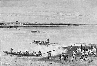
 Steamboat on the Kotto.
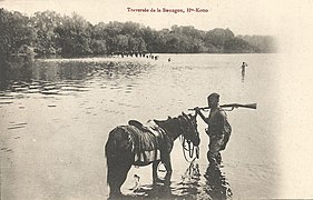 Crossing of the Boungou, a right tributary.
