Royal Proclamation of 1763

Last updated

The Royal Proclamation of 1763, Library and Archives Canada Royal Proclamation of 1763.jpg
The Royal Proclamation of 1763, Library and Archives Canada
A portion of eastern North America; the 1763 "proclamation line" is the border between the red and the pink areas Map of territorial growth 1775.svg
A portion of eastern North America; the 1763 "proclamation line" is the border between the red and the pink areas

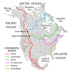
The Royal Proclamation of 1763 was issued by King George III on 7 October 1763. It followed the Treaty of Paris (1763), which formally ended the Seven Years' War and transferred French territory in North America to Great Britain. [1] The Proclamation forbade all settlements west of a line drawn along the Appalachian Mountains, which was delineated as an Indian Reserve. [2] Exclusion from the vast region of Trans-Appalachia created discontent between Britain and colonial land speculators and potential settlers. The proclamation and access to western lands was one of the first significant areas of dispute between Britain and the colonies and would become a contributing factor leading to the American Revolution. [3] The 1763 proclamation line is more or less similar to the Eastern Continental Divide, extending from Georgia in the south to the divide's northern terminus near the middle of the northern border of Pennsylvania, where it intersects the northeasterly St. Lawrence Divide, and extends further through New England.

Contents

The Royal Proclamation continues to be of legal importance to First Nations in Canada, being the first legal recognition of aboriginal title, rights and freedoms, and is recognized in the Constitution Act, 1982, in part as a result of direct action by indigenous peoples of Canada, known as the Constitution Express movement of 1981–1982. [4]

Background: Treaty of Paris

The Seven Years' War and its North American theater, the French and Indian War, ended with the 1763 Treaty of Paris. Under the treaty, all French colonial territory west of the Mississippi River was ceded to Spain, while all French colonial territory east of the Mississippi River and south of Rupert's Land (save Saint Pierre and Miquelon, which France kept) was ceded to Great Britain. Both Spain and Britain received some French islands in the Caribbean, while France kept Haiti and Guadeloupe. [5] [6]

Provisions

New colonies

The Eastern watershed boundary in the southern areas (orange line), and the St. Lawrence watershed boundary in the northern areas (magenta line) of this map more or less defined the Royal Proclamation's western boundaries NorthAmerica-WaterDivides.png
The Eastern watershed boundary in the southern areas (orange line), and the St. Lawrence watershed boundary in the northern areas (magenta line) of this map more or less defined the Royal Proclamation's western boundaries

The Proclamation of 1763 dealt with the management of former French territories in North America that Britain acquired following its victory over France in the French and Indian War, as well as regulating colonial settlers' expansion. It established new governments for several areas: the province of Quebec, the new colonies of West Florida and East Florida, [7] and a group of Caribbean islands, Grenada, Tobago, Saint Vincent, and Dominica, collectively referred to as the British Ceded Islands. [8]

Proclamation line

New borders drawn by the Royal Proclamation of 1763 NorthAmerica1762-83.png
New borders drawn by the Royal Proclamation of 1763

At the outset, the Royal Proclamation of 1763 defined the jurisdictional limits of the British territories of North America, limiting British colonial expansion on the continent. What remained of the Royal Province of New France east of the Great Lakes and the Ottawa River, and south of Rupert's Land, was reorganised under the name "Quebec." The territory northeast of the St. John River on the Labrador coast was reassigned to the Newfoundland Colony. [9] The lands west of Quebec and west of a line running along the crest of the Allegheny Mountains became (British) Indian Territory, barred to settlement from colonies east of the line. [10]

The proclamation line was not intended to be a permanent boundary between the colonists and Native American lands, but rather a temporary boundary that could be extended further west in an orderly, lawful manner. [11] [12] It was also not designed as an uncrossable boundary; people could cross the line, but not settle past it. [13] Its contour was defined by the headwaters that formed the watershed along the Appalachians. All land with rivers that flowed into the Atlantic was designated for the colonial entities, while all the land with rivers that flowed into the Mississippi was reserved for the Native American populations. The proclamation outlawed the private purchase of Native American land, which had often created problems in the past. Instead, all future land purchases were to be made by Crown officials "at some public Meeting or Assembly of the said Indians". British colonials were forbidden to settle on native lands, and colonial officials were forbidden to grant ground or lands without royal approval. Organized land companies asked for land grants, but were denied by King George III. [14]

The Boundary Line Map of 1768 moved the boundary west 1768 Boundary Line Map Treaty of Ft Stanwix.jpg
The Boundary Line Map of 1768 moved the boundary west

British colonists and land speculators objected to the proclamation boundary since the British government had already assigned land grants to them. Including the wealthy owners of the Ohio company who protested the line to the governor of Virginia, as they had plans for settling the land to grow business. [15] Many settlements already existed beyond the proclamation line, [16] some of which had been temporarily evacuated during Pontiac's War, and there were many already granted land claims yet to be settled. For example, George Washington and his Virginia soldiers had been granted lands past the boundary. Prominent American colonials joined with the land speculators in Britain to lobby the government to move the line further west. [3] [17]

The colonists' demands were met and the boundary line was adjusted in a series of treaties with the Native Americans. [18] The first two of these treaties were completed in 1768; the Treaty of Fort Stanwix adjusted the border with the Iroquois Confederacy in the Ohio Country and the Treaty of Hard Labour adjusted the border with the Cherokee in the Carolinas. [19] [20] The Treaty of Hard Labour was followed by the Treaty of Lochaber in 1770, adjusting the border between Virginia and the Cherokee. [21] These agreements opened much of what is now Kentucky and West Virginia to British settlement. [22] The land granted by the Virginian and North Carolinian government heavily favored the land companies, seeing as they had more wealthy backers than the poorer settlers who wanted to settle west in hopes of gaining a fortune. [23]

Response from colonists

Many colonists disregarded the proclamation line and settled west, which created tension between them and the Native Americans. [24] Pontiac's Rebellion (1763–1766) was a war involving Native American tribes, primarily from the Great Lakes region, the Illinois Country and the Ohio Country, who were dissatisfied with British postwar policies in the Great Lakes region after the end of the Seven Years' War. They were able to take over a large number of the forts which commanded the waterways involved in trade within the region and export to Great Britain. [25] The proclamation line had been conceived before the onset of Pontiac's Rebellion, but the outbreak of this conflict hastened the process of making it law. [16]

Legacy

Indigenous peoples

The Royal Proclamation continued to govern the cession of Indigenous land in British North America, especially Upper Canada and Rupert's Land. Upper Canada created a platform for treaty making based on the Royal Proclamation. After loyalists moved into land after Britain's defeat in the American Revolution, the first impetus was created out of necessity. [26]

According to historian Colin Calloway, "scholars disagree on whether the proclamation recognized or undermined tribal sovereignty". [27]

Some see the Royal Proclamation of 1763 as a "fundamental document" for First Nations land claims and self-government. [28] It is "the first legal recognition by the British Crown of Aboriginal rights" [29] and imposes a fiduciary duty of care on the Crown. The intent and promises made to the native in the Proclamation have been argued to be of a temporary nature, only meant to appease the Native peoples who were becoming increasingly resentful of "settler encroachments on their lands" [30] and were capable of becoming a serious threat to British colonial settlement. [31] [32] Advice given by a Sir William Johnson, superintendent of Indian Affairs in North America, to the Board of Trade on August 30, 1764, expressed that:

The Indians all know we cannot be a Match for them in the midst of an extensive woody Country ... from whence I infer that if we are determined to possess Our Posts, Trade & ca securely, it cannot be done for a Century by any other means than that of purchasing the favour of the numerous Indian inhabitants. [33]

Anishinaabe jurist John Borrows has written that "the Proclamation illustrates the British government's attempt to exercise sovereignty over First Nations while simultaneously trying to convince First Nations that they would remain separate from European settlers and have their jurisdiction preserved." [34] Borrows further writes that the Royal Proclamation along with the subsequent Treaty of Niagara, provide for an argument that "discredits the claims of the Crown to exercise sovereignty over First Nations" [35] and affirms Aboriginal "powers of self-determination in, among other things, allocating lands". [36]

Johnson v. McIntosh

The functional content of the proclamation was reintroduced into American law by the decision of the U.S. Supreme Court in Johnson v. McIntosh (1823).[ citation needed ]

250th anniversary celebrations

In October 2013, the 250th anniversary of the Royal Proclamation was celebrated in Ottawa with a meeting of Indigenous leaders and Governor-General David Johnston. [37] The Aboriginal movement Idle No More held birthday parties for the document at various locations across Canada. [38]

United States

USA Proclamation of 1763 Silver Medal: Franklin Mint Issue 1970 USA Proclamation of 1763 Silver Medal 1970.jpg
USA Proclamation of 1763 Silver Medal: Franklin Mint Issue 1970

The influence of the Royal Proclamation of 1763 on the coming of the American Revolution has been variously interpreted. Many historians argue that the proclamation ceased to be a major source of tension after 1768 since the aforementioned later treaties opened up extensive lands for settlement. Others have argued that colonial resentment of the proclamation contributed to the growing divide between the colonies and the mother country. Some historians argue that even though the boundary was pushed west in subsequent treaties, the British government refused to permit new colonial settlements for fear of instigating a war with Native Americans, which angered colonial land speculators. [39] Others argue that the Royal Proclamation imposed a fiduciary duty of care on the Crown. [40]

George Washington was given 20,000 acres (81 km2) of land in the Ohio region for his services in the French and Indian War. In 1770, Washington took the lead in securing the rights of him and his old soldiers in the French War, advancing money to pay expenses on behalf of the common cause and using his influence in the proper quarters. In August 1770, it was decided that Washington should personally make a trip to the western region, where he located and surveyed tracts for himself and military comrades. After some dispute, he was eventually granted letters patent for tracts of land there. The lands involved were open to Virginians under terms of the Treaty of Lochaber of 1770, except for the lands located two miles (3.2 km) south of Fort Pitt, now known as Pittsburgh. [41]

In the United States, the Royal Proclamation of 1763 ended with the American Revolutionary War because Great Britain ceded the land in question to the United States in the Treaty of Paris (1783). Afterward, the U.S. government also faced difficulties in preventing frontier violence and eventually adopted policies similar to those of the Royal Proclamation. The first in a series of Indian Intercourse Acts was passed in 1790, prohibiting unregulated trade and travel in Native American lands. In 1823, the U.S. Supreme Court case Johnson v. McIntosh established that only the U.S. government, and not private individuals, could purchase land from Native Americans. [42]

See also

Citations

  1. Fenge, Terry; Aldridge, Jim (1 November 2015). Keeping promises : the Royal Proclamation of 1763, aboriginal rights, and treaties in Canada. McGill–Queen's University Press. pp. 4, 38, 51, 201, 212, 257. ISBN   978-0-7735-9755-6 . Retrieved 6 October 2019.
  2. Middlekauff, Robert (2007). The Glorious Cause: The American Revolution, 1763–1789 (Revised Expanded ed.). New York: Oxford University Press. pp. 58–60. ISBN   978-0-1951-6247-9.
  3. 1 2 Holton (1999), pp. 3–38, .
  4. "Constitution Express". indigenousfoundations.arts.ubc.ca. University of British Columbia. n.d. Retrieved 15 June 2022. A group of activists led by George Manuel, then president of the Union of BC Indian Chiefs chartered two trains from Vancouver that eventually carried approximately one thousand people to Ottawa to publicize concerns that Aboriginal rights would be abolished in the proposed Canadian Constitution. When this large-scale peaceful demonstration did not initially alter the Trudeau government's position, delegations continued on to the United Nations in New York, and then to Europe to spread their message to an international audience. Eventually, the Trudeau government agreed to recognize Aboriginal rights within the Constitution. Contemporary activist Arthur Manuel calls the Constitution Express the most effective direct action in Canadian history, as it ultimately changed the Constitution.
  5. Anderson, Fred (2007). Crucible of War: The Seven Years' War and the Fate of Empire in British North America, 1754–1766. Knopf Doubleday. ISBN   978-0-307-42539-3.
  6. Gibson, Carrie (2014). "Chapter 6: A Nation At War". Empire's Crossroads: A History of the Caribbean from Columbus to the Present Day. Open Road + Grove/Atlantic. ISBN   978-0-8021-9235-6.
  7. Gannon, Michael (2013). The History of Florida. Gainesville, Florida: University Press of Florida. pp. 144–147. ISBN   978-0-8130-6401-7.
  8. Niddrie, D. (December 1966). "Eighteenth-Century Settlement in the British Caribbean". Transactions of the Institute of British Geographers. 40 (40): 67–80. doi:10.2307/621569. JSTOR   621569.
  9. Eccles, W.J. (1972). France in America. Harper & Row. p. 220. ISBN   9780060111526.
  10. Sosin, Jack M. (1961). Whitehall and the wilderness: the Middle West in British colonial policy, 1760–1775. University of Nebraska Press. p. 146.
  11. Markowitz, Harvey (1995). American Indians. Salem Press. p. 633. ISBN   978-0-89356-757-6.
  12. Vorsey, Louis De (1966). The Indian Boundary in the Southern Colonies, 1763–1775. University of North Carolina Press. p. 39. ISBN   9780598365712.
  13. Taylor, Alan (2017). American Revolutions: A Continental History, 1750–1804. W. W. Norton. p. 61. ISBN   978-0-393-35476-8.
  14. Del Papa, Eugene M. (1975). "The Royal Proclamation of 1763: Its Effects Upon Virginia Land Companies". The Virginia Magazine of History and Biography. 83 (4). JSTOR: 406–411. JSTOR   4247979.
  15. Papa, Eugene M. Del (1975). "The Royal Proclamation of 1763: Its Effect upon Virginia Land Companies". The Virginia Magazine of History and Biography. 83 (4): 406–411. ISSN   0042-6636. JSTOR   4247979.
  16. 1 2 Wood, Gordon S. (2002). The American Revolution: A History. Random House. p. 22. ISBN   978-1-58836-158-5.
  17. For information about Pontiac's War, see Middleton, Richard (2012). Pontiac's War: Its Causes, Course and Consequences. Routledge. ISBN   978-1-135-86416-3.
  18. Calloway (2007), p. 100.
  19. "Treaty of Fort Stanwix (1768)". Ohio History Central. Ohio Historical Society. Retrieved 6 December 2019.
  20. "Treaty of Hard Labor with Cherokees". Envisaging The West. University of Nebraska–Lincoln. Retrieved 6 December 2019.
  21. "Treaty of Lochaber 1770". Envisaging The West. University of Nebraska–Lincoln. Retrieved 6 December 2019.
  22. Campbell, William J (2012). Speculators in Empire: Iroquoia and the 1768 Treaty of Fort Stanwix. University of Oklahoma Press. ISBN   978-0-8061-4710-9.
  23. Friend, Craig Thompson (2005). "Liberty Is Pioneering: An American Birthright". OAH Magazine of History. 19 (3): 16–20. doi:10.1093/maghis/19.3.16. ISSN   0882-228X. JSTOR   25161942.
  24. "Proclamation Line of 1763, Quebec Act of 1774 and Westward Expansion". Office of the Historian. United States Department of State. Retrieved 5 March 2020.
  25. McDonnell, Michael (2015). Masters of Empire: Great Lakes Indians and the Making of America. Farrar, Straus and Giroux. pp. 209–238. ISBN   978-0-374-71418-5.
  26. Miller, J.R. (2009). Compact, Contract, Covenant: Aboriginal Treaty-making in Canada. University of Toronto Press. p. 10. ISBN   978-0-8020-9741-5.
  27. Calloway (2007), p. 93.
  28. Borrows (1997), p. 155.
  29. Francis, Douglas R.; Jones, Richard; Smith, Donald B. (2009). Origins: Canadian History to Confederation (6th ed.). Toronto: Nelson Education. p. 157.
  30. Francis, Jones & Smith (2009), p. 156.
  31. Stagg, Jack (1981). Anglo-Indian Relations In North America to 1763 and An Analysis of the Royal Proclamation of 7 October 1763 (Report). Indian and Northern Affairs Canada, Research Branch. p. 356.
  32. Borrows (1997), pp. 158–159.
  33. Quoted in Clark, Bruce (1990). Native Liberty, Crown Sovereignty: The Existing Aboriginal Right of Self-Government in Canada. McGill-Queen's University Press. p. 81. ISBN   978-0-7735-0767-8.
  34. Borrows (1997), p. 160.
  35. Borrows (1997), p. 164.
  36. Borrows (1997), p. 165.
  37. MacKinnon, Leslie (6 October 2013). "Royal Proclamation of 1763, Canada's 'Indian Magna Carta,' turns 250"". CBC News.
  38. Galloway, Gloria (7 October 2013). "Royal Proclamation's 250th anniversary has First Nations reflecting on their rights". The Globe and Mail .
  39. Holton, Woody (August 1994). "The Ohio Indians and the Coming of the American Revolution in Virginia". The Journal of Southern History. 60 (3): 453–478. doi:10.2307/2210989. JSTOR   2210989.
  40. "Royal Proclamation of 1763: Relationships, Rights and Treaties – Poster". Indigenous and Northern Affairs Canada. 27 November 2013.
  41. "Letter from George Washington to George Mercer dated November 7, 1771, at Williamsburg". The writings of George Washington from the original manuscript sources. p. 68. Archived from the original on 4 October 2013.
  42. 21 U.S. (8 Wheat. ) 543 (1823)

General sources

Further reading

Canada

Related Research Articles

<span class="mw-page-title-main">Pontiac's War</span> 1763 conflict by Native Americans against the British in Canada

Pontiac's War was launched in 1763 by a loose confederation of Native Americans who were dissatisfied with British rule in the Great Lakes region following the French and Indian War (1754–1763). Warriors from numerous nations joined in an effort to drive British soldiers and settlers out of the region. The war is named after Odawa leader Pontiac, the most prominent of many indigenous leaders in the conflict.

<span class="mw-page-title-main">Province of Pennsylvania</span> British colony in North America (1681–1776)

The Province of Pennsylvania, also known as the Pennsylvania Colony, was a British North American colony founded by William Penn, who received the land through a grant from Charles II of England in 1681. The name Pennsylvania was derived from "Penn's Woods", referring to William's father Admiral Sir William Penn.

<span class="mw-page-title-main">Ohio Country</span> Historical region in North America

The Ohio Country, was a name used for a loosely defined region of colonial North America west of the Appalachian Mountains and south of Lake Erie.

<span class="mw-page-title-main">Illinois Country</span> Historical French colony in what became the Midwestern United States

The Illinois Country — sometimes referred to as Upper Louisiana —was a vast region of New France claimed in the 1600s in what is now the Midwestern United States. While those names generally referred to the entire Upper Mississippi River watershed, French colonial settlement was concentrated along the Mississippi and Illinois Rivers in what is now the U.S. states of Illinois and Missouri, with outposts on the Wabash River in Indiana. Explored in 1673 from Green Bay to the Arkansas River by the Canadien expedition of Louis Jolliet and Jacques Marquette, the area was claimed by France. It was settled primarily from the Pays d'en Haut in the context of the fur trade, and in the establishment of missions from Canada by French Catholic religious orders. Over time, the fur trade took some French to the far reaches of the Rocky Mountains, especially along the branches of the broad Missouri River valley. The French name, Pays des Ilinois, means "Land of the Illinois [plural]" and is a reference to the Illinois Confederation, a group of related Algonquian native peoples.

<span class="mw-page-title-main">Ohio Company</span> British land speculation company in colonial North America

The Ohio Company, formally known as the Ohio Company of Virginia, was a land speculation company organized for the settlement by Virginians of the Ohio Country and to trade with the Native Americans. The company had a land grant from Britain and a treaty with Indians, but France also claimed the area, and the conflict helped provoke the outbreak of the French and Indian War.

<span class="mw-page-title-main">Illinois-Wabash Company</span> American colonial land company

The Illinois-Wabash Company, formally known as the United Illinois and Wabash Land Company, was a company formed in 1779 from the merger of the Illinois Company and the Wabash Company. The two companies had been established in order to purchase land from Native Americans in the Illinois Country, a region of North America acquired by Great Britain in 1763. The Illinois Company purchased two large tracts of land in 1773; the Wabash Company purchased two additional tracts in 1775.

<span class="mw-page-title-main">Cornstalk</span> Shawnee leader in the American Revolution

Cornstalk was a Shawnee leader in the Ohio Country in the 1760s and 1770s. His name in the Shawnee language was Hokoleskwa. Little is known about his early life. He may have been born in the Province of Pennsylvania. In 1763, he reportedly led a raid against British American colonists in Pontiac's War. He first appears in historical documents in 1764, when he was one of the hostages surrendered to the British as part of the peace negotiations ending Pontiac's War.

<span class="mw-page-title-main">Treaty of Fort Stanwix (1768)</span> Treaty between Great Britain and the Iroquois people

The Treaty of Fort Stanwix was a treaty signed between representatives from the Iroquois and Great Britain in 1768 at Fort Stanwix. It was negotiated between Sir William Johnson, his deputy George Croghan, and representatives of the Iroquois.

<span class="mw-page-title-main">Sixty Years' War</span> Struggle for control of the Great Lakes region of North America (1754–1815)

The Sixty Years' War denotes a military struggle for control of the North American Great Lakes region, including Lake Champlain and Lake George, encompassing a number of wars over multiple generations. The conflicts involved the British Empire, the French colonial empire, the United States, the Spanish Empire, and the Indigenous peoples of the Americas. The term Sixty Years' War is used by academic historians to provide a framework for viewing this era as a whole, rather than as isolated events.

<span class="mw-page-title-main">Numbered Treaties</span> 1871–1921 treaties between Canadas government and First Nations

The Numbered Treaties are a series of eleven treaties signed between the First Nations, one of three groups of Indigenous Peoples in Canada, and the reigning monarch of Canada from 1871 to 1921. These agreements were created to allow the Government of Canada to pursue settlement and resource extraction in the affected regions, which include modern-day Alberta, British Columbia, Manitoba, Ontario, Saskatchewan, and the Northwest Territories. These treaties expanded the Dominion of Canada with large tracts of land in exchange for promises made to the indigenous people of the area. These terms were dependent on individual negotiations and so specific terms differed with each treaty.

<span class="mw-page-title-main">Canadian Aboriginal law</span> Canadian law regarding indigenous people

Canadian Aboriginal law is the body of law of Canada that concerns a variety of issues related to Indigenous peoples in Canada. Canadian Aboriginal Law is different from Canadian Indigenous law: In Canada, Indigenous Law refers to the legal traditions, customs, and practices of Indigenous peoples and groups. Aboriginal peoples as a collective noun is a specific term of art used in legal documents, including the Constitution Act, 1982, and includes First Nations, Inuit and Métis people. Canadian Aboriginal law provides certain constitutionally recognized rights to land and traditional practices. Canadian Aboriginal Law enforces and interprets certain treaties between the Crown and Indigenous people, and manages much of their interaction. A major area of Aboriginal law involves the duty to consult and accommodate.

<span class="mw-page-title-main">Indian Reserve (1763)</span> Native North American Areas

"Indian Reserve" is a historical term for the largely uncolonized land in North America that was claimed by France, ceded to Great Britain through the Treaty of Paris (1763) at the end of the Seven Years' War—also known as the French and Indian War—and set aside for the First Nations in the Royal Proclamation of 1763. The British government had contemplated establishing an Indian barrier state in a portion of the reserve west of the Appalachian Mountains, bounded by the Ohio and Mississippi rivers and the Great Lakes. British officials aspired to establish such a state even after the region was assigned to the United States in the Treaty of Paris (1783) ending the American Revolutionary War, but abandoned their efforts in 1814 after losing military control of the region during the War of 1812.

The association between the monarchy of Canada and Indigenous peoples in Canada stretches back to the first interactions between North American Indigenous peoples and European colonialists and, over centuries of interface, treaties were established concerning the monarch and Indigenous nations. First Nations, Inuit, and Métis peoples in Canada have a unique relationship with the reigning monarch and, like the Māori and the Treaty of Waitangi in New Zealand, generally view the affiliation as being not between them and the ever-changing Cabinet, but instead with the continuous Crown of Canada, as embodied in the reigning sovereign.

<span class="mw-page-title-main">Vandalia (colony)</span>

Vandalia was the name in the late 1700s of a proposed British colony in North America. The colony would have been located south of the Ohio River, primarily in what are now West Virginia and northeastern Kentucky.

<i>Gradual Civilization Act</i> 1857 Act for the enfranchisement of Canadian Indians

The Act to Encourage the Gradual Civilization of Indian Tribes in this Province, and to Amend the Laws Relating to Indians was a bill passed by the 5th Parliament of the Province of Canada in 1857. The act established a voluntary process through which any recognized male Indian could apply to become "enfranchised", wherein they would lose their legal ‘Indian status’ and become a regular British subject. Applications were open to those fluent in English or French, with approval subject to assessment by a committee of non-Indigenous reviewers. Enfranchised Indians would be granted an allotment of land and the ability to vote.

Maugerville is a New Brunswick unincorporated community located on the east bank of the Saint John River in Maugerville Parish, Sunbury County, in the Canadian province of New Brunswick. The settlement is located on provincial Route 105, 16 kilometres southeast of the capital city of Fredericton and 3.18 kilometres northeast of the town of Oromocto.

<span class="mw-page-title-main">Six Nations land cessions</span> Iroquois and Lenape land cessions to the colonial and later independent U.S. (1682–1797)

The Six Nations land cessions were a series of land cessions by the Haudenosaunee and Lenape which ceded large amounts of land, including both recently conquered territories acquired from other indigenous peoples in the Beaver Wars, and ancestral lands to the Thirteen Colonies and the United States. The land ceded covered, partially or in the entire, the U.S. states of New York, Pennsylvania, Maryland, Virginia, West Virginia, Kentucky, Ohio, Tennessee and North Carolina. They were bordered to the west by the Algonquian lands in the Ohio Country, Cherokee lands to the south, and Muscogee and Choctaw lands to the southeast.

The Indian barrier state was a British proposal to establish a Native American buffer state in the portion of the Great Lakes region of North America. It was never created. The idea was to create it west of the Appalachian Mountains, bounded by the Ohio and Mississippi rivers and the Great Lakes. The concept of establishing such a state, first conceived in the late 1750s, was part of a long-term plan to reconcile the Indian tribes to British presence and diminish hostilities between the tribes and the British Army following its victory in the French and Indian War in 1763.

Indian removals in Ohio started in the late eighteenth century after the American victory in the Revolutionary War and the consequent opening of the Northwestern United States to European-American settlement. Native American tribes residing in the region banded together to resist settlement, resulting in the disastrous Northwest Indian War where the Native tribes ceded large swathes of territory to the American government. After the American victory in the war, several Indian reservations were established to forcibly relocate landless tribes to. The process of obtaining full American sovereignty over Indian territories in Ohio was complete around 1818, but continued in Indiana until 1840.

Settler colonialism in Canada is the continuation and the results of the colonization of the assets of the Indigenous peoples in Canada. As colonization progressed, the Indigenous peoples were subject to policies of forced assimilation and cultural genocide. The policies signed many of which were designed to both allowed stable houses. Governments in Canada in many cases ignored or chose to deny the aboriginal title of the First Nations. The traditional governance of many of the First Nations was replaced with government-imposed structures. Many of the Indigenous cultural practices were banned. First Nation's people status and rights were less than that of settlers. The impact of colonization on Canada can be seen in its culture, history, politics, laws, and legislatures.