Geography of Argentina

Last updated

Geography of Argentina
Argentina topo blank.jpg
ContinentSouth America
Region Southern Hemisphere
Coordinates 34°00′S64°00′W / 34.000°S 64.000°W / -34.000; -64.000
Area Ranked 8th
  Total2,780,400 km2 (1,073,500 sq mi)
  Land98.43%
  Water1.56%
Coastline4,989 km (3,100 mi)
Borders Chile 6,691 km (4,157 mi) [1]
Paraguay 2,531 km (1,572 mi) [1]
Brazil 1,263 km (784 mi) [1]
Bolivia 942 km (585 mi) [1]
Uruguay 541 km (336 mi) [1]
Highest point Cerro Aconcagua, 6,960 m [1]
Lowest point Laguna del Carbón, -105 m [1]
Longest river Paraná River, 4,700 km
Largest lake Lake Buenos Aires 1,850 km²
Exclusive economic zone1,159,063 km2 (447,517 sq mi)

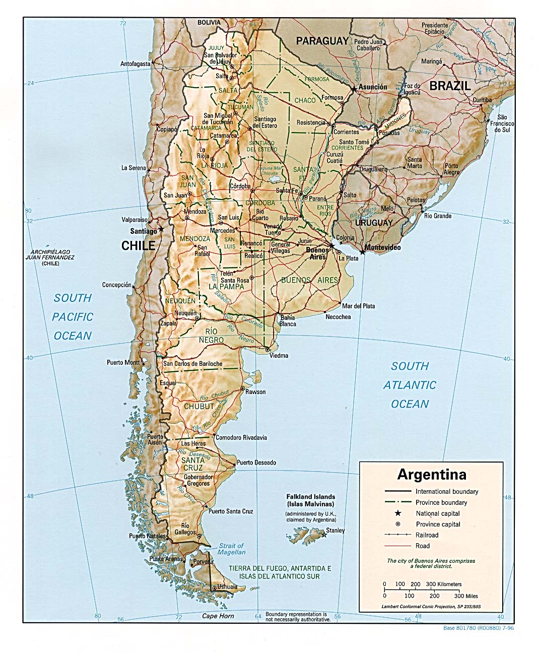
The geography of Argentina is heavily diverse, consisting of the Andes Mountains, pampas, and various rivers and lakes. Bordered by the Andes in the west and the South Atlantic Ocean to the east, its neighbouring countries are Chile to the west, Bolivia and Paraguay to the north, and Brazil and Uruguay to the northeast.

Contents

In terms of area, Argentina is the second largest country in South America after Brazil, and the eighth largest country in the world. Its total area is 2,780,400 km2 (1,073,500 sq mi). Argentina claims a section of Antarctica (Argentine Antarctica) that is subject to the Antarctic Treaty. Argentina also asserts claims to several British South Atlantic islands.

With a population of 46.6 million, [2] Argentina ranks as the world's 31st most populous country as of 2010.

General characteristics

Argentina is located in the Southern part of South America, being the biggest country in the Southern Cone. It limits with Chile to the west and south, with the Argentina–Chile border being its largest one. [3] [4] Bolivia and Paraguay limit Argentina in the north, the Argentina–Paraguay border is the second largest one. [4] The northern half of Argentina limits with Brazil and Uruguay to the east, and the southern half with the Atlantic Ocean. The Falkland Islands, a British Overseas Territory, are located to the east of southern Argentina, across the ocean. [5] Argentina is located at a strategic point over the Strait of Magellan, the link between the Atlantic and Pacific oceans. [1]

Argentina has a land area of 2,780,400 km². It is the 8th largest country in the world, between India and Kazakhstan. It is the second largest country in South America, after Brazil, and the fourth largest in the Americas after Brazil, Canada, and the United States. [6] The surface is almost eight times that of Germany, and four times that of Texas, [5] and three-tenths the size of the United States. [1] The Argentine Sea, the maritime claims of Argentina, include an exclusive economic zone of 200 nm. [1]

The terrain is composed of plains to the East, with the Andes mountain range at the western border. Climate is mostly temperate, with an arid area at southeast Patagonia and subantartic climate at the southwest. The Iguazu Falls, one of the New 7 Wonders of Nature, is the largest waterfall system in the world. It is located at the frontier with Brazil, with both countries having part of it. [1]

As for the national extreme points, the northernmost point is the confluence of the Grande de San Juan river and the Mojinete river, at the Jujuy Province. [4] The southernmost point is the Cape San Pío at the Tierra del Fuego Province, at the entry point of the Beagle Channel. [4] The westernmost point is located at the Los Glaciares National Park, at the Santa Cruz Province. [4] The easternmost point is the "Hito V" (CONALI), located at Bernardo de Irigoyen, Misiones. [4] The highest point of Argentina is the Aconcagua mountain at the Mendoza Province, with 6962 m., which is also the highest point of South America. [1] The lowest point is Laguna del Carbón, at the Santa Cruz Province. [1]

In Argentina forest cover is about 10% of the total land area, equivalent to 28,573,000 ha of forests in 2020, down from 35,204,000 ha in 1990. In 2020, naturally regenerating forest covered 27,137,000 ha and planted forest covered 1,436,000 ha. Of the naturally regenerating forest 0% was reported to be primary forest (consisting of native tree species with no clearly visible indications of human activity) and about 7% was found within protected areas. For the year 2015, 0% of the forest area was reported to be under public ownership, 4% private ownership and 96% with ownership listed as other or unknown. [7] [8]

Regions

Regions of Argentina:
.mw-parser-output .legend{page-break-inside:avoid;break-inside:avoid-column}.mw-parser-output .legend-color{display:inline-block;min-width:1.25em;height:1.25em;line-height:1.25;margin:1px 0;text-align:center;border:1px solid black;background-color:transparent;color:black}.mw-parser-output .legend-text{}
Northwest
Chaco Region
Mesopotamia
Cuyo
Sierras pampeanas
Pampas
Dry Pampas
Patagonia
Antarctica islands
. Regiones geograficas arg.png
Regions of Argentina:
   Northwest
   Cuyo
   Pampas
   Patagonia
   Antarctica islands
.

The Cuyo region is located in the middle-west of the country. It comprises the west of Catamarca and La Rioja, most of San Juan, and the center and north of Mendoza. It limits to the Argentine Northwest to the north, Chile to the west, the Pampas to the east, and the Patagonia to the south. Most of the region is part of the Andes mountain range. It is divided in the occidental range, whose mountains are largely uniform, and the oriental range, with more varied geographic features. The snow line is located at 5000 m. of altitude. There is a corridor between mountains with rivers and lakes, irrigated by the snow that melts during summer. Most of those rivers become tributaries of the Desaguadero River. The climate is arid, with few rains and even few clouds. There are few native trees, and most vegetation are bushes adapted to the climate. The fauna includes camelids such as guanacos and vicuñas, and vultures like the Andean condor. [9]

The Gran Chaco region is located in the north of the country. It comprises the provinces of Formosa, Chaco, Santiago del Estero and north of Santa Fe. It limits to Bolivia and Paraguay to the north, the Argentine Norwest to the west, the Pampas to the south, and Paraguay and the Mesopotamia to the east. The land is completely flat, which leads to an abundance of swamps and vernal pools. The most important rivers are the Paraguay and Parana, and their tributaries Pilcomayo and Bermejo. The climate is subtropical, with a dry season to the west and without it to the east. There are xerophilous forests. [10]

The Mesopotamia region is located in the east of the country, between the Parana and Uruguay rivers. It comprises the provinces of Misiones, Corrientes, and Entre Ríos. It limits to Paraguay and Brazil to the north, Gran Chaco and pampas to the west, Brazil and Uruguay to the east, and the pampas to the south. Most of it is a plain, and the rivers end at the Río de la Plata, making the Río de la Plata Basin. [11]

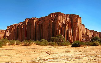
The Argentine Northwest region comprises the provinces of Jujuy, Salta, Tucumán, Catamarca, and La Rioja. It limits to Bolivia to the north, Chile to the west, Cuyo to the south and the Gran Chaco to the east. The region is divided into three subregions, the Puna to the west, valleys in the middle, and hills to the east. The Puna is a high treeless plateau, which continues to the west into the Atacama Desert in Chile. It has characteristic salt pans. There is very little water in that area, mostly in temporary streams. The hills and valleys are wetter, with the rain that comes from the east, and includes rivers such as the Salado and Bermejo. Climate is arid in the Puna and subtropical in the east. [12]

Argentina's provinces are divided in seven zones regarding climate and terrain. From North to South, West to East:

Land use

Mountains and hills

Water resources

In Argentina, the fluvial net is integrated by many systems of different economic relevance, which could be measured by their amount of flow and navigability. Water flow relevance is based on its potential to be used for irrigation and as a source of energy. Depending on where the water streams drain, rivers and creeks could be classified into three different kinds of watersheds:

On the other hand, lakes and lagoons are permanent accumulations of water over impervious depressions. Their difference is mainly based on their extension and depth. They are very important for stream regulation, as a source of energy, tourist attraction and its ichthyologic wealth. In Argentina, all major lakes are in Patagonia. [13]

Rivers

Major rivers in Argentina include the Pilcomayo, Paraguay, Bermejo, Colorado, Río Negro, Salado, Uruguay and the largest river, the Paraná. The latter two flow together before meeting the Atlantic Ocean, forming the estuary of the Río de la Plata. Regionally important rivers are the Atuel and Mendoza in the homonymous province, the Chubut in Patagonia, the Río Grande in Jujuy, and the San Francisco River in Salta.

Lakes

There are several large lakes in Argentina, many of them in Patagonia. Among these are lakes Argentino and Viedma in Santa Cruz, Nahuel Huapi in Río Negro and Fagnano in Tierra del Fuego, and Colhué Huapi and Musters in Chubut. Lake Buenos Aires and O'Higgins/San Martín Lake are shared with Chile. Mar Chiquita, Córdoba, is the largest saltwater lake in the country. There are numerous reservoirs created by dams. Argentina features various hot springs, such as those at Termas de Río Hondo with temperatures between 30 °C and 65 °C.

A recent global remote sensing analysis suggested that there were 3,091 km2 of tidal flats in Argentina, making it the ninth ranked country in terms of how much tidal flat occurs there. [14]

Climate

Argentina is subject to a variety of climates. The north of the country, including latitudes in and below the Tropic of Capricorn, is characterized by very hot, wet summers (which result in a number of swamp lands) with mild drier winters, and is subject to periodic droughts during the winter season.

Central Argentina has hot summers with tornadoes and thunderstorms (in western Argentina producing some of the world's largest hail), and cool winters. The southern regions have warm summers and cold winters with heavy snowfall, especially in mountainous zones. Higher elevations at all latitudes experience cooler conditions.

Political geography

Argentina borders six countries with one, near the Falkland Islands, being a maritime border with the United Kingdom. Its largest and the world's second largest international land border is with Chile , which is 5,308 km (3,298 mi) long. The Argentina–Paraguay border is 1,699 km (1,056 mi) long. [15] [16]

Strategic importance:

Territorial claims

National parks

The National Parks of Argentina make up a network of thirty national parks in Argentina. The parks cover a very varied set of terrains and biotopes, from Baritú National Park on the northern border with Bolivia to Tierra del Fuego National Park in the far south of the continent (see List of national parks of Argentina).

The creation of the National Parks dates back to the 1903 donation of 73 square kilometers of land in the Lake District in the Andes foothills by Francisco Moreno. This formed the nucleus of a larger protected area in Patagonia around San Carlos de Bariloche. In 1934, a law was passed creating the National Parks system, formalizing the protected area as the Nahuel Huapi National Park and creating the Iguazú National Park. The National Park Police Force was born, enforcing the new laws preventing tree-felling and hunting. Their early task was largely to establish national sovereignty over these disputed areas and to protect borders.

Five further national parks were declared in 1937 in Patagonia and the service planned new towns and facilities to promote tourism and education. Six more were declared by 1970.

In 1970 a new law established new categories of protection, so that there now were National Parks, National Monuments, Educational Reserves and Natural Reserves. Three national parks were declared in the 1970s. In 1980, another new law affirmed the status of national parks - this law is still in place. The 1980s saw the service reaching out to local communities and local government to help in the running and development of the national parks. Ten more national parks were created with local co-operation, sometimes at local instigation. In 2000, Mburucuyá and Copo National Parks were declared, and El Leoncito natural reserve was upgraded to a national park.

The headquarters of the National Park Service are in downtown Buenos Aires, on Santa Fe Avenue. A library and information center are open to the public. The administration also covers the national monuments, such as the Petrified Forest, and natural and educational reserves.

See also

Related Research Articles

<span class="mw-page-title-main">Geography of Paraguay</span>

Paraguay is a country in South America, bordering Argentina, Bolivia and Brazil. The Paraguay River divides the country into strikingly different eastern and western regions. Both the eastern region and the western region gently slope toward and are drained into the Paraguay River, which separates and unifies the two regions. With the Paraneña region reaching southward and the Chaco extending to the north, Paraguay straddles the Tropic of Capricorn and experiences both subtropical and tropical climates.

<span class="mw-page-title-main">Tierra del Fuego</span> Archipelago off the south of South America

Tierra del Fuego is an archipelago off the southernmost tip of the South American mainland, across the Strait of Magellan.

<span class="mw-page-title-main">Patagonia</span> Geographical region in South America

Patagonia is a geographical region that encompasses the southern end of South America, governed by Argentina and Chile. The region comprises the southern section of the Andes Mountains with lakes, fjords, temperate rainforests, and glaciers in the west and deserts, tablelands, and steppes to the east. Patagonia is bounded by the Pacific Ocean on the west, the Atlantic Ocean to the east, and many bodies of water that connect them, such as the Strait of Magellan, the Beagle Channel, and the Drake Passage to the south.

<span class="mw-page-title-main">Río Negro Province</span> Province of Argentina

Río Negro is a province of Argentina, located in northern Patagonia. Neighboring provinces are from the south clockwise Chubut, Neuquén, Mendoza, La Pampa and Buenos Aires. To the east lies the Atlantic Ocean.

<span class="mw-page-title-main">Tourism in Argentina</span>

Argentina has a vast territory and a variety of climates and microclimates ranging from tundra and polar in the south to the tropical climate in the north, through a vast expanse of temperate climate. Natural wonders include the Aconcagua, the highest mountain in the world outside the Himalayas, the widest river and estuary of the planet, the Iguazú Falls, the Humid Pampas, and the Argentine Sea. Visitors enjoy the culture, customs and Argentine cuisine.

<span class="mw-page-title-main">Salta Province</span> Province of Argentina

Salta is a province of Argentina, located in the northwest of the country. Neighboring provinces are from the east clockwise Formosa, Chaco, Santiago del Estero, Tucumán and Catamarca. It also surrounds Jujuy. To the north it borders Bolivia and Paraguay and to the west lies Chile.

<span class="mw-page-title-main">Neuquén Province</span> Province of Argentina

Neuquén is a province of Argentina, located in the west of the country, at the northern end of Patagonia. It borders Mendoza Province to the north, Rio Negro Province to the southeast, and Chile to the west. It also meets La Pampa Province at its northeast corner.

<span class="mw-page-title-main">Bariloche</span> City in Río Negro, Argentina

San Carlos de Bariloche, usually known as Bariloche, is a city in the province of Río Negro, Argentina, situated in the foothills of the Andes on the southern shores of Nahuel Huapi Lake. It is located within the Nahuel Huapi National Park. After development of extensive public works and Alpine-styled architecture, the city emerged in the 1930s and 1940s as a major tourism centre with skiing, trekking and mountaineering facilities. In addition, it has numerous restaurants, cafés, and chocolate shops. The city had a permanent population of 108,205 according to the 2010 census. According to the latest statistics from 2015, the population is around 122,700, and a projection for 2020 estimates 135,704.

<span class="mw-page-title-main">Isla Grande de Tierra del Fuego</span> Island of Argentina and Chile

Isla Grande de Tierra del Fuego also formerly Isla de Xátiva is an island near the southern tip of South America from which it is separated by the Strait of Magellan. The western portion (61.4%) of the island is in Chile, while the eastern portion is in Argentina. It forms the major landmass in an extended group of islands or archipelago also known as Tierra del Fuego.

<span class="mw-page-title-main">Gran Chaco</span> Region of south-central Southern America

The Gran Chaco or Dry Chaco is a sparsely populated, hot and semiarid lowland tropical dry broadleaf forest natural region of the Río de la Plata basin, divided among eastern Bolivia, western Paraguay, northern Argentina, and a portion of the Brazilian states of Mato Grosso and Mato Grosso do Sul, where it is connected with the Pantanal region. This land is sometimes called the Chaco Plain.

<span class="mw-page-title-main">Humid Chaco</span> Terrestrial ecoregion in South America

The Humid Chaco is tropical grasslands, savannas, and shrublands ecoregion in South America. It lies in the basin of the Paraná River, covering portions of central Paraguay and northern Argentina, and with a small portion of southwestern Brazil and northwestern Uruguay. The natural vegetation is a mosaic of grasslands, palm savanna, and forest.

<span class="mw-page-title-main">Regions of Argentina</span>

The provinces of Argentina are often grouped into eight geographical regions.

<span class="mw-page-title-main">Tehuelche people</span> Ethnic group

The Tehuelche people, also called the Aónikenk, are an Indigenous people from eastern Patagonia in South America. In the 18th and 19th centuries the Tehuelche were influenced by Mapuche people, and many adopted a horseriding lifestyle. Once a nomadic people, the lands of the Tehuelche were colonized in the 19th century by Argentina and Chile, gradually disrupting their traditional economies. The establishment of large sheep farming estates in Patagonia was particularly detrimental to the Tehuelche. Contact with outsiders also brought in infectious diseases ushering deadly epidemics among Tehuelche tribes. Most existing members of the group currently reside in cities and towns of Argentine Patagonia.

<span class="mw-page-title-main">Patagonian Desert</span> Largest desert in Argentina

The Patagonian Desert, also known as the Patagonian Steppe, is the largest desert in Argentina and is the eighth-largest desert in the world by area, occupying approx. 673,000 square kilometres. It is located primarily in Argentina and is bounded by the Andes, to its west, and the Atlantic Ocean to its east, in the region of Patagonia, southern Argentina and areas of Chile. To the north the desert grades into the Cuyo Region and the Monte. The central parts of the steppe are dominated by shrubby and herbaceous plant species albeit to the west, where precipitation is higher, bushes are replaced by grasses. Topographically the deserts consist of alternating tablelands and massifs dissected by river valleys and canyons. The more western parts of the steppe host lakes of glacial origin and grades into barren mountains or cold temperate forests along valleys.

<span class="mw-page-title-main">Climate of Argentina</span>

The climate of Argentina varies from region to region, as the vast size of the country and wide variation in altitude make for a wide range of climate types. Summers are the warmest and wettest season in most of Argentina, except for most of Patagonia, where it is the driest season. The climate is warm in the north, cool in the center, and cold in the southern parts, that experience frequent frost and snow. Because the southern parts of the country are moderated by the surrounding oceans, the cold is less intense and prolonged than areas at similar latitudes in the northern hemisphere. Spring and autumn are transition seasons that generally feature mild weather.

<span class="mw-page-title-main">Boundary Treaty of 1881 between Chile and Argentina</span> Territorial settlement

The Boundary Treaty of 1881 between Argentina and Chile was signed on 23 July 1881 in Buenos Aires by Bernardo de Irigoyen, for Argentina, and Francisco de Borja Echeverría, for Chile, with the aim of establishing a precise border between the two countries based on the uti possidetis juris principle. Despite dividing largely unexplored lands, the treaty laid the groundwork for nearly all of Chile's and Argentina's 5600 km current border.

<span class="mw-page-title-main">Environment of Argentina</span>

The Environment of Argentina is characterised by high biodiversity.

<span class="mw-page-title-main">Nahuel Huapi National Park</span> National park in Argentina

Nahuel Huapi National Park is the oldest national park in Argentina, established in 1922 as Parque Nacional de Sud and reconfiguered in 1934. It surrounds Nahuel Huapi Lake in the foothills of the Patagonian Andes. The largest of the national parks in the region, it has an area of 7,050 km2 (2,720 sq mi), or nearly 2 million acres. Its landscapes represent the north Patagonian Andean Zone consisting of three types, namely, the Altoandino, the Andino-Patagónico and the Patagonian steppe. It also represents small parts of the Valdivian Rainforest.

<span class="mw-page-title-main">Climatic regions of Argentina</span> Overview of climatic regions of Argentina

Due to its vast size and range of altitudes, Argentina possesses a wide variety of climatic regions, ranging from the hot subtropical region in the north to the cold subantarctic in the far south. The Pampas region lies between those and featured a mild and humid climate. Many regions have different, often contrasting, microclimates. In general, Argentina has four main climate types: warm, moderate, arid, and cold in which the relief features, and the latitudinal extent of the country, determine the different varieties within the main climate types.

References

  1. 1 2 3 4 5 6 7 8 9 10 11 12 13 "The world Factbook: Argentina". The World Factbook . Central Intelligence Agency . Retrieved December 13, 2013.
  2. "CIA World Factbook: Argentina" . Retrieved 2012-06-26.
  3. "INDEC: Instituto Nacional de Estadística y Censos de la República Argentina". www.indec.gob.ar.
  4. 1 2 3 4 5 6 "Límites". September 2020.
  5. 1 2 "Administrative Map of Argentina, South America". Nations Online. Retrieved August 5, 2024.
  6. "Extensión" [Extension] (in Spanish). Argentina.gob.ar. Retrieved August 9, 2024.
  7. Terms and Definitions FRA 2025 Forest Resources Assessment, Working Paper 194. Food and Agriculture Organization of the United Nations. 2023.
  8. "Global Forest Resources Assessment 2020, Argentina". Food Agriculture Organization of the United Nations.
  9. Menutti, pp. 51-53
  10. Menutti, pp. 55-57
  11. Menutti, pp. 59-61
  12. Menutti, pp. 63-65
  13. Carlevari and Carlevari (2007).{{cite book}}: Missing or empty |title= (help)
  14. Murray, N.J.; Phinn, S.R.; DeWitt, M.; Ferrari, R.; Johnston, R.; Lyons, M.B.; Clinton, N.; Thau, D.; Fuller, R.A. (2019). "The global distribution and trajectory of tidal flats". Nature. 565 (7738): 222–225. doi:10.1038/s41586-018-0805-8. PMID   30568300. S2CID   56481043.
  15. "INDEC: Instituto Nacional de Estadística y Censos de la República Argentina". www.indec.gob.ar.
  16. "Límites". September 2020.

Bibliography