Geography of Suriname

Last updated

Geography of Suriname
PAT - Suriname.gif
Continent South America
Region Caribbean
Coordinates 4°00′N56°00′W / 4.000°N 56.000°W / 4.000; -56.000
Area Ranked 90th
  Total163,820 km2 (63,250 sq mi)
  Land95.33%
  Water4.67%
Coastline386 km (240 mi)
Borderstotal length 1,707 km (1,061 mi)
Highest point Juliana Top
1,230 meters (4,040 ft)
Lowest point Caribbean Sea
0 metres (0 ft)
Longest river Courantyne River
724 km (450 mi)
Largest lake Brokopondo Reservoir
1,560 km (970 mi)
Exclusive economic zone127,772 km2 (49,333 sq mi)
Topographic map of Suriname and EEZ (exclusive economic zone). Suriname geology NL annot.svg
Topographic map of Suriname and EEZ (exclusive economic zone).

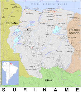
Suriname is located in the northern part of South America and is part of Caribbean South America, bordering the North Atlantic Ocean, between French Guiana and Guyana. It is mostly covered by tropical rainforest, containing a great diversity of flora and fauna that, for the most part, are increasingly threatened by new development. There is a relatively small population, most of which live along the coast.

Contents

There are currently two unresolved border disputes that affect the geography of Suriname, namely the Tigri Area in the southwestern region near Guyana and also the Marouini/Litani region with French Guiana in the southeast.

Location

Geographic coordinates: 4°00′N56°00′W / 4.000°N 56.000°W / 4.000; -56.000

Continent: South America

Area

Total:163,820 square kilometers (63,250 sq mi)
Land:156,000 square kilometers (60,000 sq mi)
Water:7,820 square kilometers (3,020 sq mi)

Area - comparative: See order of magnitude 1 E+11 m². Slightly larger than Tunisia.

Land boundaries

Suriname with the disputed areas, including the Tigri Area controlled by Guyana and southeastern area controlled by French Guiana. Suriname1991 Karte umstrittene Gebiete.jpg
Suriname with the disputed areas, including the Tigri Area controlled by Guyana and southeastern area controlled by French Guiana.
Suriname (circa 1914) in the Encyclopedia of the Dutch West Indies, by Surinamese cartographer Herman Benjamins and Dutch ethnographer Johannes Snelleman. Encyclopaedie van Nederlandsch West-Indie-Surinam north-Benj004ency01ill stitched.jpg
Suriname (circa 1914) in the Encyclopedia of the Dutch West Indies, by Surinamese cartographer Herman Benjamins and Dutch ethnographer Johannes Snelleman.

Total:1,703 kilometers (1,058 mi)

Border countries:

Coastline:386 kilometers (240 mi)

Maritime claims

Exclusive economic zone:127,772 km2 (49,333 sq mi) and 200  nmi (370.4 km; 230.2 mi)

Territorial sea:12 nmi (22.2 km; 13.8 mi)

Climate and climate change

Suriname has a tropical rainforest climate and a tropical monsoon climate, with hot humid conditions year-round.

Climate change in both Suriname and the wider world is leading to hotter temperatures and more extreme weather. As a fairly poor country, its contributions to global climate change have been limited. Suriname has a large forest cover, the country has been running a carbon negative economy since 2014. [1] Hotter temperatures [2] and changes in precipitation trends [3] are predicted because of climate change.

Climate data for Paramaribo
MonthJanFebMarAprMayJunJulAugSepOctNovDecYear
Record high °C (°F)33
(91)
34
(93)
35
(95)
37
(99)
37
(99)
36
(97)
37
(99)
37
(99)
36
(97)
37
(99)
36
(97)
36
(97)
37
(99)
Mean daily maximum °C (°F)30
(86)
30
(86)
30
(86)
31
(88)
30
(86)
31
(88)
31
(88)
32
(90)
33
(91)
33
(91)
32
(90)
30
(86)
31
(88)
Daily mean °C (°F)26
(79)
26
(79)
26
(79)
27
(81)
27
(81)
27
(81)
27
(81)
27
(81)
28
(82)
28
(82)
27
(81)
26
(79)
27
(81)
Mean daily minimum °C (°F)22
(72)
22
(72)
22
(72)
22
(72)
23
(73)
22
(72)
22
(72)
23
(73)
23
(73)
23
(73)
23
(73)
22
(72)
22
(72)
Record low °C (°F)17
(63)
17
(63)
17
(63)
18
(64)
19
(66)
20
(68)
20
(68)
15
(59)
21
(70)
20
(68)
21
(70)
18
(64)
15
(59)
Average rainfall mm (inches)200
(7.9)
140
(5.5)
150
(5.9)
210
(8.3)
290
(11.4)
290
(11.4)
230
(9.1)
170
(6.7)
90
(3.5)
90
(3.5)
120
(4.7)
180
(7.1)
2,160
(85)
Source: Weatherbase [4]
Climate data for Nieuw Nickerie
MonthJanFebMarAprMayJunJulAugSepOctNovDecYear
Record high °C (°F)32.5
(90.5)
32.4
(90.3)
32.5
(90.5)
33.2
(91.8)
34.8
(94.6)
34.0
(93.2)
34.5
(94.1)
35.6
(96.1)
35.4
(95.7)
36.3
(97.3)
34.9
(94.8)
33.8
(92.8)
36.3
(97.3)
Mean daily maximum °C (°F)28.9
(84.0)
29.0
(84.2)
29.2
(84.6)
29.5
(85.1)
29.8
(85.6)
29.8
(85.6)
30.3
(86.5)
31.1
(88.0)
31.7
(89.1)
31.7
(89.1)
30.9
(87.6)
29.8
(85.6)
30.1
(86.2)
Daily mean °C (°F)26.5
(79.7)
26.6
(79.9)
26.9
(80.4)
27.2
(81.0)
27.2
(81.0)
27.1
(80.8)
27.2
(81.0)
27.8
(82.0)
28.3
(82.9)
28.2
(82.8)
27.8
(82.0)
27.0
(80.6)
27.3
(81.1)
Mean daily minimum °C (°F)23.5
(74.3)
23.7
(74.7)
24.0
(75.2)
24.2
(75.6)
24.2
(75.6)
23.9
(75.0)
23.7
(74.7)
24.0
(75.2)
24.2
(75.6)
24.0
(75.2)
23.9
(75.0)
23.7
(74.7)
24.0
(75.2)
Record low °C (°F)18.3
(64.9)
18.2
(64.8)
19.1
(66.4)
19.9
(67.8)
20.7
(69.3)
20.6
(69.1)
20.9
(69.6)
19.9
(67.8)
20.9
(69.6)
20.3
(68.5)
20.0
(68.0)
20.1
(68.2)
18.2
(64.8)
Average rainfall mm (inches)191
(7.5)
114
(4.5)
111
(4.4)
191
(7.5)
246
(9.7)
316
(12.4)
266
(10.5)
168
(6.6)
61
(2.4)
61
(2.4)
79
(3.1)
176
(6.9)
1,980
(77.9)
Average relative humidity (%)82818080828382807878798281
Source: Deutscher Wetterdienst [5]

Terrain

Most of the country is made up of rolling hills, but there is a narrow coastal plain that has swampy terrain.

A recent global remote sensing analysis suggested that there were 781 km² of tidal flats in Suriname, making it the 34th ranked country in terms of tidal flat area. [6]

Elevation extremes

Lowest point: Unnamed location in the coastal plain - 2 meters (6.6 ft) below Sea Level.
Highest point: Juliana Top - 1,230 meters (4,040 ft)

Natural resources

Timber, hydropower, fish, forests, hydroelectric potential, kaolin, shrimp, bauxite and gold. Small amounts of nickel, copper, platinum and iron ore. It also has sizeable oil.

Water

The country has one large reservoir, the Brokopondo Reservoir. Several rivers run through it, including the Suriname River, Nickerie River and Maroni or Marowijne River.

Land use

(2018 Estimates)

Arable land: 0.4%
Permanent crops: 0.0%
permanent pasture: 0.1%
forest: 94.6%
Other: 4.9%

Irrigated land

510 square kilometers (200 sq mi) (2003)

Natural hazards

Tropical Showers, no hurricanes.[ citation needed ]

Environment

Share of forest area in total land area, top countries (2021). Suriname has the highest percentage of forest cover in the world. Share Of Forest Area In Total Land Area, Top Countries (2021).svg
Share of forest area in total land area, top countries (2021). Suriname has the highest percentage of forest cover in the world.

Current issues

Deforestation is a real problem as timber is cut for export. There is also a lot of pollution of inland waterways by small-scale mining activities.

Climate change

Climate change in Suriname is leading to warmer temperatures and more extreme weather events in Suriname. As a relatively poor country, its contributions to global climate change have been limited. Because of the large forest cover, the country has been running a carbon negative economy since 2014. [7]

Suriname was the second country to update its Nationally Determined Contributions in 2020. [8]

International agreements

Suriname has agreed to the following agreements: Biodiversity, Climate Change, Endangered Species, Kyoto Protocol, Law of the Sea, Marine Dumping--London Convention, Marine Dumping--London Protocol, Ozone Layer Protection, Paris Accords Ship Pollution, Tropical Timber 94, Wetlands, Whaling [9]

Extreme points

See also

Related Research Articles

<span class="mw-page-title-main">Geography of Brazil</span> Overview of the geography of Brazil

The country of Brazil occupies roughly half of South America, bordering the Atlantic Ocean. Brazil covers a total area of 8,514,215 km2 (3,287,357 sq mi) which includes 8,456,510 km2 (3,265,080 sq mi) of land and 55,455 km2 (21,411 sq mi) of water. The highest point in Brazil is Pico da Neblina at 2,994 m (9,823 ft). Brazil is bordered by the countries of Argentina, Bolivia, Colombia, Guyana, Paraguay, Peru, Suriname, Uruguay, Venezuela, and France.

<span class="mw-page-title-main">Geography of Ecuador</span>

Ecuador is a country in western South America, bordering the Pacific Ocean at the Equator, for which the country is named. Ecuador encompasses a wide range of natural formations and climates, from the desert-like southern coast to the snowcapped peaks of the Andes mountain range to the plains of the Amazon Basin. Cotopaxi in Ecuador is one of the world's highest active volcanos. It also has a large series of rivers that follow the southern border and spill into the northwest area of Peru.

French Guiana is an overseas region of France, located on the northern coast of South America between Suriname and Brazil. The country is part of Caribbean South America and borders the North Atlantic Ocean. It has low-lying plains with small mountains to the south. Its climate is split between tropical rainforest and tropical monsoon. French Guiana is mostly unsettled and has low land use.

<span class="mw-page-title-main">Geography of Papua New Guinea</span> Geographical features of Papua New Guinea

The geography of Papua New Guinea describes the eastern half of the island of New Guinea, the islands of New Ireland, New Britain and Bougainville, and smaller nearby islands. Together these make up the nation of Papua New Guinea in tropical Oceania, located in the western edge of the Pacific Ocean.

<span class="mw-page-title-main">Transport in Suriname</span>

The Republic of Suriname has a number of forms of transport. Transportation emissions are an increasing part of Suriname's contributions to climate change, as part of the Nationally Determined Contributions for the Paris Agreement, Suriname has committed to emissions controls for vehicles and increased public transit investment.

<span class="mw-page-title-main">Geography of Venezuela</span> Geography of Venezuela

Venezuela is a country in South America, bordering the Caribbean Sea and the North Atlantic Ocean, between Colombia and Guyana. It is situated on major sea and air routes linking North and South America. Located at the northernmost end of South America, Venezuela has a total area of 912,050 km2 (352,140 sq mi) and a land area of 882,050 km2 (340,560 sq mi). It is the 32nd largest country and is slightly smaller than Egypt, or half the size of Mexico. Shaped roughly like an inverted triangle, the country has a 2,800 km (1,700 mi) long coastline. It is bound on the north by the Caribbean Sea and the Atlantic Ocean, on the east by Guyana, on the south by Brazil, and on the west by Colombia. It has the 55th largest Exclusive Economic Zone of 471,507 km2 (182,050 sq mi). Its maritime territory borders Trinidad and Tobago, Dominica, the Dominican Republic, Grenada, St. Kitts and Nevis, St. Vincent and the Grenadines, France, the United Kingdom, the Netherlands, and the United States. Venezuela also claims the region of Guayana Esequiba, currently under the control of Guyana.

<span class="mw-page-title-main">Geography of Fiji</span>

Fiji is a group of volcanic islands in the South Pacific, lying about 4,450 kilometres (2,765 mi) southwest of Honolulu and 1,770 km (1,100 mi) north of New Zealand. Of the 332 islands and 522 smaller islets making up the archipelago, about 106 are permanently inhabited. The total land size is 18,272 km2 (7,055 sq mi). It has the 26th largest Exclusive Economic Zone of 1,282,978 km2 (495,361 sq mi).

The Geography of Guyana comprises the physical characteristics of the country in Northern South America and part of Caribbean South America, bordering the North Atlantic Ocean, between Suriname and Venezuela, with a land area of approximately 214,969 square km. The country is situated between 1 and 9 north latitude and between 56 and 62 west longitude. With a 459 km (285 mi)-long Atlantic coastline on the northeast, Guyana is bounded by Venezuela on the west, Brazil on the west and south, and Suriname on the east.

<span class="mw-page-title-main">Tumucumaque Mountains National Park</span> National park of Brazil

The Tumucumaque Mountains National Park is situated in the Amazon Rainforest in the Brazilian states of Amapá and Pará. It is bordered to the north by French Guiana and Suriname.

<span class="mw-page-title-main">Nickerie District</span> District of Suriname

Nickerie is a district of Suriname, on the north-west coast. Nickerie's capital city is Nieuw-Nickerie. Another town is Wageningen. The district borders the Atlantic Ocean to the north, the Surinamese district of Coronie to the east, the Surinamese district of Sipaliwini to the south and the region of East Berbice-Corentyne in Guyana to the west.

<span class="mw-page-title-main">Sipaliwini District</span> District of Suriname

Sipaliwini is the largest district of Suriname, located in the south. Sipaliwini is the only district that does not have a regional capital, as it is directly administered by the national government in Paramaribo. Sipaliwini District includes disputed areas, with the southwestern region controlled and administered by Guyana, whereas the southeastern region is controlled by French Guiana.

<span class="mw-page-title-main">Courantyne River</span> River in Suriname and Guyana

The Courantyne River is a river in northern South America in Suriname and Guyana. It is the longest river in the country and creates the border between Suriname and the East Berbice-Corentyne region of Guyana.

<span class="mw-page-title-main">Apoera</span> Place in Sipaliwini District, Suriname

Apoera, also Apura, is a town in western Suriname. The village has a population of 777 people as of 2020. It is the final destination of the Southern East-West Link. 24 kilometres (15 mi) north-west on the other side of the Courantyne River lies the Guyanese village of Orealla. The village is home to the Lokono tribe, but has been westernized. Due to the influx of people of Guyana, the languages used are English, and Sranan Tongo. Dutch is rarely spoken and the native language has all but disappeared. According to the oral tradition, Apoera was founded around 1920 by the Gordon family.

The Initiative for the Integration of the Regional Infrastructure of South America (IIRSA) is a development plan to link South America's economies through new transportation, energy, and telecommunications projects.

<span class="mw-page-title-main">Kabalebo</span> Resort in Sipaliwini District, Suriname

Kabalebo is a resort in Suriname, located in the Sipaliwini District. Its population at the 2012 census was 2,291.

<span class="mw-page-title-main">Guianan savanna</span> South American ecoregion

The Guianan savanna (NT0707) is an ecoregion in the south of Venezuela, Guyana and Suriname and the north of Brazil. It is in the Amazon biome. The savanna covers an area of rolling upland plains on the Guiana Shield between the Amazon and Orinoco basins. It includes forested areas, but these are shrinking steadily due to the effect of frequent fires, either accidental or deliberate. The ecoregion includes the Gran Sabana region of Venezuela.

Kumakahpan is a Wayana village in the Sipaliwini District of Suriname. The village lies on the banks of the Lawa River, which forms the border with French Guiana.

Climate change in Suriname is leading to warmer temperatures and more extreme weather events in Suriname. As a relatively poor country, its contributions to global climate change have been limited. Because of the large forest cover, the country has been running a carbon negative economy since 2014.

Camp Tigri or Camp Jaguar is a military camp and airstrip located in the Tigri Area. The area is disputed between Suriname and Guyana.

References

  1. "Suriname's climate promise, for a sustainable future". UN News. 2020-01-31. Retrieved 2020-06-07.
  2. "Historical Climate Data Suriname". climateknowledgeportal.worldbank.org. Archived from the original on 2020-06-07. Retrieved 2020-06-07.
  3. "Climate Data Projects Suriname". climateknowledgeportal.worldbank.org. Archived from the original on 2020-06-07. Retrieved 2020-06-07.
  4. "Weatherbase: Historical Weather for Paramaribo".
  5. "Klimatafel von Nickerie / Surinam" (PDF). Federal Ministry of Transport and Digital Infrastructure. Retrieved 21 June 2016.
  6. Murray, N.J.; Phinn, S.R.; DeWitt, M.; Ferrari, R.; Johnston, R.; Lyons, M.B.; Clinton, N.; Thau, D.; Fuller, R.A. (2019). "The global distribution and trajectory of tidal flats" . Nature. 565 (7738): 222–225. doi:10.1038/s41586-018-0805-8. PMID   30568300. S2CID   256767470.
  7. "Suriname's climate promise, for a sustainable future". UN News. 2020-01-31. Retrieved 2020-06-07.
  8. "Suriname's Second National Communication - In Progress | UNDP Climate Change Adaptation". www.adaptation-undp.org. Retrieved 2020-06-07.
  9. https://www.cia.gov/the-world-factbook/countries/suriname/#environment