Borders of Suriname

Last updated
The internationally recognized borders of Suriname upon independence in 1975. PAT - Suriname.gif
The internationally recognized borders of Suriname upon independence in 1975.
Detailed map of the disputed areas. Stroomgebied van de Coeroeni en Litani (1920).jpg
Detailed map of the disputed areas.

The borders of Suriname consist of land borders with three countries: Guyana, Brazil, and France (via French Guiana). The borders with Guyana and France are in dispute, but the border with Brazil has been uncontroversial since 1906.

Contents

Eastern border

The section of the Maroni River on which the Netherlands and France concluded a border treaty in 1915. KAARTEN SGD - Kaart van de Marowijne van af de samenvloeiing der Lawa en Tapanahoni tot Albina met de grensregeling tusschen Suriname en Fransch-Guyana.jpeg
The section of the Maroni River on which the Netherlands and France concluded a border treaty in 1915.

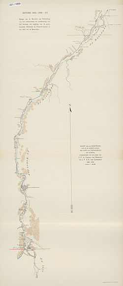
In 1860, the question was posed from the French side, which of the two tributary rivers of the Marowijne River (also called Maroni and Marowini) was the headwater, and thus the border. A joint French-Dutch commission was appointed to review the issue. The Dutch side of the commission consisted of J.H. Baron van Heerdt tot Eversberg, J.F.A. Cateau van Rosevelt and August Kappler. Luits Vidal, Ronmy, Boudet and Dr. Rech composed the French side. In 1861 measurements were taken, which produced the following result: the Lawa had a flow rate of 35,960 m3/minute at a width of 436 m; the Tapanahony had a flow rate of 20,291 m3/minute at a width of 285  m. Thus, the Lawa River was the headwater of the Maroni River.

There were no problems with this decision until 1885, when the discovery of gold in the area between the Lawa and the Tapanahony created a new border conflict. On November 29, 1888, France and the Netherlands reached an agreement that the conflict should be subject to arbitration. Tsar Alexander III of Russia, acting as the arbitrator, decided that the Lawa was the headwater of the Maroni, and thus should be considered the border. The Netherlands and France concluded a border treaty on this section of the river on 30 September 1915. A protocol delineating the border from the mouth of the Maroni up to the village of Antecume Pata was attached to this treaty on 15 March 2021. [1]

However, neither the 1915 treaty nor the 2021 protocol determines which river is the source of the Lawa. The Netherlands considered the Malani (Dutch: Marowijnekreek) to be the source of the Lawa; the French considered the Litani, located further to the west, to be the source of the Lawa. This issue has still not been resolved. [2]

The Litani originates in the Tumuk Humak Mountains at approximately 2½° N 55° W; along its path it is fed by Koele Koelekreek, the Lokekreek, the Mapaonikreek and the Oelemari River.

The Malani also has its source in the Tumuk Humak Mountains, at approximately 2° N, 54° W; it also absorbs the Koelebreek, among others.

Western border

The boundaries of British Guiana according to the Schomburgk survey. Boundary lines of British Guiana 1896.jpg
The boundaries of British Guiana according to the Schomburgk survey.

According to an agreement between Suriname governor Cornelis van Aerssen van Sommelsdijck and Berbice governor Abraham van Pere both were Dutch colonies at the timethe border between the two colonies was located at Devil Creek, between the Berbice River and the Courantyne River. In 1799, however, Berbice governor Abraham Jacob van Imbijze van Batenburg and Suriname governor Jurriaan François de Friderici signed an agreement in which the western bank of the Courantyne River was demarcated as the boundary. All islands in the Courantyne, as well as the post at Orealla, were deemed to be in Suriname. [3] As the Anglo-Dutch Treaty of 1814 returned Suriname to Dutch rule in the boundaries of 1 January 1803, the Courantyne became the new boundary between British Guiana and Suriname.

New River Triangle

Suriname with the disputed areas. Suriname1991 Karte umstrittene Gebiete.jpg
Suriname with the disputed areas.

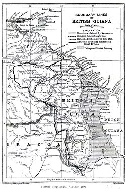
Robert Schomburgk surveyed British Guiana's borders in 1840. Taking the Courantyne River as the border, he sailed up to which he deemed its source, the Kutari River, in order to delineate the boundary. In 1871, however, Charles Barrington Brown discovered the New River or Upper Courantyne, which is the source of the Courantyne. Thus the New River Triangle dispute was born.

The tribunal which dealt with the Venezuelan crisis of 1895 also awarded the New River Triangle to British Guiana. The Netherlands, however, raised a diplomatic protest, claiming that the New River, and not the Kutari, was to be regarded as the source of the Courantyne and the boundary. The British government in 1900 replied that the issue was already settled by the long acceptance of the Kutari as the boundary.

In 1936, a Mixed Commission established by the British and Dutch government agreed to award the full width of the Courantyne River to Suriname, as per the 1799 agreement. The territorial sea boundary was deemed to prolongate 10° from Point No. 61, 6 km (3 nmi) from the shore. The New River Triangle, however, was completely awarded to Guyana. The treaty putting this agreement into law was never ratified, because of the outbreak of World War II. [4] That same year, the Dutch representative Conrad Carel Käyser signed an agreement with British and Brazilian representatives, placing the tri-point junction near the source of the Kutari River. [5]

Desiring to put the border issue to a closure before British Guiana would gain independence, the British government restarted negotiations in 1961. The British position asserted "Dutch sovereignty over the Corentyne River, a 10° line dividing the territorial sea, and British control over the New River Triangle." [6] The Netherlands replied with a formal claim to the New River Triangle, but with a thalweg boundary in the Courantyne River (the latter position has never been repeated by any Surinamese government). No agreements were made and Guyana became independent with its borders unresolved. In 1969 border skirmishes occurred between Guyanese forces and Surinamese militias at Camp Tigri. In 1971, the Surinamese and Guyanese government agreed in Trinidad to withdraw military forces from the Triangle. Until present Guyana hasn't withdrawn any of its military forces and still holds a firm grip on the New River Triangle.[ citation needed ]

Maritime dispute

The maritime boundary has long been disputed between Guyana and Suriname as well, and led in 2000 to skirmishes between Guyanese oil explorers and Surinamese coast guards. [7] Guyana claimed a thalweg boundary of the Courantyne River (probably inspired by the 1962 Dutch position), and a 35° line from the true North, from the mouth of the river. Suriname claimed sovereignty over the full width of the Courantyne and a 10° dividing line. Eventually a five-member tribunal of the Permanent Court of Arbitration was convened under the rules set out in Annex VII of the United Nations Convention on the Law of the Sea, which in 2007 set out its own boundary that differed from both parties' claims. The maritime border was finally settled by international arbitration. [8] The tribunal did award sovereignty over the full width of the Courantyne to Suriname, and also awarded Suriname with a 10° territorial sea boundary 6 km (3 nmi) from the shore, according to the 1936 agreement. The rest of the territorial sea boundary, which extends 22 km (12 nmi) from the shore under modern international law, and the boundary separating the Exclusive Economic Zones of both countries, was awarded according to the principle of equidistance, however. [9] [10]

Southern border

The southern border with Brazil is described in the Treaty of Limits of 1906 as "formed from the French border French Guiana to the British border British Guiana, the line of the drainage divide (watershed) between the Amazon basin to the south, and the basins of the rivers flowing into north to the Atlantic Ocean." The border described in the treaty was the result of an arbitration process that was headed by King Victor Emmanuel III of Italy. The treaty was signed in Rio de Janeiro on May 5, 1906. Brazil and the Netherlands both ratified the treaty in 1908.

Notes

Related Research Articles

<span class="mw-page-title-main">Foreign relations of Suriname</span>

As part of the foreign relations of Suriname, the country is a participant in numerous international organizations.

<span class="mw-page-title-main">British Guiana</span> British colony from 1814 to 1966

British Guiana was a British colony, part of the mainland British West Indies, which resides on the northern coast of South America. Since 1966 it has been known as the independent nation of Guyana.

<span class="mw-page-title-main">Dutch colonisation of the Guianas</span> 1581–1975 colonisation in South America

The Dutch began their colonisation of the Guianas, the coastal region between the Orinoco and Amazon rivers in South America, in the late 16th century. The Dutch originally claimed all of Guiana but—following attempts to sell it first to Bavaria and then to Hanau and the loss of sections to Portugal, Britain, and France—the section actually settled and controlled by the Netherlands became known as Dutch Guiana.

<span class="mw-page-title-main">The Guianas</span> Region in north-central South America

The Guianas, sometimes called by the Spanish loan-word Guayanas, is a region in north-eastern South America which includes the following three territories:

<span class="mw-page-title-main">Maroni (river)</span> River in South America, forming the border between Suriname and French Guiana

The Maroni or Marowijne is a river in South America that forms the border between French Guiana and Suriname.

<span class="mw-page-title-main">Courantyne River</span> River in Suriname and Guyana

The Courantyne/Corentyne/Corantijn River is a river in northern South America in Suriname and Guyana. It is the longest river in the country and creates the border between Suriname and the East Berbice-Corentyne region of Guyana.

<span class="mw-page-title-main">Berbice</span> 1627–1815 Dutch colony in South America

Berbice is a region along the Berbice River in Guyana, which was between 1627 and 1792 a colony of the Dutch West India Company and between 1792 and 1815 a colony of the Dutch state. After having been ceded to the United Kingdom of Great Britain and Ireland in the latter year, it was merged with Demerara-Essequibo to form the colony of British Guiana in 1831. It became a county of British Guiana in 1838 till 1958. In 1966, British Guiana gained independence as Guyana and in 1970 it became a republic as the Co-operative Republic of Guyana.

<span class="mw-page-title-main">Essequibo (colony)</span> 1616–1803 Dutch colony in South America

Essequibo was a Dutch colony in the Guianas and later a county on the Essequibo River in the Guiana region on the north coast of South America. It was a colony of the Dutch West India Company between 1616 and 1792 and a colony of the Dutch state from 1792 until 1815. It was merged with Demerara in 1812 by the British who took control. It formally became a British colony in 1815 until Demerara-Essequibo was merged with Berbice to form the colony of British Guiana in 1831. In 1838, it became a county of British Guiana till 1958. In 1966, British Guiana gained independence as Guyana and in 1970 it became a republic as the Co-operative Republic of Guyana. It was located around the lower course of the Demerara River, and its main settlement was Georgetown.

<span class="mw-page-title-main">Litani (Maroni tributary)</span> River in Suriname and French Guiana

The Litani or Itany is a river which forms part of the boundary between Suriname and French Guiana. It is a tributary, or the upper course, of the Maroni. The boundary is disputed, with Suriname also claiming land to the east of the river.

<span class="mw-page-title-main">Benzdorp</span> Place in Sipaliwini District, Suriname

Benzdorp is a village in the Sipaliwini District of Suriname. It is named after the English consul and bullion dealer H.J.W. Benz.

<span class="mw-page-title-main">Guyana</span> Caribbean country in South America

Guyana, officially the Co-operative Republic of Guyana, is a country on the northern mainland of South America. Guyana is an indigenous word which means "Land of Many Waters". The capital city is Georgetown. Guyana is bordered by the Atlantic Ocean to the north, Brazil to the south and southwest, Venezuela to the west, and Suriname to the east. With a land area of 215,000 km2 (83,000 sq mi), Guyana is the third-smallest sovereign state by area in mainland South America after Uruguay and Suriname, and is the second-least populous sovereign state in South America after Suriname; it is also one of the least densely populated countries on Earth. It has a wide variety of natural habitats and very high biodiversity.

<span class="mw-page-title-main">Coeroeni River</span> River in Brazil and Suriname

The Coeroeni River is a river in South America. It arises in the Tumuc-Humac Mountains, which forms the drainage divide between Pará, Brazil, and Suriname; from there it flows northward. The river is fed by the Aramatau, Kutari and Sipaliwini River. The Coeroeni goes on to form the border of the disputed Tigri Area by Guyana and Suriname. It eventually flows into the Courantyne River, which forms the international boundary between Guyana–Suriname.

<span class="mw-page-title-main">Surinam (Dutch colony)</span> Dutch plantation colony in the Guianas

Surinam, also unofficially known as Dutch Guiana, was a Dutch plantation colony in the Guianas, bordered by the equally Dutch colony of Berbice to the west, and the French colony of Cayenne to the east. It later bordered British Guiana from 1831 to 1966.

<span class="mw-page-title-main">Tigri Area</span> Disputed area between Guyana and Suriname

The Tigri Area is a wooded area that has been disputed by Guyana and Suriname since around 1840. It involves the area between the Upper Corentyne River, the Coeroeni River, and the Kutari River. This triangular area is known as the New River Triangle in Guyana. In 1969 the conflict ran high on, and since then it has been controlled by Guyana and claimed by Suriname. In 1971, both governments agreed that they would continue talks over the border issue and withdraw their military forces from the disputed triangle. Guyana has never held upon this agreement.

<span class="mw-page-title-main">Guyana–Suriname relations</span> Bilateral relations

Guyana – Suriname relations are the bilateral relations between Guyana and Suriname. Suriname has an embassy in Georgetown. Guyana has an embassy in Paramaribo. The Courentyne River makes up most of the border between the two countries.

<span class="mw-page-title-main">Lensidede</span> Place in Sipaliwini District, Suriname

Lensidede or Lessé Dédé, is a Surinamese village on an island in the Lawa River, near the Lensidede rapids after which the village was named. In the village live Wayana people.

Camp Tigri or Camp Jaguar is a military camp and airstrip located in the Tigri Area. The area is disputed between Suriname and Guyana.

<span class="mw-page-title-main">France–Suriname relations</span> Bilateral relations

Diplomatic relations between France and Suriname were established on 25 August 1976. Suriname and the French overseas department of French Guiana share a common border of 520 kilometres (320 mi). Suriname operates an embassy in Paris, a consulate in Cayenne, and an honorary consulate in Saint-Laurent-du-Maroni. France operates an embassy in Paramaribo, a consulate in Georgetown, Guyana, and an honorary consulate in Albina.

<span class="mw-page-title-main">Malani (river)</span> River in French Guiana, France / Suriname

The Malani, also Marouini, is a river in the disputed area between French Guiana and Suriname. According to Suriname, it is the border river, however France considers the Litani the border. The river has its source at Pic Coudreau in the Tumuk Humak Mountains. It has its mouth at the confluence with the Litany at Antecume Pata and continues its journey as the Lawa River. The Malani has a length of 245 kilometres (152 mi).

<span class="mw-page-title-main">Brazil–Suriname border</span> International border

The Brazil–Suriname border is the international border between Brazil and Suriname and has a length of 593 km (368 mi). It is the shortest international border that Brazil has with its neighbors. The Surinamese side of the border is made up entirely of Sipaliwini, the largest district in the country. The Brazilian side of the border is almost entirely contained by Pará, with only 52 km of the border in the east with Amapá.

References

Further reading