Borders of Brazil

Last updated
Brazil, administrative divisions (states) - en - colored.svg
Zoom in
BRA orthographic.svg
Zoom out
Location of Brazil within South America

The borders of Brazil are the international borders that Brazil shares with neighbouring countries. Brazil has terrestrial boundaries with nine countries of South America, and with the French Department of Guiana. Brazil has borders with every country in South America with the exception of Chile and Ecuador, totalling 16,885 kilometres (10,492 mi). [1] Brazil has the world's third longest land border, behind China and Russia.

Contents

Bordering countries

The lengths of the borders Brazil shares with different countries, running counter-clockwise around Brazil from French Guiana to Uruguay, are listed below: [1]

CountryLength (km)Bordering Brazilian states Border featuresBorder crossingsArticle link
Flag of France.svg  France (French Guiana)730 Amapá Oyapock Oyapock River Bridge Brazil–France border
Flag of Suriname.svg  Suriname 593 Amapá, Pará Defined by the Treaty of Limits as the drainage divide between the Amazon basin to the south, and the basins of the rivers flowing north to the Atlantic Ocean Brazil–Suriname border
Flag of Guyana.svg  Guyana 1,606 Pará, Roraima Takutu River, Ireng River Takutu River Bridge Brazil–Guyana border
Flag of Venezuela.svg  Venezuela 2,200 Amazonas, Roraima Highway BR-174 near the Brazilian city Pacaraima Brazil–Venezuela border
Flag of Colombia.svg  Colombia 1,644 Amazonas Japurá River, Apaporis River, Traíra River, Papurí River, Vaupés River, Içana River, Rio Cuiari The adjoining Colombian city Leticia and the Brazilian city Tabatinga Brazil–Colombia border
Flag of Peru.svg  Peru 2,995 Acre, Amazonas Acre River, Javary River, Amazon River, Santa Rosa River, Purus River, 10th parallel south Brazil-Peru Integration Bridge Brazil–Peru border
Bandera de Bolivia (Estado).svg  Bolivia 3,423 Acre, Mato Grosso, Mato Grosso do Sul, Rondônia Paraguay River, Tamengo Canal  [ es ], Mandioré Lake, Madeira River, Mamoré River, Abuna River, Acre River
  1. Wilson Pinheiro Binational Bridge (pt) (named Friendship Bridge by Bolivia) over the Acre River connecting the Bolivian city Cobija to the Brazilian city Brasiléia
  2. The adjoining Bolivian city Cobija and the Brazilian city Epitaciolândia
  3. A bridge over the Tamengo Canal  [ es ] joining the Bolivian city Puerto Quijarro and the Brazilian city Corumbá
Bolivia–Brazil border
Flag of Paraguay.svg  Paraguay 1,365 Mato Grosso do Sul, Paraná Paraná River, Itaipu Lake, Apa River, Paraguay River
  1. A bridge crossing the Apa River connecting the Brazilian city Bela Vista and the Paraguayan city Bella Vista Norte
  2. The adjoining Brazilian city Paranhos and the Paraguayan city Ypehú
  3. Itaipu Dam
  4. Friendship Bridge
Brazil–Paraguay border
Flag of Argentina.svg  Argentina 1,261 Paraná, Rio Grande do Sul, Santa Catarina Uruguay River, Pepiri-Guazu River, San Antonio River, Iguazu River, Iguazu Falls
  1. Tancredo Neves Bridge
  2. Integration Bridge
  3. Paso de los Libres – Uruguaiana International Bridge
  4. Peperi-Guazu International Bridge  [ es; pt ]
  5. The adjoining Argentinian city Bernardo de Irigoyen and Brazilian city Dionísio Cerqueira
  6. Commander Andresito International Bridge  [ es; pt ]
  7. An unnamed bridge over the San Antonio River linking the Brazilian city Santo Antônio do Sudoeste and the Argentinian city San Antonio
Argentina–Brazil border
Flag of Uruguay.svg  Uruguay 1,068 Rio Grande do Sul Chuí Stream, Highway 19, Lagoon Mirim, Jaguarão River, San Luis River, Quaraí River
  1. Baron of Mauá International Bridge
  2. The adjoining cities of Chuí (on the Brazilian side) and Chuy (on the Uruguayan side)
  3. The Brazilian and Uruguayan cities named Aceguá
  4. The adjoining Uruguayan city Rivera and Brazilian city Santana do Livramento
  5. International Bridge of Concord  [ es; pt ]
  6. Bella Unión - Barra do Quaraí International Bridge  [ es; pt; pt ]
Brazil-Uruguay border


Brazil's coastline with the Atlantic Ocean is 7,491 km, which is more than twice the length of its border with Bolivia, the longest land border. [1]

Border disputes

With Bolivia

With Uruguay

Water falls

With many of Brazil's borders defined by rivers, there are several water falls along the border. The most notable border water falls include the Iguazu Falls on the border with Argentina and Orinduik Falls on the border with Guyana.

Until 1982, the border with Paraguay contained the Guaíra Falls. The falls were submerged following the construction of the Itaipu Dam. [2]

Triple points

Tripoint between Brazil, Venezuela and Guyana located on Mount Roraima Triple Point, Mount Roraima.jpg
Tripoint between Brazil, Venezuela and Guyana located on Mount Roraima

.

A monument on the Brazilian side of the tripoint of Brazil, Argentina, and Paraguay (the exact tripoint is in the water) Marco das 3 fronteiras.jpg
A monument on the Brazilian side of the tripoint of Brazil, Argentina, and Paraguay (the exact tripoint is in the water)

With 10 bordering countries forming a single incomplete ring around Brazil, the borders of Brazil include 9 triple points (also called tripoints) in which the borders of three countries join at a single point. A few of the triple points are notable:

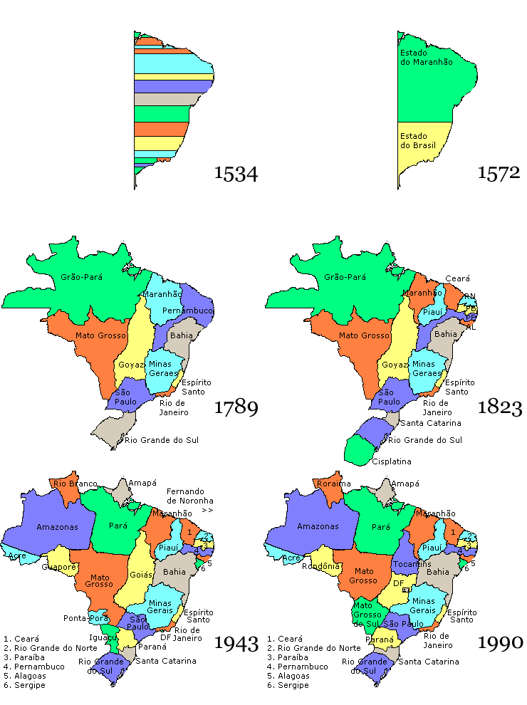
Borders over time

Brazil states.gif

Brazil in 1534.svg
Brazil in 1534:
Western border defined by the 49th meridian west
Brazil in 1572.svg
Brazil in 1572:
Western border defined by the 49th meridian west
Brazil in 1709.svg
Brazil in 1709
Brazil in 1750.svg
Brazil in 1750
Brazil in 1817.svg
Brazil in 1817
Brazil in 1822.svg
Brazil in 1822:
gained the province of Cisplatina and
enlarged the province of Rio Grande do Sul
Brazil in 1889.svg
Brazil in 1889:
lost the territory that became Uruguay and
enlarged the State of Amazonas
Brazil in 1943.svg
Brazil 1943-present:
gained the territory that comprises the State of Acre

Related Research Articles

<span class="mw-page-title-main">Geography of Brazil</span> Overview of the geography of Brazil

The country of Brazil occupies roughly half of South America, bordering the Atlantic Ocean. Brazil covers a total area of 8,514,215 km2 (3,287,357 sq mi) which includes 8,456,510 km2 (3,265,080 sq mi) of land and 55,455 km2 (21,411 sq mi) of water. The highest point in Brazil is Pico da Neblina at 2,994 m (9,823 ft). Brazil is bordered by the countries of Argentina, Bolivia, Colombia, Guyana, Paraguay, Peru, Suriname, Uruguay, Venezuela, and France.

<span class="mw-page-title-main">South America</span> Continent

South America is a continent entirely in the Western Hemisphere and mostly in the Southern Hemisphere, with a considerably smaller portion in the Northern Hemisphere. It can also be described as the southern subregion of the Americas.

This is articles is about lists of hospitals in South America. It contains links to the lists, number of articles in the category, and healthcare in each country, territory and dependency in South America.

<span class="mw-page-title-main">Tripoint</span> Geographical point at which the boundaries of three countries or subnational entities meet

A triple border, tripoint, trijunction, triple point, or tri-border area is a geographical point at which the boundaries of three countries or subnational entities meet. There are 175 international tripoints as of 2020. Nearly half are situated in rivers, lakes or seas. On dry land, the exact tripoints may be indicated by markers or pillars, and occasionally by larger monuments.

<i>Corydalus</i> Genus of insects

Corydalus is a genus of large flying insects in the Corydalidae family, commonly known as dobsonflies. They are endemic to North, Central and South America and there are about 35 known species. Members of the genus have wing lengths of up to 85 millimetres. They are sexually dimorphic, with the males having large mandibles used to grasp the females during mating while the females have smaller jaws. The larvae are known as hellgrammites and are aquatic predators.

<i>Mandevilla</i> Genus of vines

Mandevilla is a genus of tropical and subtropical flowering vines belonging to the family Apocynaceae. It was first described as a genus in 1840. A common name is rocktrumpet.

<i>Guadua</i> Genus of grasses

Guadua is a Neotropical genus of thorny, clumping bamboo in the grass family, ranging from moderate to very large species.

<i>Pouteria</i> Genus of trees

Pouteria is a genus of flowering trees in the gutta-percha family, Sapotaceae. The genus is widespread throughout the tropical Americas, with outlier species in Cameroon and Malesia. It includes the canistel, the mamey sapote, and the lucuma. Commonly, this genus is known as pouteria trees, or in some cases, eggfruits.

<i>Aspidosperma</i> Genus of plants

Aspidosperma is a genus of flowering plant in the family Apocynaceae, first described as a genus in 1824. It is native to South America, Central America, southern Mexico, and the West Indies.

<span class="mw-page-title-main">Demographics of South America</span>

As of 2017, South America has an estimated population of 418.76 million people.

<span class="mw-page-title-main">Wedge-tailed grass finch</span> Species of bird

The wedge-tailed grass finch is a species of bird in the family Thraupidae; it was formerly placed in the Emberizidae. It is found in Argentina, Bolivia, Brazil, Colombia, Costa Rica, Ecuador, French Guiana, Guyana, Panama, Paraguay, Peru, Suriname, Uruguay, and Venezuela.

<i>Aegiphila</i> Genus of flowering plants

Aegiphila is a genus of flowering plants in the mint family, Lamiaceae, first described in 1763. It was formerly classified in the Verbenaceae. It is native to Mexico, Central America, South America, the West Indies, and Florida.

<span class="mw-page-title-main">Outline of South America</span> Hierarchical outline list of articles related to South America

The following outline is provided as an overview of and topical guide to South America.

<i>Alpaida</i> (spider) Genus of spiders

Alpaida is a genus of South American orb-weaver spiders first described by Octavius Pickard-Cambridge in 1889.

<span class="mw-page-title-main">Borders of Venezuela</span>

The borders of Venezuela are the international borders that Venezuela shares with neighboring countries. Venezuela borders with 14 countries totaling 5,161 kilometers which includes territories of France, the Kingdom of the Netherlands, the United Kingdom (Montserrat) and the United States. Venezuela has the seventh largest number of land and maritime borders after France, China, the United Kingdom, Russia, the United States and Italy.

The South American territorial disputes are the territorial disputes and litigations that have developed in South America since the aftermath of the continent's wars of independence, which have shaped the current political geography of the region. These conflicts have been resolved through both military and diplomatic means. The most recent conflict in the Americas of this nature was the Cenepa War in 1995, between Ecuador and Peru.

References

  1. 1 2 3 "Brazil". CIA - The World Factbook.
  2. Switkes, Glenn (2008-03-14). "Farewell, Seven Falls". Archived from the original on 2010-01-21. Retrieved 2010-03-02.