
The Japurá River or Caquetá River is a 2,820 kilometres (1,750 mi) long river in the Amazon basin. It rises in Colombia and flows eastward through Brazil to join the Amazon River.

The Atrato River is a river of northwestern Colombia. It rises in the slopes of the Western Cordillera and flows almost due north to the Gulf of Urabá, where it forms a large, swampy delta. Its course crosses the Chocó Department, forming that department's border with neighboring Antioquia in two places. Its total length is about 650 km (400 mi), and it is navigable as far as Quibdó, the capital of the department.

José Luis Rodríguez Pittí is a Panamanian contemporary writer, video artist and documentary photographer.

The Vichada River is a blackwater river in Colombia, South America. It flows into the Orinoco River.

The Meta River is a major left tributary of the Orinoco River in eastern Colombia and southern Venezuela, South America. The Meta originates in the Eastern Ranges of the Andes and flows through the Meta Department, Colombia as the confluence of the Humea, Guatiquía and Guayuriba rivers. It flows east-northeastward across the Llanos Orientales of Colombia following the direction of the Meta Fault. The Meta forms the northern boundary of Vichada Department, first with Casanare Department, then with Arauca Department, and finally with Venezuela, down to Puerto Carreño where it flows into the Orinoco.

The Guaviare is a tributary of the Orinoco in Colombia. It flows together with the upper Orinoco, which it clearly surpasses in length and water flow. Thus, the Guaviare is hydrologically the main stream of the Orinoco system.

Florencia is a municipality and the capital city of the Department of Caquetá, Colombia. It is the most populous city in the Amazon Region of Colombia. It lies on the Orteguaza River which flows into the Caqueta River. Its population is 177,946 in 2023.
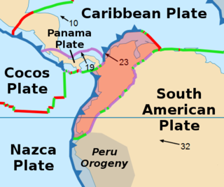
The North Andes plate or North Andes block is a small tectonic plate (microplate) located in the northern Andes. It is squeezed between the faster moving South American plate and the Nazca plate to the southwest. Due to the subduction of the Coiba and Malpelo plates, this area is very prone to volcanic and seismic activity, with many historical earthquakes.

RTVC Sistema de Medios Públicos is a public radio and television entity of Colombia, created by Decree 3525 of October 28, 2004, by dissolving Inravisión and its public production company Audiovisuales, under the government of President Álvaro Uribe Vélez.

Casanare River is a river in Colombia. It is part of the Orinoco River basin.
Tomo River is a river of Colombia. It is part of the Orinoco River basin.

The Inírida is a river in the north-west of South America, in the territory of Colombia, the largest tributary of the Guaviare.

Eliécer Silva Celis was a Colombian anthropologist, archaeologist, professor and writer. He is considered a pioneer in the anthropology of Colombia. Silva Celis is known in Colombia for the reconstruction of the Sun Temple, the most important temple of the Muisca religion.
The Honda Group is a geological group of the Upper and Middle Magdalena Basins and the adjacent Central and Eastern Ranges of the Colombian Andes. The group, in older literature also defined as formation, is in its present-day type section in the Tatacoa Desert in the department of Huila subdivided into two main formations; La Victoria and Villavieja.

The Cesar-Ranchería Basin is a sedimentary basin in northeastern Colombia. It is located in the southern part of the department of La Guajira and northeastern portion of Cesar. The basin is bound by the Oca Fault in the northeast and the Bucaramanga-Santa Marta Fault in the west. The mountain ranges Sierra Nevada de Santa Marta and the Serranía del Perijá enclose the narrow triangular intermontane basin, that covers an area of 11,668 square kilometres (4,505 sq mi). The Cesar and Ranchería Rivers flow through the basin, bearing their names.

Dejusticia is a non-profit legal organization established in 2005 that promotes human rights and the social rule of law in Colombia, Latin America and other regions of the Global South.

The Chibcha terrane, named after Chibcha, is the largest of the geological provinces (terranes) of Colombia. The terrane, the oldest explored domains of which date to the Meso- to Neoproterozoic, is situated on the North Andes Plate. The megaregional Romeral Fault System forms the contact of the terrane with the Tahamí terrane. The contact with the Caribbean and La Guajira terranes is formed by the regional Bucaramanga-Santa Marta Fault. The northeastern boundary is formed by the regional Oca Fault, bounding the La Guajira terrane. The terrane is emplaced over the Río Negro–Juruena province of the Amazonian craton along the megaregional Eastern Frontal Fault System.

The Colombianization of Leticia, Putumayo and Caquetá is the name used to designate a process of transculturation or acculturation of the areas recognized under the sovereignty of Colombia, with the purpose of transplanting Colombian cultural traditions, in replacement of those cultivated in Peru.
The National Poetry Award is an honor presented by Colombia's Ministry of Culture. In its current format, it is given biennially, in alternating years with the National Novel Award. It rewards excellence in poetic production by a Colombian citizen, living in the country or abroad, for a Spanish-language work published in the preceding two years. It includes a monetary prize of 60 million Colombian pesos.

