Madeira River

Last updated • 7 min readFrom Wikipedia, The Free Encyclopedia
Madeira River
Rio Madeira 09072007.jpg
The river in the outskirts of Porto Velho
Madeirarivermap.jpg
Map of the Madeira River watershed
EtymologyPortuguese, "wood river"
Location
Country Bolivia, Brazil
Cities Nova Olinda do Norte, Borba, Novo Aripuanã, Manicoré, Humaitá, Porto Velho
Physical characteristics
SourceConfluence of Madre de Dios and Mamoré [1] [2]
  locationNear Guayaramerín, Bolivia
  coordinates 10°38′19″S65°39′20″W / 10.63861°S 65.65556°W / -10.63861; -65.65556
  elevation180 m (590 ft)
Mouth Amazon River
  location
Amazonas, Brazil
  coordinates
3°22′32″S58°46′23″W / 3.37556°S 58.77306°W / -3.37556; -58.77306
  elevation
40 m (130 ft)
Length1,450 km (900 mi) [3]
Basin size1,376,000 km2 (531,000 sq mi)
Discharge 
  locationnear mouth
  average(Period: 1973–1990)31,200 m3/s (1,100,000 cu ft/s)
  minimum2,346 m3/s (82,800 cu ft/s)
  maximum52,804 m3/s (1,864,800 cu ft/s)
Basin features
Progression AmazonAtlantic Ocean
River system Amazon
Tributaries 
  left Madre de Dios, Abunã
  right Mamoré, Jamari, Ji-Paraná, Marmelos, Manicoré, Mataurá, Mariepauá, Aripuanã
Map of the Amazon Basin with the Madeira River highlighted Madeirarivermap.png
Map of the Amazon Basin with the Madeira River highlighted

The Madeira River (Portuguese: Rio Madeira [maˈdejɾɐ] ) is a major waterway in South America. It is estimated to be 1,450 km (900 mi) in length, while the Madeira-Mamoré is estimated near 3,250 km (2,020 mi) [4] or 3,380 km (2,100 mi) in length depending on the measuring party and their methods. The Madeira is the biggest tributary of the Amazon, accounting for about 15% of the water in the basin. [5] A map from Emanuel Bowen in 1747, held by the David Rumsey Map Collection, refers to the Madeira by the pre-colonial, indigenous name Cuyari. [6]

Contents

The River of Cuyari, called by the Portuguese Madeira or the Wood River, is formed by two great rivers, which join near its mouth. It was by this River, that the Nation of Topinambes passed into the River Amazon.

Climate

The mean inter-annual precipitations on the great basins vary from 75 to 300 cm (2.5–9.8 ft), the entire upper Madeira basin receiving 170.5 cm (5.6 ft). The greatest extremes of rainfall are between 49 and 700 cm (1.6–23 ft). Even just below the confluence that forms it, the Madeira is one of the largest rivers by discharge of the world, with a mean inter-annual discharge of 18,000 cubic metres per second (640,000 cu ft/s), i.e., 568 km3 (136 cu mi) per year, approximately half the discharge of the Congo River. On the further course towards the Amazon, the mean discharge of the Madeira increases up to 31,200 m3/s (1,100,000 cu ft/s). [7]

Course

Rapids of Teotonio before 2012 Rio Madeira- Cachoeira do Teotonio.jpg
Rapids of Teotônio before 2012

Between Guajará-Mirim and the falls of Teotônio, the Madeira receives the drainage of the north-eastern slopes of the Andes from Santa Cruz de la Sierra to Cuzco, the whole of the south-western slope of Brazilian Mato Grosso and the northern slope of the Chiquitos sierras. In total, this catchment area, which is slightly more than the combined area of all headwaters, is 850,000 km2 (330,000 sq mi), [8] almost equal in size to France and Spain combined. The waters flow into the Madeira from many large rivers, the principal of which, (from east to west), are the Guaporé or Iténez, the Baures and Blanco, the Itonamas or San Miguel, the Mamoré, Beni, and Madre de Dios or Mayutata, all of which are reinforced by numerous secondary but powerful affluents. The climate of the upper catchment area varies from humid in the western edge with the origin of the river's main stem by volume (Río Madre de Dios, Río Beni) to semi arid in the southernmost part with the Andine headwaters of the main stem by length (Río Caine, Río Rocha, Río Grande, Mamoré).

All of the upper branches of the river Madeira find their way to the falls across the open, almost level Mojos and Beni plains, 90,000 km2 (35,000 sq mi) of which are yearly flooded to an average depth of about one meter (3 ft) for a period of from three to four months.

From its source in the confluence of Madre de Dios and Mamoré rivers and downstream to Abuna River the Madeira flows northward forming border between Bolivia and Brazil. Below its confluence with the latter tributary the flow of river changes to north-eastward direction, inland of Rondônia state of Brazil. The section of the river from the border to Porto Velho has notable drop of bed and was not navigable. Before 2012 the falls of Teotônio and of San Antônio existed here, they had higher flow rate and bigger level drop than more famous Boyoma Falls in Africa. Currently these rapids are submerged by the reservoir of Santo Antônio Dam. Below Porto Velho the Madeira meanders north-eastward through the Rondônia and Amazonas states of north west Brazil to its junction with the Amazon.

The 283,117 hectares (2,800 km2; 1,100 sq mi) Rio Madeira Sustainable Development Reserve, created in 2006, extends along the north bank of the river opposite the town of Novo Aripuanã. [9] At its mouth is Ilha Tupinambaranas, an extensive marshy region formed by the Madeira's distributaries.

The Madeira river rises more than 15 m (50 ft) during the rainy season, and ocean vessels may ascend it to the Falls of San Antonio, near Porto Velho, Brazil, 1,070 km (660 mi) above its mouth; but in the dry months, from June to November, it is only navigable for the same distance for craft drawing about 2 meters (7 ft) of water. The Madeira-Mamoré Railroad runs in a 365 km (227 mi) loop around the unnavigable section to Guajará-Mirim on the Mamoré River, but is not functional, limiting shipping from the Atlantic at Porto Velho.

Today, it is also one of the Amazon basin's most active waterways, and helps export close to four million tons of grains, which are loaded onto barges in Porto Velho, where both Cargill and Amaggi have loading facilities, and then shipped down the Madeira to the ports of Itacoatiara, near the mouth of the Madeira, just upstream on the left bank of the Amazon, or further down the Amazon, to the port of Santarem, at the mouth of the Tapajos River. From these two ports, Panamax-type ships then export the grains - mainly soy and corn - to Europe and Asia. The Madeira waterway is also used to take fuel from the REMAN refinery (Petrobras) in Manaus, state capital of Amazonas, to Porto Velho, from where the states of Acre, Rondônia and parts of Mato Grosso are supplied mainly with gasoline (petrol) refined in Manaus. Cargo barges also use the Madeira on the route between Manaus and Porto Velho, which is 1,225 km (760 mi) [10] along the Rio Negro, Amazon and Madeira, connecting Manaus' industrial district with the rest of Brazil, as Manaus is land-locked as far as logistics with the rest of the country are concerned, to bring in part of its raw materials, and export its produce to the major consumer centres of São Paulo and Rio de Janeiro. In 2012, the cargo amounted to 287,835 tons [10] (both directions). The total tonnage shipped in 2012 on the Madeira accounted to 5,076,014. [10]

Two large dams (see below) are under construction as part of the IIRSA regional integration project. The dam projects include large ship-locks capable of moving oceangoing vessels between the impounded reservoir and the downstream river. If the project is completed, "more than 4,000 km [2,500 mi] of waterways upstream from the dams in Brazil, Bolivia, and Peru would become navigable." [11]

Ecology

The confluence of the Madeira River (brown) and Aripuana River (dark) near the town of Novo Aripuana. Confluence of the Madeira River and Aripuana River.jpg
The confluence of the Madeira River (brown) and Aripuanã River (dark) near the town of Novo Aripuanã.

As typical of Amazonian rivers with the primary headwaters in the Andes, the Madeira River is turbid because of high sediment levels and it is whitewater, but some of its tributaries are clearwater (e.g., Aripuanã and Ji-Paraná) or blackwater (e.g., Manicoré). [12]

The Bolivian river dolphin, variously considered a subspecies of the Amazon river dolphin or a separate species, is restricted to the upper Madeira River system. It has been estimated that there are more than 900 fish species in the Madeira River Basin, [13] making it one of the freshwater systems in the world with the highest species richness. [14]

The river is the fifth title of the 1993/1999 Philip Glass album Aguas da Amazonia .

Dams

In July 2007, plans have been approved by the Brazilian Government to construct two hydroelectric dams on the Madeira River, the Santo Antônio Dam near Porto Velho and the Jirau Dam about 100 km upstream. Both the Jirau and Santo Antonio dams are run-of-the-river projects that do not impound a large reservoir. Both dams also feature some environmental re-mediation efforts (such as fish ladders). As a consequence, it has been suggested that there has not been strong environmental opposition to the implementation of the Madeira river complex. [15] Yet, if the fish ladders fail, "several valuable migratory fish species could suffer near-extinction as a result of the Madeira dams." [16] [17] There are also concerns with deforestation and pressure on conservation areas and indigenous peoples' territories. [18] [19] The Worldwatch institute has also criticized the fast-track approval process for "kindler, gentler dams with smaller reservoirs, designed to lessen social and environmental impacts", claiming that no project should "fast-track the licensing of new dams in Amazonia and allow projects to circumvent Brazil's tough environmental laws". [16]

Languages

Indigenous languages of the upper Madeira River basin (in Brazil, Bolivia, and Peru): [20]

Note: = extinct language

ClassificationLanguage(s)LocationNo. of speakers
ArawakanMojeño (2 dialects): Ignaciano, Trinitario-†Loretano Mojos de Beni (San Ignácio, Isiboro-Sécure, Trinidad)2,000
ArawakanTerena: Terena, †Chané, dialects influenced by Guaikurusouthern Mato Grosso and southern Santa Cruz8,000 (?)
ArawakanPaunakanear Concepción (Santa Cruz)4
ArawakanBaure (3 dialects): Baure, †Muchojeone, †Paikonekasavannas in northeastern Beni and forests in northern Santa Cruz40
ArawakanParecí (3 dialects): Waimaré-Kaxiniti, Kozarini, Enawenê-Nawêtributaries of the upper Juruena River and the upper Guaporé River (Mato Grosso)800
Arawakan†Sarave(ka)Santa Cruz (border with Brazil)0
ArawakanPiro: Maniteneri, IñapariPando and Piedras River (Peru) 300
Arawakan†Lapaču / Apolista Yungas de Apolo (La Paz)0
Cariban†Palmelanortheast of Beni, near the Guaporé River 0
TupianTupi-Guarani (2 dialects): Guarayu, Kagwahibfrom the San Pablo River (Ecuador) to the Paragúa River (Santa Cruz); Rondônia and Amazonas6,000
TupianSirionó, Yukibetween Trinidad and Santa Cruz600
TupianKaritianaeast of Porto Velho 170
TupianPuruborá São Miguel River (Rondônia) 2
TupianMondé SuruíRondônia and Mato Grosso700
TupianMondé Gavião-Zoró, Cinta-Larga, Aruá, SalamãiRondônia and Mato Grosso1,800
TupianAraraRondônia and Mato Grosso150
TupianMakurapeast of Rondônia50
TupianTupariRondônia, coming from Mato Grosso150
TupianTsakirabiat, Akuntsueast of Rondônia30
TupianWayoroeast of Rondônia10
Tupian†Kepkiriwateast of Rondônia0
Panoan2 dialects: Pakawara / †Karipuna, Chácobo / †Pakaa-Novalower Beni River, Yata River and Abunã River 700
Panoan†Atsawaka, Yamiaka Madre de Dios River (Peru)0
PanoanKaxarari Abunã River (Rondônia and Amazonas)100
PanoanYaminawaAcre and Pando500
TacananAraona Madre de Dios River and Manuripi River 81
TacananEsse’ Ejja Madidi River 500
TacananCavineña Beni River and Madidi River 1,200
TacananTakanabetween the upper Beni River and Peru1,800
TacananMaropaupper Beni River 5
ChapacuranWari’ / “Pacaa-Nova” Pacaás Novos River (Rondônia)1,300
ChapacuranItene (Moré, Kautário) Cautário River (Rondônia) and Bolivia20
ChapacuranOro Winupper Pacaás Novos River 5
ChapacuranWanyam (Miguelenho) São Miguel River (Rondônia) 2
Chapacuran†Tora, †Urupalower Machado River (Rondônia)0
Chapacuran†Chapacura proper, †Nãpeka Rio Blanco (Santa Cruz)0
NambikwaranNambikwara, Northernbetween the Cabixi River and Camararé River (Mato Grosso)20
NambikwaranNambikwara, Southernbetween the upper Guaporé River and Juruena River (Mato Grosso)700
NambikwaranSabanênear Vilhena (Mato Grosso)3
YabutiDjeoromitxi Rio Branco (Rondônia) 40
YabutiArikapu (Mashubi) Rio Branco (Rondônia) 2
Macro-JêRikbaktsa (Canoeiro) Juruena River (Mato Grosso)1,000
isolateIrantxe, Myky Do Sangue River (Mato Grosso)300
isolateAikanã (Masaka, Huari) Corumbiara River and Apediá River (Rondônia)170
isolateKanoê Corumbiara River (Rondônia)5
isolateKwaza (Koaiá) Apediá River (Rondônia)25
isolateCanichana San Pedro (Mamoré River)1
isolateCayuvava Exaltación (Mamoré River)1
isolateItonamanortheast of Beni4
isolateMovima Yacuma River (Beni)1,500
isolateMosetén, Chimanenear San Borja (Beni)6,000
isolateYuracarefrom the Sécure River to the Ichilo River (Cochabamba)3,000
isolateChiquitanocentral Santa Cruz6,000
isolateMura-Pirahãmiddle Madeira River300
isolate†Matanawi Castanha River / Roosevelt River 0
Harakmbet-KatukinaHarakmbet (Amarakaeri, Wachipaeri) Madre de Dios River (Peru)650

Related Research Articles

<span class="mw-page-title-main">Amazon River</span> Major river in South America

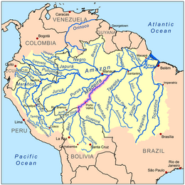
The Amazon River in South America is the largest river by discharge volume of water in the world, and the longest or second-longest river system in the world, a title which is disputed with the Nile.

<span class="mw-page-title-main">Acre (state)</span> State of Brazil

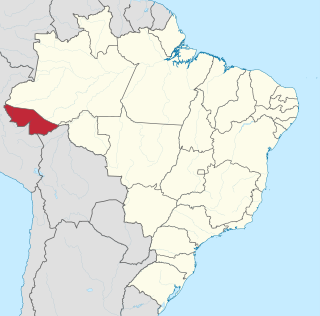
Acre is a state located in the west of the North Region of Brazil and the Amazonia Legal. Located in the westernmost part of the country, at a two-hour time difference from Brasília, Acre is bordered clockwise by the Brazilian states of Amazonas and Rondônia to the north and east, along with an international border with the Bolivian department of Pando to the southeast, and the Peruvian regions of Madre de Dios, Ucayali and Loreto to the south and west. Its capital and largest city is Rio Branco. Other important places include Cruzeiro do Sul, Sena Madureira, Tarauacá and Feijó. The state, which has 0.42% of the Brazilian population, generates 0.2% of the Brazilian GDP.

<span class="mw-page-title-main">Amazonas (Brazilian state)</span> State of Brazil

Amazonas is a state of Brazil, located in the North Region in the north-western corner of the country. It is the largest Brazilian state by area and the ninth-largest country subdivision in the world. It is the largest country subdivision in South America, being greater than the areas of Chile, Paraguay, and Uruguay combined. Neighbouring states are Roraima, Pará, Mato Grosso, Rondônia, and Acre. It also borders the nations of Peru, Colombia and Venezuela. This includes the Departments of Amazonas, Vaupés and Guainía in Colombia, as well as the Amazonas state in Venezuela, and the Loreto Region in Peru.

<span class="mw-page-title-main">Rondônia</span> State in Brazil

Rondônia is one of the 26 states of Brazil, located in the northern subdivision of the country. It is bordered by Acre in the west, Amazonas in the north, Mato Grosso in the east, and Bolivia in the south. Rondônia has a population of 1,815,000 as of 2021. It is the fifth least populated state. Its capital and largest city is Porto Velho, bathed by the Madeira River. The state was named after Cândido Rondon, who explored the north of the country during the 1910s. The state, which is home to c. 0.7% of the Brazilian population, is responsible for c. 0.3% of the Brazilian GDP.

<span class="mw-page-title-main">Porto Velho</span> Capital city of Rondônia, Brazil

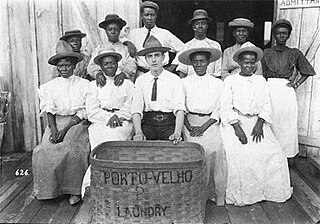
Porto Velho is the capital of the Brazilian state of Rondônia, in the upper Amazon River basin. The population is 548,952 people. Located on the border of Rondônia and the state of Amazonas, the town is an important trading center for cassiterite, the mining of which represents the most important economic activity in the region, as well as a transportation and communication center. It is on the eastern shore of the Madeira River, one of the main tributaries of the Amazon River. It is also Rondônia's largest city, and the largest state capital of Brazil by area.

<span class="mw-page-title-main">São Francisco River</span> River in Brazil

The São Francisco River is a large river in Brazil. With a length of 2,914 kilometres (1,811 mi), it is the longest river that runs entirely in Brazilian territory, and the fourth longest in South America and overall in Brazil. It used to be known as the Opara by the indigenous people before colonisation, and is today also known as "Velho Chico".

<span class="mw-page-title-main">Inland port</span> Port on an inland waterway

An inland port is a port on an inland waterway, such as a river, lake, or canal, which may or may not be connected to the sea. The term "inland port" is also used to refer to a dry port.

<span class="mw-page-title-main">Guaporé River</span> River in Bolivia, Brazil

Guaporé River is a river in western Brazil and northeastern Bolivia. It is 1,260 km (780 mi) long; 920 km (570 mi) of the river forms the border between Brazil and Bolivia.

Abunã is district in Porto Velho, the capital of Rondônia, Brazil. It is situated in the Amazon Basin on the right bank of the Madeira River 10 kilometres (6.2 mi) upstream from its confluence with the Abuna River. The Abuna River and the Madeira River upstream from their confluence mark the boundary between Brazil and Bolivia, and so Abunã is across the river from the Bolivia.

<span class="mw-page-title-main">Timeline of Amazon history</span>

This is a timeline of Amazon history, which dates back at least 11,000 years ago, when humans left indications of their presence in Caverna da Pedra Pintada.

<span class="mw-page-title-main">Caribbean Brazilians</span> Ethnic group

Caribbean Brazilians refers to Brazilians of full, partial, or predominantly Caribbean ancestry, or Caribbean-born people residing in Brazil. Many Caribbean Brazilians are of Barbadian descent.

<span class="mw-page-title-main">Jamari River</span> River in Rondônia, Brazil

The Jamari River is a river of Rondônia state in western Brazil.

<span class="mw-page-title-main">Rio Negro Bridge</span> Bridge in Amazonas, Brazil

The Journalist Phelippe Daou Bridge is the fourth longest bridge in Brazil at 3,595 metres (11,795 ft) long, with a cable-stayed bridge section of 400 metres (1,300 ft), over the Rio Negro that links the city of Manaus with the small town of Iranduba in the state of Amazonas in Brazil. It spans the Rio Negro just before its confluence with the Amazon River, and is the only major bridge across the Amazon or any tributary in the Amazon basin. Its construction was marked by controversy over the potential effects of roadbuilding in the Amazon basin, which could lead to deforestation. A 2018 study found that the construction of this bridge did induce deforestation.

<span class="mw-page-title-main">Jirau Dam</span> Dam in Rondônia, Brazil

The Jirau Dam is a rock-fill dam with an asphalt-concrete core, in the Madeira River in the state of Rondônia, Brazil. The dam's hydroelectric power stations have 50 turbines each 75 MW resulting total installed capacity of 3,750 MW. The power plant's first unit was commissioned in September 2013, the 16th in November 2014, 24th in February 2015, the 41st in December 2015, and the last in December 2016. Most of the power is designed to be exported to south-eastern Brazil via the Rio Madeira HVDC system.

<span class="mw-page-title-main">Santo Antônio Dam</span> Dam in Rondônia, Brazil

The Santo Antônio Dam is a hydroelectric dam on the Madeira River 6 km (4 mi) southwest of Porto Velho in the state of Rondônia, Brazil. The dam's run-of-the-river hydroelectric power station has 50 turbines, each rated at 71.6 MW resulting in a total installed capacity of 3,580 MW. The first unit began commercial production in March 2012, and as of June 2015 a total of 32 units were operational. The last 6 units went online in December 2016. Most of the power will be exported to south-eastern Brazil via the Rio Madeira HVDC system.

<span class="mw-page-title-main">Madeira-Mamoré Railroad</span>

The Madeira-Mamoré Railroad is an abandoned railroad built in the Brazilian state of Rondônia between 1907 and 1912, during the rubber boom. The railroad links the cities of Porto Velho and Guajará-Mirim. It became known as the "Devil's Railroad" because thousands of construction workers died from tropical diseases and violence.

<span class="mw-page-title-main">Samuel Hydroelectric Dam</span> Dam in Rondônia

The Samuel Hydroelectric Dam is a 216 MW hydroelectric dam near Porto Velho, Rondônia, Brazil. The project was controversial since it had a major environmental impact and during operations released more greenhouse gases than a comparable oil-fuelled plant.

<span class="mw-page-title-main">Mapinguari National Park</span> National Park in Rondônia and Amazonas, Brazil

Mapinguari National Park is a national park in the states of Rondônia and Amazonas, Brazil. It covers a large area of Amazon rainforest. The boundaries have been adjusted several times.

<span class="mw-page-title-main">BR-319 (Brazil highway)</span> Highway in Brazil

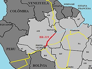
BR-319 is an 870-kilometre (540 mi) federal highway that links Manaus, Amazonas to Porto Velho, Rondônia. The highway runs through a pristine part of the Amazon rainforest. It was opened by the military government in 1973 but soon deteriorated, and by 1988 was impassable. In 2008 work began to repair the highway, which will provide an alternative to boat travel along the Madeira River or flying between Manaus and Porto Velho. Protected areas have been created along the route in an effort to prevent deforestation when BR-319 is reopened, a serious concern given the devastation caused elsewhere by highways such as BR-364. As of mid-2016 paving of the middle section of the highway had yet to be approved. Construction permits will depend on measures to prevent future damage to the forest.

References

  1. R. Ziesler and G.D. Ardizzone. LAS AGUAS CONTINENTALES DE AMERICA LATINA/THE INLAND WATERS OF LATIN AMERICA, Fishery Information, Data and Statistics Service. Fisheries Department FAO, Rome.
  2. Madeira, Visuotinė lietuvių enciklopedija
  3. Ziesler, R.; Ardizzone, G.D. (1979). "Amazon River System". The Inland waters of Latin America. Food and Agriculture Organization of the United Nations. ISBN   92-5-000780-9. Archived from the original on 21 October 2013.
  4. "Madeira (river)". Talktalk.co.uk (encyclopedia). Accessed May 2011.
  5. "Waters". Amazon Waters. Retrieved 22 January 2017.
  6. "Peru, Amazones. - David Rumsey Historical Map Collection". www.davidrumsey.com. Retrieved 16 April 2018.
  7. Seyler, Patrick; Laurence Maurice-Bourgoin; Jean Loup Guyot. "Hydrological Control on the Temporal Variability of Trace Element Concentration in the Amazon River and its Main Tributaries". Geological Survey of Brazil (CPRM). Retrieved 16 July 2013.
  8. Water and Salt Balances of the Bolivian Amazon, UNESCO
  9. RDS do Rio Madeira (in Portuguese), ISA: Instituto Socioambiental, retrieved 2016-09-01
  10. 1 2 3 "Hidrovias Brasileiras" (PDF). Agencia Nacional de Transportes Aquaviarios (ANTAQ). Archived from the original (PDF) on 13 May 2014. Retrieved 15 January 2015.
  11. Maria del Carmen Vera-Diaz (2009). Effects of Energy and Transportation Projects on Soybean Expansion in the Madeira River Basin (PDF) (Report). Conservation Strategy Fund. Archived from the original (PDF) on October 12, 2007. Retrieved July 7, 2011.
  12. Fraser; Cardoso; Junqueira; Falcão; and Clement (2009). Historical ecology and dark earths in whitewater and blackwater landscapes: comparing the Middle Madeira and Lower Negro rivers. pp. 229-264 in: Woods; Teixeira; Lehmann; Steiner; WinklerPrins; and Rebellato, eds. Amazonian Dark Earths: Wim Sombroek's Vision. ISBN   978-1-4020-9031-8
  13. de Queiroz, L.J.; Torrente-Vilara, G.; Vieira, F.G.; Ohara, W.M.; Zuanon, J.; and Doria, C.R.C. (2013). Fishes of Cuniã Lake, Madeira River Basin, Brazil. Check List 9(3): 540–548
  14. Ekström, J. (23 December 2007) Hydroelectric dam constructions in Amazonas. Retrieved 6 February 2013.
  15. "Brazil Engineers a Critic-Proof Dam". Wall Street Journal. October 6, 2010. Retrieved 2 April 2011.
  16. 1 2 "Greenwashing Hydropower". World Watch. 23 (1). Worldwatch Institute: 8–18. 2010.
  17. "Madeira River Basin: Hydropower dams in the heart of the Amazon". World Wildlife Fund Global. Archived from the original on 2 October 2012. Retrieved 7 July 2011.
  18. BBC News Online. 2007. Brazil gives Amazon dams go-ahead. 10 July. Available from: http://news.bbc.co.uk/2/hi/americas/6286804.stm. Accessed 16 July 2007.
  19. International, Survival. "Write a letter for dam-affected tribes of Brazil". www.survivalinternational.org. Retrieved 16 April 2018.
  20. Ramirez, Henri. 2006. As línguas indígenas do Alto Madeira: estatuto atual e bibliografia básica. Língua Viva vol. 01, n. 01. (PDF)