
The geography of Bolivia includes the Eastern Andes Mountain Range which bisects Bolivia roughly from north to south. To the east of that mountain chain are lowland plains of the Amazon Basin, and to the west is the Altiplano which is a highland plateau where Lake Titicaca is located. Bolivia's geography has features similar to those of Peru which abuts Bolivia's northwest border; like Bolivia, Peru is bisected from north to south by the Eastern Andes Mountains, and these two countries share Lake Titicaca which is the highest navigable lake on Earth. Unlike Peru, however, Bolivia is one of the two landlocked countries in South America, the other being Paraguay, which is located along Bolivia's southeast border.

Santa Cruz is the largest of the nine constituent departments of Bolivia, occupying about one-third (33.74%) of the country's territory. With an area of 370,621 km2 (143,098 sq mi), it is slightly smaller than Japan or the US state of Montana. It is located in the eastern part of the country, sharing borders in the north and east with Brazil and with Paraguay in the south.

Cordillera is a province in the Santa Cruz Department, Bolivia. Its capital is Lagunillas.

The Río Grande in Bolivia rises on the southern slope of the Cochabamba mountains, east of the city Cochabamba, at 17°26′11″S65°52′22″W. At its source, it is known as the Rocha River. It crosses the Cochabamba valley basin in a westerly direction, turning south east after 65 kilometres (40 mi) and after another 50 km (31 mi) joining the Arque River at 17°42′10″S66°14′45″W and an elevation of 2,350 m (7,710 ft).

Guarayos is a province in the northwestern parts of the Bolivian Santa Cruz Department.
Obispo Santistevan is one of the fifteen provinces of the Bolivian Santa Cruz department and is situated in the department's western parts. The province was founded on 2 December 1941, and its name honors Obispo Santistevan (1843–1931), famous supporter of the building of Santa Cruz Cathedral.
Manuel María Caballero Province is one of the fifteen provinces of the Bolivian Santa Cruz Department and is situated in the department's western parts. The province name honors deputy Manuel María Caballero from Vallegrande, one of the signatories of the Bolivian constitution of 5 August 1861.

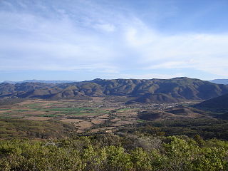
Ichilo is one of the fifteen provinces of the Bolivian Santa Cruz Department and is situated in the department's north-western parts. The province was founded by a decree of 8 April 1926 and is named after Río Ichilo which is forming the province border in the West.
Buena Vista is a small town in the Bolivian lowlands, capital of the Ichilo Province of the department of Santa Cruz. The city was founded on November 26, 1694 as the Jesuit Mission of the betrothal of the Saints of Joseph and Mary.

Andrés Ibáñez Province is one of the fifteen provinces of the Bolivian Santa Cruz Department, situated in the western part of the department. Its capital is Santa Cruz de la Sierra which is also the capital of the department.

Yapacaní is the largest city in the province of Ichilo in the Bolivian department of Santa Cruz. It lies on the west bank of the Yapacani River, at the mouth of the Surutú River, 100 km north-west of Santa Cruz de la Sierra, the largest city in Bolivia. It is the centre of the district of Yapacaní Municipio. Prior to its foundation on 23 August 1953, there was a military post called El Comando.
Entre Ríos is a small town in the Cochabamba Department of the South American Republic of Bolivia.

The Yapacaní River is a river of Bolivia, part of the Amazon River basin. The 335 kilometres (208 mi) river is a tributary of the Rio Grande. The river runs northwards through the Santa Cruz Department and joins the Mamoré River.
Chimoré Municipality is the fourth municipal section of the Carrasco Province in the Cochabamba Department, Bolivia. Its seat is Chimoré.
Montero Hoyos is a small town in the Santa Cruz Department in the South American Andean Republic of Bolivia.
Paurito is a small town in the Santa Cruz Department in the South American Andean Plurinational State of Bolivia.
Don Lorenzo is a small town in the Santa Cruz Department in the South American Andean Republic of Bolivia.
Campanero is a small town in the Santa Cruz Department in the South American Andean Republic of Bolivia.
San Juan de Yapacaní is a small town in Bolivia. San Juan de Yapacaní, officially San Juan, is a town and municipality in Bolivia, located in the province of Ichilo in the department of Santa Cruz. It is located 124 km northwest of the city of Santa Cruz de la Sierra on Route 4 on the bank of the Yapacaní River. The population is 9,191 inhabitants. The territorial extension is 1,620 km2

