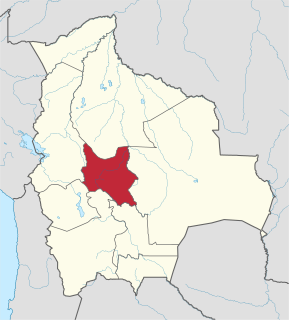
Cochabamba, from Quechua qucha or qhucha, meaning "lake", pampa meaning "plain", is one of the nine departments of Bolivia. It is known to be the "granary" of the country because of its variety of agricultural products from its geographical position. It has an area of 55,631 km2. Its population in the 2012 census was 1,758,143. Its capital is the city of Cochabamba, known as the "City of Eternal Spring" and "The Garden City" because of its spring-like temperatures all year.

Cochabamba is a city and municipality in central Bolivia in a valley in the Andes mountain range. It is the capital of the Cochabamba Department and the fourth largest city in Bolivia, with a population of 630,587 according to the 2012 Bolivian census. Its name is from a compound of the Quechua words qucha "lake" and pampa, "open plain." Residents of the city and the surrounding areas are commonly referred to as cochalas or, more formally, cochabambinos.

Arque is a rural province in Cochabamba Department in the eastern cordillera of the South American state of Bolivia.

Quillacollo is a province in the Cochabamba Department, Bolivia. It is known for its festival in August where people from all over Bolivia come and pay homage to the Virgin of Urqupiña. Quillacollo is said to be one of the fastest-growing cities in Bolivia.

Tapacarí is a province in the Cochabamba Department, Bolivia. Its capital is Tapacarí. The province is located at a turnoff from the major highway that links Cochabamba and Oruro. It has traditionally been amongst the poorest in the department. Tapacarí Province and neighboring Arque Province are the two poorest of the 16 provinces that make up the department of Cochabamba.

Quillacollo is the capital of Quillacollo Province in Cochabamba Department, Bolivia. The municipality was established on 14 September 1905 under the Presidency of Ismail Montes.

Colcapirhua or Qullqapirwa (Quechua) is the fifth municipal section of the Quillacollo Province in the Cochabamba Department, Bolivia. Its seat is Colcapirhua.

Vinto Municipality is the fourth municipal section of the Quillacollo Province in the Cochabamba Department, Bolivia. Its seat is Vinto.

Colcapirhua is a town in the Cochabamba Department in central Bolivia. It is the seat of the Colcapirhua Municipality, the fifth municipal section of the Quillacollo Province.
Pukara Mayu is a Bolivian river in the Cochabamba Department, Chapare Province, Sacaba Municipality. It is a left affluent of Mayllanku River (Maylanco) which receives the name Rocha River when it enters the Cochabamba Municipality.
Ch'aki Mayu is a Bolivian river in the Cochabamba Department, Quillacollo Province, Sipe Sipe Municipality. It is a right affluent of the Rocha River which belongs to the Amazon river basin. Ch'aki Mayu flows in a large bow from the west to the east around Sipe Sipe. The confluence with the Rocha River is south east of the town.

Jatun Q'asa is a mountain in the Tunari mountain range of the Bolivian Andes, about 5,025 m (16,486 ft) high. It is situated north-west of Cochabamba in the Cochabamba Department, Quillacollo Province, in the west of the Quillacollo Municipality.

Puma Apachita is a mountain in the Tunari mountain range of the Bolivian Andes, about 4,920 m (16,142 ft) high. It is situated in the Cochabamba Department, Quillacollo Province, Quillacollo Municipality, northwest of Cochabamba. Puma Apachita lies southeast of Jatun Q'asa.

Wayna Tunari is a mountain in the Tunari mountain range of the Bolivian Andes which reaches a height of approximately 4,800 m (15,748 ft). It is situated in the Cochabamba Department, Ayopaya Province, Morochata Municipality, and in the Quillacollo Province, Vinto Municipality. It lies northwest of Tunari.

Pirwata is a 5,060-metre-high (16,600 ft) mountain in the Bolivian Andes. It is located in the Cochabamba Department, on the border of the Ayopaya Province, Morochata Municipality, and the Quillacollo Province, Quillacollo Municipality.

Wila Qullu Punta is a 4,739-metre-high (15,548 ft) mountain in the Bolivian Andes. It is located in the Cochabamba Department, Quillacollo Province, Quillacollo Municipality.

Q'illu Suchusqa is a mountain in the Bolivian Andes which reaches a height of approximately 4,480 m (14,700 ft). It is located in the Cochabamba Department, Quillacollo Province, Quillacollo Municipality. Q'illu Suchusqa lies southwest of Wila Qullu Punta.

Kimsa Tinkuy is a mountain in the Bolivian Andes which reaches a height of approximately 4,720 m (15,490 ft). It is located in the Cochabamba Department, Quillacollo Province, Quillacollo Municipality. Kimsa Tinkuy lies northwest to west of Awila Wachana Punta and southeast of Quna Quna Q'asa.

Awila Wachana Punta is a mountain in the Bolivian Andes which reaches a height of approximately 4,720 m (15,490 ft). It is located in the Cochabamba Department, Quillacollo Province, Quillacollo Municipality. Awila Wachana Punta lies east of Kimsa Tinkuy and a lake named Warawarani.

Puka Salli is a mountain in the Bolivian Andes which reaches a height of approximately 4,640 m (15,220 ft). It is located in the Cochabamba Department, Quillacollo Province, Quillacollo Municipality. Puka Salli lies southeast of Awila Wachana Punta and northeast of a lake named Parinani Quta.


