"},"discharge1_avg":{"wt":"{{convert|2,100|m3/s|cuft/s|abbr=on}}"},"discharge1_max":{"wt":"{{cvt|4,360|m3/s|cuft/s|abbr=on}}{{cite web|url=http://www.coc.ufrj.br/es/documents2/doutorado/2006-2/860-alfredo-ribeiro-neto-doutorado/file&ved=2ahUKEwj9k6rv5or9AhX_AxAIHbTFB7EQFnoECAkQAQ&usg=AOvVaw263SiaNJvrXCQt8VjBOQzr|title=SIMULAÇÃO HIDROLÓGICA NA AMAZÔNIA: RIO MADEIRA|last1=Prof. Carlos|first1=Vieira da Silva|last2=Prof. Carlos Eduardo|first2=Norelli Tucci|last3=Prof. José|first3=Almir Cirilo|last4=Prof. Luciene|first4=Pimentel da Silva|last5=Prof. Otto|first5=Corrêa Roturno Filho|last6=Prof. Benoit|first6=Le Guennec|year=2006}}\n"},"source1":{"wt":""},"source1_location":{"wt":"Confluence of [[Pimenta Bueno River|Pimenta Bueno]] and [[Comemoração River|Comemoração]], [[Parecis plateau]], [[Rondônia]], [[Brazil]]"},"source1_coordinates":{"wt":""},"source1_elevation":{"wt":"{{cvt|173|m|abbr=on}}"},"mouth":{"wt":"[[Madeira River]]"},"mouth_location":{"wt":"[[Rondônia]], [[Brazil]]"},"mouth_coordinates":{"wt":"{{coord|-8.048599|-62.897437|format=dms|display=inline,title}}"},"mouth_elevation":{"wt":"{{cvt|43|m|abbr=on}}"},"progression":{"wt":"[[Madeira River|Madeira]] → [[Amazon River|Amazon]] → [[Atlantic Ocean]]"},"river_system":{"wt":"[[Amazon River|Amazon]]"},"basin_size":{"wt":"{{cvt|76,127|km2|mi2|abbr=on}}"},"tributaries_left":{"wt":"[[Pimenta Bueno River|Pimenta Bueno]], [[Jaru River|Jaru]], [[Rolim de Moura River|Rolim de Moura]], Muqui, [[Urupá River|Urupá]], [[Machadinho River|Machadinho]], Juruazinho, [[Preto River (Rondônia)|Preto]]"},"tributaries_right":{"wt":"[[Comemoração River|Comemoração]], [[São João River (Ji-Paraná River tributary)|São João]]"},"custom_label":{"wt":""},"custom_data":{"wt":""},"extra":{"wt":""}},"i":0}}]}" id="mwBA">River in Brazil
Ji-Paraná River Machado River | |
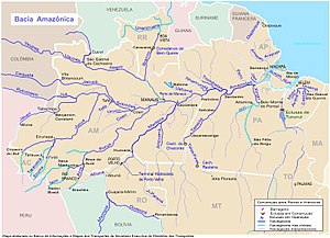
---|---|
![]() | |
Location | |
Country | Brazil |
Physical characteristics | |
Source | |
• location | Confluence of Pimenta Bueno and Comemoração, Parecis plateau, Rondônia, Brazil |
• elevation | 173 m (568 ft) |
Mouth | Madeira River |
• location | Rondônia, Brazil |
• coordinates | 8°02′55″S62°53′51″W / 8.048599°S 62.897437°W |
• elevation | 43 m (141 ft) |
Length | 820 km (510 mi) [1] |
Basin size | 76,127 km2 (29,393 sq mi) [2] |
Discharge | |
• location | Confluence of Madeira, Rondônia |
• average | 2,100 m3/s (74,000 cu ft/s) [2] |
• minimum | 596 m3/s (21,000 cu ft/s) [2] |
• maximum | 4,360 m3/s (154,000 cu ft/s) [2] |
Basin features | |
Progression | Madeira → Amazon → Atlantic Ocean |
River system | Amazon |
Tributaries | |
• left | Pimenta Bueno, Jaru, Rolim de Moura, Muqui, Urupá, Machadinho, Juruazinho, Preto |
• right | Comemoração, São João |
The Ji-Paraná River (Machado River), sometimes spelled Jiparaná, is a river in Rondônia state in western Brazil. It is a tributary of the Madeira River in the Amazon Basin. For much of its length it runs roughly parallel with the northeastern state border of Rondônia. The city of Ji-Paraná is divided by the river.
Part of the river's basin is covered by the 221,218 hectares (546,640 acres) Jacundá National Forest, a sustainable use conservation unit. [3] Part of the basin is in the 346,861 hectares (857,110 acres) Jaru Biological Reserve, a fully protected conservation unit created in 1984. [4] The river forms the southern boundary in Rondônia of the Campos Amazônicos National Park, a 961,318 hectares (2,375,470 acres) protected area created in 2006 that holds an unusual enclave of cerrado vegetation in the Amazon rainforest. [5]
Ji-Paraná is the second most populous municipality in the Brazilian state of Rondônia, with a population of 130,009, and the 16th most populous city of the Brazilian North Region, the 210th most populous city of Brazil, and the 113th of the Brazilian interior. It has an area of 6,897 km2. The city is divided by the Ji-Paraná River.
Humaitá is a municipality located in the Brazilian state of Amazonas. Its population was 56,144 (2020) and its area is 33,072 km². The city is located on the banks of the Madeira River.
Candeias do Jamari is a municipality located in the Brazilian state of Rondônia. Its population was 27,388 in 2020 and its area is 6,844 km2 (2,642 sq mi).
Machadinho d'Oeste is a municipality located in the Brazilian state of Rondônia. Its population was 40,867 (2020) and its area is 8,509 km².
Vale do Anari is a municipality located in the Brazilian state of Rondônia. Its population was 11,377 (2020) and its area is 3,135 km².
The Cupari River is a river that flows into the Tapajós in the Amazon rainforest of Brazil. Rio Cupari is in the eastern part of the Amazon River basin.
Jaru Biological Reserve is a biological reserve in the state of Rondônia, Brazil. It is part of the Southern Amazon Conservation Corridor.
The Iriri River is a large tributary of the Xingu River in Brazil, in the state of Pará. It is 1,300 km (810 mi) long making it the 116th longest river in the world and the 15th longest in the Amazon basin. The headwaters are the traditional home of the Panará people.
Dos Marmelos River is a river of Amazonas state in north-western Brazil. It is a tributary of the Madeira River, and merges into this river about 80 km (50 mi) upstream from the town of Manicoré.
Manicoré River is a river of Amazonas state in north-western Brazil. It is a tributary of the Madeira River and merges into this river about 3 km (1.9 mi) upstream from the town of Manicoré.
The Jamanxim River is a river of Pará state in north-central Brazil. Originating in the Serra do Cachimbo, it is a tributary of the Tapajós, into which it flows a few kilometers upstream from Itaituba.
The Jamari River is a river of Rondônia state in western Brazil.
The Rio Verde is a river of Rondônia state in western Brazil. It is a tributary of the Jamari River.
Cuniã Ecological Station is a strictly protected ecological station in the states of Amazonas and Rondônia, Brazil. It preserves an area of savannah parkland on the border of the Amazon rainforest. The conservation unit is rich in lakes and ponds, and serves as a nursery for various species of fish.
The Jacundá National Forest is a sustainable-use national forest in the state of Rondônia, Brazil.
Itaituba I National Forest is a national forest in the state of Pará, Brazil.
Mapinguari National Park is a national park in the states of Rondônia and Amazonas, Brazil. It covers a large area of Amazon rainforest. The boundaries have been adjusted several times.
The Humaitá National Forest is a national forest in the state of Amazonas, Brazil.
The Campos Amazônicos National Park is a National park in the states of Rondônia, Amazonas and Mato Grosso, Brazil.
The Southern Amazon Mosaic is a protected area mosaic in Brazil.