Related Research Articles

The country of Brazil occupies roughly half of South America, bordering the Atlantic Ocean. Brazil covers a total area of 8,514,215 km2 (3,287,357 sq mi) which includes 8,456,510 km2 (3,265,080 sq mi) of land and 55,455 km2 (21,411 sq mi) of water. The highest point in Brazil is Pico da Neblina at 2,994 m (9,823 ft). Brazil is bordered by the countries of Argentina, Bolivia, Colombia, Guyana, Paraguay, Peru, Suriname, Uruguay, Venezuela, and France.

The federative units of Brazil are subnational entities with a certain degree of autonomy and endowed with their own government and constitution, which together form the Federative Republic of Brazil. There are 26 states and one federal district. The states are generally based on historical, conventional borders which have developed over time. The states are divided into municipalities, while the Federal District assumes the competences of both a state and a municipality.

Rondônia is one of the 26 states of Brazil, located in the northern subdivision of the country. To the west is a short border with the state of Acre, to the north is the state of Amazonas, in the east is Mato Grosso, and in the south and southwest is Bolivia. Rondônia has a population of 1,815,000 as of 2021. It is the fifth least populated state. Its capital and largest city is Porto Velho. The state was named after Cândido Rondon, who explored the north of the country during the 1910s. The state, which is home to 0.8% of the Brazilian population, is responsible for 0.6% of the Brazilian GDP.
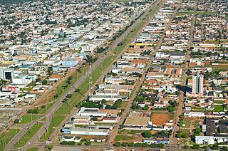
Ji-Paraná is the second most populous municipality in the Brazilian state of Rondônia, with a population of 130,009, and the 16th most populous city of the Brazilian North Region, the 210th most populous city of Brazil, and the 113th of the Brazilian interior. It has an area of 6,897 km2. The city is divided by the Ji-Paraná River.

Porto Velho is the capital of the Brazilian state of Rondônia, in the upper Amazon River basin, and a Catholic Metropolitan Archbishopric. The population is 548,952 people. Located on the border of Rondônia and the state of Amazonas, the town is an important trading center for cassiterite, the mining of which represents the most important economic activity in the region, as well as a transportation and communication center. It is on the eastern shore of the Madeira River, one of the main tributaries of the Amazon River. It is also Rondônia's largest city, and the largest state capital of Brazil by area.

The Chapacuran languages are a nearly extinct Native American language family of South America. Almost all Chapacuran languages are extinct, and the four that are extant are moribund. They are spoken in Rondônia in the southern Amazon Basin of Brazil and in northern Bolivia.

The North Region of Brazil is the largest region of Brazil, corresponding to 45.27% of the national territory. It is the second least inhabited of the country, and contributes with a minor percentage in the national GDP and population. It comprises the states of Acre, Amapá, Amazonas, Pará, Rondônia, Roraima and Tocantins.

Time in Brazil is calculated using standard time, and the country is divided into four standard time zones: UTC−02:00, UTC−03:00, UTC−04:00 and UTC−05:00.
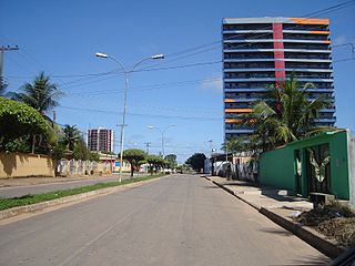
Vilhena is the easternmost municipality in the Brazilian state of Rondônia. Its population was 102,211 (IBGE-2020) and its area is 11,519 km2. It is the fifth-largest city in Rondônia and has the best HDI in the state. According to IBGE-2015, Vilhena also had a GDP of R$1.824.367,69(approximately US$460 million), which represented a GDP per capita of R$23.055,20
Aikanã is an endangered language isolate spoken by about 200 Aikanã people in Rondônia, Brazil. It is morphologically complex and has SOV word order. Aikanã uses the Latin script. The people live with speakers of Koaia (Kwaza).

The Ji-Paraná River, sometimes spelled Jiparaná, is a river in Rondônia state in western Brazil. It is a tributary of the Madeira River in the Amazon Basin. For much of its length it runs roughly parallel with the northeastern state border of Rondônia. The city of Ji-Paraná is divided by the river.

The Journalist Phelippe Dahsou Bridge is the fourth longest bridge in Brazil at 3,595-metre (11,795 ft) long with a cable-stayed bridge section of 400-metre over the Rio Negro that links the cities of Manaus and Iranduba in the state of Amazonas in Brazil. It spans the Rio Negro just before its confluence with the Amazon River, and is the only major bridge across the Amazon or any tributary in the Amazon basin. Its construction was marked by controversy over the potential effects of roadbuilding in the Amazon basin, which could lead to deforestation. A 2018 study found that the construction of this bridge did induce deforestation.
Warázu, also known as Pauserna or Guarasugwé (Guarasú'we), is a moribund Tupi–Guaraní language of Brazil. It was also formerly spoken in Bolivia. It is spoken by the Guarasugwé people, who were estimated to number 125 according to a census in 2012.
The Samuel Ecological Station is a strictly protected ecological station in the state of Rondônia, Brazil. It contains a tract of Amazon rainforest that extends east from the reservoir formed by the Samuel Hydroelectric Dam.

The Samuel Hydroelectric Dam is a 216 MW hydroelectric dam near Porto Velho, Rondônia, Brazil. The project was controversial since it had a major environmental impact and during operations released more greenhouse gases than a comparable oil-fuelled plant.

Mapinguari National Park is a national park in the states of Rondônia and Amazonas, Brazil. It covers a large area of Amazon rainforest. The boundaries have been adjusted several times.
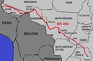
BR-364 is an inter-state highway in Brazil connecting the southeast state of São Paulo to the western state of Acre. The highway was opened in the 1960s and paved in the 1980s. It has brought economic development and population growth in the Amazon basin states of Rondônia and Acre. It has also caused massive environmental damage and socio-economic impacts. The road is extremely important for the flow of agricultural and livestock production in the states of Rondônia, Mato Grosso and Goiás, for Brazilian domestic consumption and for export, mainly by Port of Santos.
The Mamoré–Guaporé linguistic area is a linguistic area that includes over a dozen South American language families and isolates of the Mamoré–Guaporé region of eastern lowland Bolivia and Brazil.
References
Coordinates: 11°45′00″S60°55′16″W / 11.75000°S 60.92111°W