Cobija

Last updated • 2 min readFrom Wikipedia, The Free Encyclopedia
Cobija
City
Collage Cobija.png
From the top: Square and church, Monument to the Highway Effort and its Historic Carreton, Municipal government Palace, Chestnut, collection and fruits, Judicial Square, Odilon Pratagi Street y Binational Bridge Wilson Pinheiro
Flag of Cobija, Bolivia.svg
Bolivia physical map.svg
Red pog.svg
Cobija
Location in Bolivia
South America laea relief location map.jpg
Red pog.svg
Cobija
Cobija (South America)
Coordinates: 11°01′50″S68°46′00″W / 11.03056°S 68.76667°W / -11.03056; -68.76667
Country Flag of Bolivia.svg Bolivia
Department Flag of Pando.svg Pando Department
Province Nicolás Suárez
Founded1906
Government
  MayorAna Lucia Reis Melena
Area
  Total401 km2 (155 sq mi)
Elevation
280 m (919 ft)
Population
 (2020)
  Total78,555
  Density200/km2 (510/sq mi)
Time zone UTC-4 (BOT)
Area code +591 842

Cobija is a city in Bolivia, capital of the department of Pando, and is located about 600 km (373 mi.) north of La Paz in the Amazon Basin on the border with Brazil. Cobija lies on the banks of the Rio Acre across from the Brazilian city of Brasiléia. Cobija lies at an elevation of ca. 280 m (920 ft.) above sea level and has a tropical and rainy climate.

Contents

Cobija has approximately 80,000 inhabitants, is the seat of a university and capital of the Bolivian Pando Department. Cobija has two airports and is connected by one road to El Choro in the Beni Department, which is not always passable during the rainy season. When the rain allows it, Cobija is connected to the rest of Bolivia also via road. Cobija is connected to Brazil by two bridges. [1]

History

Cobija was founded in 1906 by Colonel Enrique Cornejo, originally under the name of Bahía and received its current name in 1908 in commemoration of the former Bolivian seaport Cobija on the Pacific, which has been a part of Chile since the War of the Pacific. In the early 1900s, Cobija experienced a boom as an India rubber industry center. When the industry collapsed, a major source of income being lost, Cobija became impoverished and its population fell. Nowadays, Cobija is developing again and its population is increasing. Currently, the region's primary industry is Bolivia nuts, although tourism and commerce are growing. There is a Free economic zone in the city, the largest in Bolivia. [2]

Population

The inhabitants of Cobija has risen very strongly during the past two decades to more than five-fold. Currently the estimated population is as much as 80,000 inhabitants with a population growth of 6 to 8% per year.

YearPopulationCensus
199210 001census [3]
200120 820census [4]
202078,555census [5]

Sports

The Estadio Roberto Jordán Cuellar is located in Cobija. The football stadium has a capacity of 24,000.[ citation needed ]

Climate

The city of Cobija sits on a sharp curve of the Acre river, at an altitude of 280 metres (920 ft) above sea level and in the north-western Amazon region of Bolivia. Cobija is classified as a tropical monsoon climate, Am in the Köppen classification system. Cobija has two distinct seasons, with a noticeable dry season and a wet rainy season fed by powerful thunderstorms, with hot temperatures year-round.

Climate data for Cobjia (Captain Aníbal Arab Airport), elevation 235 m (771 ft)
MonthJanFebMarAprMayJunJulAugSepOctNovDecYear
Record high °C (°F)37.2
(99.0)
35.5
(95.9)
35.0
(95.0)
36.2
(97.2)
36.0
(96.8)
35.4
(95.7)
36.7
(98.1)
38.5
(101.3)
39.5
(103.1)
38.8
(101.8)
36.6
(97.9)
36.5
(97.7)
39.5
(103.1)
Mean daily maximum °C (°F)30.8
(87.4)
30.7
(87.3)
31.0
(87.8)
30.9
(87.6)
30.2
(86.4)
30.2
(86.4)
30.7
(87.3)
32.6
(90.7)
32.5
(90.5)
32.4
(90.3)
31.5
(88.7)
31.0
(87.8)
31.2
(88.2)
Daily mean °C (°F)26.2
(79.2)
26.0
(78.8)
26.2
(79.2)
25.9
(78.6)
24.9
(76.8)
24.2
(75.6)
23.9
(75.0)
25.2
(77.4)
26.0
(78.8)
26.7
(80.1)
26.4
(79.5)
26.2
(79.2)
25.6
(78.2)
Mean daily minimum °C (°F)21.5
(70.7)
21.4
(70.5)
21.4
(70.5)
20.9
(69.6)
19.5
(67.1)
18.0
(64.4)
16.9
(62.4)
17.9
(64.2)
19.5
(67.1)
20.8
(69.4)
21.2
(70.2)
21.5
(70.7)
20.0
(68.1)
Record low °C (°F)14.8
(58.6)
15.0
(59.0)
12.8
(55.0)
11.2
(52.2)
8.0
(46.4)
9.4
(48.9)
7.0
(44.6)
7.1
(44.8)
8.0
(46.4)
10.0
(50.0)
10.5
(50.9)
14.5
(58.1)
7.0
(44.6)
Average precipitation mm (inches)260.1
(10.24)
263.9
(10.39)
244.5
(9.63)
180.5
(7.11)
85.0
(3.35)
32.2
(1.27)
23.2
(0.91)
42.3
(1.67)
98.2
(3.87)
165.9
(6.53)
227.6
(8.96)
252.3
(9.93)
1,875.7
(73.86)
Average precipitation days18.317.017.312.47.83.92.83.56.811.214.117.0132.1
Average relative humidity (%)84.184.784.483.481.780.075.171.873.977.980.982.880.1
Source: Servicio Nacional de Meteorología e Hidrología de Bolivia [6] [7]

Transportation

Cobija is served by major Bolivian airlines at Captain Aníbal Arab Airport [8] and by buses to Riberalta. The Interoceanic Highway passes through the city of Cobija.

11°02′S68°44′W / 11.033°S 68.733°W / -11.033; -68.733

Related Research Articles

Apolo is a location in the Franz Tamayo Province in the La Paz Department, Bolivia, South America, with a population of 2,123 in the year 2001. It is the seat of the Apolo Municipality.

<span class="mw-page-title-main">Riberalta</span> Town and municipality in Beni Department, Bolivia

Riberalta is a town in the Beni Department in northern Bolivia, situated where the Madre de Dios River joins the Beni River. Riberalta is on the south bank of the Beni River.

<span class="mw-page-title-main">Villa Tunari</span> Place in Cochabamba Department, Bolivia

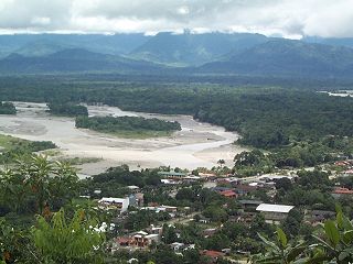
Villa Tunari or Tunari is a location in the department of Cochabamba, Bolivia. It is the seat of the Villa Tunari Municipality, the third municipal section of the Chapare Province. According to the census 2012 the population was 3,213 in the town which is an increment from 2,510 registered during the 2001 census.

<span class="mw-page-title-main">San Borja, Bolivia</span> City in Beni Department, Bolivia

San Borja is a city in the Beni Department in northern Bolivia, It is the most populous city in the province of General José Ballivián.

<span class="mw-page-title-main">Monteagudo, Bolivia</span> Place in Chuquisaca, Bolivia

Monteagudo is a small town in South Eastern Bolivia. Its name is dedicated to Bernardo de Monteagudo Cáceres (1789-1825) who took part in the Chuquisaca revolution of 25 May 1809.

Pocona is a location in the Cochabamba Department in central Bolivia. It is the seat of the Pocona Municipality, the third municipal section of the Carrasco Province. At the time of census 2001 it had a population of 244.

Batallas is a location in the La Paz Department in Bolivia. It is the seat of the Batallas Municipality, one of the four municipalities of the Los Andes Province.

Caquiaviri is a location in the La Paz Department in Bolivia. It is the seat of the Caquiaviri Municipality, the second municipal section of the Pacajes Province.

Coripata is a town in the La Paz Department, Bolivia.

<span class="mw-page-title-main">Irupana</span> Town in La Paz Department, Bolivia

Irupana is a location in the La Paz Department in Bolivia. It is the seat of the Irupana Municipality, the second municipal section of the Sud Yungas Province.

Luribay is a location in the La Paz Department in Bolivia. It is the seat of the Luribay Municipality, the first municipal section of the José Ramón Loayza Province, and of the province.

<span class="mw-page-title-main">Puerto Acosta</span> Town in La Paz Department, Bolivia

Puerto Acosta or Waychu (Aymara) is a town in the La Paz Department, Bolivia.

<span class="mw-page-title-main">Tiquipaya</span> Town in Cochabamba Department, Bolivia

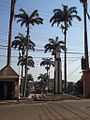
Tiquipaya is a town in the Cochabamba Department in central Bolivia. It is the seat of the Tiquipaya Municipality, the third municipal section of the Quillacollo Province. It is known as the "city of flowers". The town hosts many dairy farmers and is known as a well visited and productive zone with surprising climatic diversity due to valleys, high plains, and sub-tropical regions. The town homes the Universidad del Valle (UNIVALLE) that helps in the economy of the region as a result of the services required. Around 2% of the population of Tiquipaya was born in a foreign country. Most of them are students from Brasil.

San Ramón is a small town in the Beni Department in Bolivia.

<span class="mw-page-title-main">Cotoca</span> Town in Santa Cruz Department, Bolivia

Cotoca is a canton and Municipality of Andrés Ibáñez Province in Santa Cruz Department, Bolivia. The municipality consists of two cantons – Cotoca itself and Puerto Pailas. In 2010 it had an estimated population of 23,951 for the canton and 56,451 for the municipality.

<span class="mw-page-title-main">Puerto Rico, Pando</span> Town in Pando Department, Bolivia

Puerto Rico is a small town in Pando, northern Bolivia, with an associated airport. It is located in the Manuripi-Heath Amazonian Wildlife National Reserve. Founded on May 18, 1890, it was the first departamental capital, before Cobija. It is located at the Confluence of the Manuripi and Tahuamanu Rivers. Every year, in the month of June, the International Recreational Fishing Championship of Puerto Rico takes place at the river confluence, where the two rivers combine to form the river the River Orthon. This river then flows 410 km before it converges with the River Beni.

<span class="mw-page-title-main">San Agustín, Bolivia</span> Place in Potosí Department, Bolivia

San Agustín is a village located in the Potosí Department of Bolivia. It is the capital of the San Agustín Canton, San Agustín Municipality and Enrique Baldivieso Province.

Mineros is a city of Bolivia, capital of the Mineros Municipality of the Santa Cruz Department, 83 km north of the city of Santa Cruz de la Sierra. Due to the policy of the 1960s that forced the indigenous people of the Altiplano to immigrate, 23.3% of the population knows how to speak Quechua.

Puna is a village and the capital of the José María Linares Province in the Potosí Department of Bolivia.

Colcha K is a village serving as the capital of Nor Lípez Province, in the Potosí Department of Bolivia. It is also the capital of the Colcha "K" Canton and Colcha "K" Municipality.

References

  1. "Bolivia: Municipal Division (Departments and Municipalities) - Population Statistics, Charts and Map".
  2. "Zofra - Zofra Cobija".
  3. INE – Instituto Nacional de Estadística Bolivia 1992 Archived 2014-04-23 at the Wayback Machine
  4. INE – Instituto Nacional de Estadística Bolivia 2001 Archived 2016-03-03 at the Wayback Machine
  5. "Bolivia: Municipal Division (Departments and Municipalities) - Population Statistics, Charts and Map".
  6. "Base de datos Sistema Meteorológico–SISMET" (in Spanish). Servicio Nacional de Meteorología e Hidrología de Bolivia. Archived from the original on 7 June 2018. Retrieved 12 June 2024.
  7. "índices climáticos para 149 estaciones meteorológicas en Bolivia" (in Spanish). Servicio Nacional de Meteorología e Hidrología de Bolivia. Retrieved 12 June 2024.
  8. "VISIT BOLIVIA | Promoción del desarrollo del turismo sostenible en Bolivia. | la Paz - Bolivia". Archived from the original on 2018-07-11. Retrieved 2018-07-11.