
Coronie is a district of Suriname, situated on the coast. Coronie's capital city is Totness. The district border the Atlantic Ocean to the north, the Surinamese district of Saramacca to the east, the Surinamese district of Sipaliwini to the south and the Surinamese district of Nickerie to the west. The district is served by the Totness Airstrip.

Nickerie is a district of Suriname, on the north-west coast. Nickerie's capital city is Nieuw-Nickerie. Another town is Wageningen. The district borders the Atlantic Ocean to the north, the Surinamese district of Coronie to the east, the Surinamese district of Sipaliwini to the south and the region of East Berbice-Corentyne in Guyana to the west.

Sipaliwini is the largest district of Suriname, located in the south. Sipaliwini is the only district that does not have a regional capital, as it is directly administered by the national government in Paramaribo.

The Tiriyó are an Amerindian ethnic group native to parts of northern Brazil, Suriname, and Guyana. In 2014, there were approximately 3,640 Tiriyó in the three countries. They live in several major villages and a number of minor villages in the border zone between Brazil and Suriname. They speak the Tiriyó language, a member of the Cariban language family and refer to themselves as tarëno, etymologically 'people from here' or 'local people'.
Corneliskondre is a village in Suriname, located in the Boven Coppename resort of Sipaliwini District. It has a population of 70 as of 2020, and is inhabited by indigenous people of the Kalina tribe.
Sipaliwini Savanna, also called Sipaliwini, is a Tiriyó village on the Sipaliwini River in the Sipaliwini District of Suriname. The village lies next to the Sipaliwini Airstrip. The nearest village in Suriname is Alalapadu which is located 60 kilometres north on a map, but due to the twists and turns of the river, the town of Kwamalasamutu which lies 83 kilometres west is easier to reach. The Brazilian village of Missão can be reached by an unpaved path.
Kwamalasamutu, also Kwamalasamoetoe, is a Tiriyó Amerindian village in the Sipaliwini District of Suriname, and home to the granman of the northern Trios. Kwamalasamutu is the biggest village of the Tiriyó tribe.

Apetina, also known as Pïlëuwimë or Puleowime, is a village in the South Eastern jungle area of Suriname within the Tapanahony resort in the Sipaliwini District. It is located at 3°30′N55°04′W in the jungle on the small hills along the river Tapanahoni. Nearby points include Tebu Mountain, at around 347 m (1,138 ft) in height, and the Man Gandafutu waterfall. The majority of Apetina's population is the Wayana people. These Indians mostly originate from Brazil and once have fled because of tribal warfare. There also is primary school and an airstrip located near the Indian village of Apetina.

Kabalebo is a resort in Suriname, located in the Sipaliwini District. Its population at the 2012 census was 2,291.
Paloemeu or Palumeu is an Amerindian village in the interior of Suriname, situated at the site where the Paloemeu River joins the Tapanahoni River. Most inhabitants of the village are native Tiriyó Amerindians. The remainder belongs to the Wayana, and Aparai tribes. The Bosatlas in 1968 identified the village as Pepejoe which was incorrect according to the New West Indian Guide.
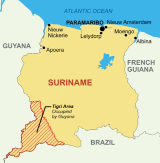
The Tigri Area is a wooded area that has been disputed by Guyana and Suriname since around 1840. It involves the area between the Upper Corentyne River, the Coeroeni River, and the Kutari River. This triangular area is known as the New River Triangle in Guyana. In 1969 the conflict ran high on, and since then it has been controlled by Guyana and claimed by Suriname. In 1971, both governments agreed that they would continue talks over the border issue and withdraw their military forces from the disputed triangle. Guyana has never held upon this agreement.
Alalapadu is a Tiriyó village in the Sipaliwini District of Suriname. The village was founded by Baptist missionaries next to the Alalapadu Airstrip in order to concentrate the Tiriyó of the area in one central village.
Amatopo or Amotopo is a Tiriyó village on the Courentyne River in the Sipaliwini District of Suriname. The village lies next to the Amatopo Airstrip and about 7 kilometres (4.3 mi) upstream from the village of Lucie. The Frederik Willem IV Falls and Arapahu Island are located near the village.
Sandlanding is a Tiriyó village in the Sipaliwini District of Suriname. The village lies just south of Apoera, which is mainly inhabited by Arowaks.
Wanapan or Arapahtë pata is a Tiriyó village in the Sipaliwini District of Suriname. It was established at the bottom of the Wonotobo Falls in 1998 by captain Arapahtë.
Lucie is a Tiriyó village at the mouth of the Lucie River in the Sipaliwini District of Suriname. The village was founded in 2004.
Kuruni is a village in the Coeroeni resort in the Sipaliwini District of Suriname. The village is inhabited by indigenous people of the Tiriyó tribe. The inhabitants are of the subgroup Aramayana or the Bee people.
Kasuela is an indigenous village of the Tiriyó people in the East Berbice-Corentyne region of Guyana. The village has a population of about 80 people. The inhabitants are of the subgroup Mawayana or the Frog people.
The Sipaliwini Savanna is a protected area and nature reserve in Suriname. The reserve is located to the south of the Sipaliwini River in the far south of the country. The reserve measures 100,000 hectares, and has been a protected area since 1972. The majority of the reserve consists of a savannah which in turn is a continuation of the Brazilian Tumucumaque Mountains National Park. The reserve is in pristine condition with almost no human habitation.

Asongo Alalaparu, also Ashongo Alalaparoe, was a Granman of the indigenous Tiriyó people in Suriname. He led the Tiriyó from 1997 to 2021 from his residence in Kwamalasamutu. During his rule, the Tiriyó established new small villages in the interior of Suriname.


