Oost, Suriname

Last updated
Oost
Paranam 2.JPG
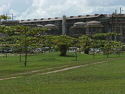
Bauxite factory at Paranam
Para Resorts Suriname Neutral.png
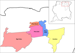
Map showing the resorts of Para District.
  Oost
CountryFlag of Suriname.svg  Suriname
District Para District
Area
  Total446 km2 (172 sq mi)
Population
 (2012) [1]
  Total8,016
  Density18/km2 (47/sq mi)
Time zone UTC-3 (AST)

Oost is a resort in Suriname, located in the Para District. Its population at the 2012 census was 8,016. [1] The main town in the resort is Paranam. Oost is also home to the former leper colony Bethesda. [2] The Paranam alumina refinery is located near the town of Paranam. [3] The Accaribo area is becoming tourist spot with the main attractions White Beach and Caribo Beach Resort. [4]

The former capital of Suriname, Torarica is located in the Oost Resort. It was settled by Portuguese Jews in 1629. One origin offered for its name is as a Portuguese coinage meaning "Opulent Torah". [5] By 1665, the village of Paramaribo was expanded and quickly outranked Torarica. [6]

The Lokono village of Powakka is located in the resort. [7]

Related Research Articles

Paramaribo is the capital and largest city of Suriname, located on the banks of the Suriname River in the Paramaribo District. Paramaribo has a population of roughly 241,000 people, almost half of Suriname's population. The historic inner city of Paramaribo has been a UNESCO World Heritage Site since 2002.

<span class="mw-page-title-main">Brokopondo District</span> District of Suriname

Brokopondo is a district of Suriname. Its capital city is Brokopondo; other towns include Brownsweg and Kwakoegron.

<span class="mw-page-title-main">Para District</span> District of Suriname

Para is a district of northern Suriname. Para's capital city is Onverwacht, with other towns including Paranam, and Zanderij. Para has a population of 24,700 and an area of 5,393 km2. The district is the mining and forestry centre of Suriname, with many large bauxite mining operations operating. The district is a mixture of forest and savannas.

<span class="mw-page-title-main">Saramacca District</span> District of Suriname

Saramacca is a district of Suriname, in the north. Saramacca's capital city is Groningen, with other towns and cities including Batavia, Kampong Baroe, Uitkijk, Maho and Boskamp. Saramacca has a population of 17,480 and an area of 3,636 km2.

<span class="mw-page-title-main">Wanica District</span> District of Suriname

Wanica is a district of Suriname located in the north of the country. Wanica's capital city is Lelydorp, the second-largest city in Suriname. Wanica has a population of 118,222 and an area of 443 km2. Following neighbouring Paramaribo, Wanica is the second most populated and urbanised district of Suriname. Two-thirds of the country's population live in these two districts.

<span class="mw-page-title-main">Brokopondo</span> District capital in Brokopondo District, Suriname

Brokopondo is the capital town of the Brokopondo District, Suriname. It is located on the west shore of the Suriname river, just north of the Afobaka dam, 105 kilometers south-east of Suriname capital city of Paramaribo. Brokopondo can be reached via the Afobakaweg from Paranam to Afobaka.

<span class="mw-page-title-main">Tapanahony</span> Resort in Sipaliwini District, Suriname

Tapanahoni is a resort in Suriname, located in the Sipaliwini District. Its population at the 2012 census was 13,808. Tapanahoni is a part of Sipaliwini which has no capital, but is directly governed from Paramaribo. Tapanahony is an enormous resort which encompasses a quarter of the country of Suriname. The most important town is Diitabiki which is the residence of the granman of the Ndyuka people since 1950, and the location of the oracle.

<span class="mw-page-title-main">Kwakoegron</span> Resort in Brokopondo, Suriname

Kwakoegron is a town and resort in Suriname. It is located inland, due south of Paramaribo. According to the 2012 census it has a population of 263, and is mainly inhabited by Maroons, of the Matawai people. The resort and town are named after Kwakoe, the native word for Wednesday, and grond, the Dutch word for ground. The captain of the resort resides in the village Commisariskondre.

<span class="mw-page-title-main">Brownsweg</span> Town and Resort in Brokopondo, Suriname

Brownsweg is a town and resort in Suriname in the Brokopondo District. Its population at the 2012 census was 4,793.

<span class="mw-page-title-main">Centrum, Brokopondo</span> Resort in Brokopondo District, Suriname

Centrum is a resort in Suriname, located in the Brokopondo District. Its population at the 2012 census was 4,482. Centrum can be reached by car via the Afobakaweg from Paranam to Afobaka, or by boat via the Suriname River.

<span class="mw-page-title-main">Johan & Margaretha</span> Resort in Commewijne District, Suriname

Johan & Margaretha or sometimes just Margaretha is a resort in Suriname, located in the Commewijne District. Its population at the 2012 census was 756. It is located along a peninsula northeast of Paramaribo. It is named after the coffee plantation Johan & Margaretha which was founded in 1745 by Johan Knöffel. It is safe to assume that his wife was called Margaretha.

<span class="mw-page-title-main">Latour, Suriname</span> Resort in Paramaribo District, Suriname

Latour is a resort in Suriname, located in the Paramaribo District. Its population at the 2012 census was 29,526. Latour is a low income neighbourhood with large unemployment. Latour is the most populous resort of Paramaribo.

<span class="mw-page-title-main">Livorno, Suriname</span> Resort in Paramaribo District, Suriname

Livorno is a resort in Suriname, located in the Paramaribo District. Its population at the 2012 census was 8,209.

<span class="mw-page-title-main">Domburg, Suriname</span> Resort in Wanica District, Suriname

Domburg is a resort in the Wanica District of Suriname, located on the northern coast of South America. Its population at the 2012 census was 5,661.

<span class="mw-page-title-main">Houttuin</span> Resort in Wanica District, Suriname

Houttuin is a resort in Suriname, located in the Wanica District. Its population at the 2012 census was 15,656. The largest ethnic group are the Indo-Surinamese. The resort is named after the sugar plantation Houttuyn which was founded in 1737. The resort was mainly agricultural, and is planned to remain an agricultural centre. In the early 21st century, it has seen a steady population growth, and is becoming suburban with housing projects like Tout Lui Faut.

<span class="mw-page-title-main">Kwatta</span> Resort in Wanica District, Suriname

Kwatta is a resort in Suriname, located in the Wanica District. Its population at the 2012 census was 14,151.

<span class="mw-page-title-main">Centrum, Paramaribo</span> Resort in Paramaribo District, Suriname

Centrum is a resort in Suriname, located in the Paramaribo District. Its population at the 2012 census was 20,631. The historical centre of Paramaribo is located within the resort. The city centre is mainly in original condition, contains 291 listed monuments, and has of 2002 been designated a Unesco World Heritage Site.

Bakhuys is a village in the Kabalebo resort of the Sipaliwini District in Suriname. The village is located near the Bakhuis Mountains. Bakhuis is mainly known for its large bauxite mine which is exploited by Suralco. In 1995, the refinery had received a $120 million upgrade and extension. The village and mountain range have been named after Louis August Bakhuis who led a 1901 expedition into the area.

Torarica is the original capital of Suriname. It was settled by Portuguese Jews in 1629. One origin offered for its name is as a Portuguese coinage meaning "Opulent Torah". The Portuguese Jews arrived via Holland and Brazil. By 1665, the village of Paramaribo was expanded and quickly outranked Torarica.

<span class="mw-page-title-main">Bethesda, Suriname</span> Former leper colony in Para District, Suriname

Bethesda was a Moravian leper colony from 1899 until 1933. The name refers to the healing of the paralytic at Bethesda by Jesus. The colony was located near Paranam in the Oost resort on the Suriname River. It was originally located on the former sugar plantation 'Great Chatillon', that already served as a leper colony of the Dutch colonial state. The Catholic leper colony 'Saint Gerardus Majella', founded in 1895 as successor of Batavia, was located nearby. In 1933 the Bethesda leper colony moved to Livorno, closer to the centre of Paramaribo, where it functioned as New Bethesda until 1964. Initially patient care at Bethesda was in the hands of German deaconesses. After the Second World War their leadership was taken over by the Dutch and the Surinamese.

References

  1. 1 2 "Resorts in Suriname Census 2012" (PDF). Retrieved 23 May 2020.
  2. "Where is Bethesda in Suriname?". Geo Targit. Retrieved 23 May 2020.
  3. "Suralco - Paranam Alumina Refinery". Industry About. Retrieved 23 May 2020.
  4. "Planning Office Suriname - Districts" (PDF). Planning Office Suriname (in Dutch). Retrieved 23 May 2020.
  5. Briggs, Philip (2015-02-01). Suriname. Bradt Travel Guides. ISBN   9781841629100.
  6. "Paramaribo Suriname 2". Suriname.nu (in Dutch). Retrieved 29 May 2020.
  7. Planning Office (2014). "Planning Office Suriname - Districts" (PDF). Planning Office Suriname (in Dutch). p. 147.

5°30′27″N55°05′33″W / 5.50750°N 55.09250°W / 5.50750; -55.09250