
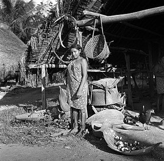
The Tiriyó are an Amerindian ethnic group native to parts of northern Brazil, Suriname, and Guyana. In 2014, there were approximately 3,640 Tiriyó in the three countries. They live in several major villages and a number of minor villages in the border zone between Brazil and Suriname. They speak the Tiriyó language, a member of the Cariban language family and refer to themselves as tarëno, etymologically 'people from here' or 'local people'.

Wageningen is a community resort and an agricultural place in the Republic of Suriname and located in the coastal area of West Suriname in the Nickerie District, at the harbour of the Nickerie River across the right estuary of the Maratakka River. The town was known as the rice centre of Suriname, Wageningen has been founded in 1949 and named after the Dutch city of Wageningen.
Washabo is a town in Suriname, located in the Kabalebo resort of Sipaliwini district. The town lies on a bend in the Corantijn river (Courantyne), on the border with Guyana. Washabo is an indigenous village of the Lokono tribe near Apoera. It has a population of about 600 people. According to the oral tradition, the village was founded in the 1920s by the Lingaard family.
Corneliskondre is a village in Suriname, located in the Boven Coppename resort of Sipaliwini District. It has a population of 70 as of 2020, and is inhabited by indigenous people of the Kalina tribe.
Kwamalasamutu, also Kwamalasamoetoe, is a Tiriyó Amerindian village in the Sipaliwini District of Suriname, and home to the granman of the northern Trios. Kwamalasamutu is the biggest village of the Tiriyó tribe.
Paloemeu or Palumeu is an Amerindian village in the interior of Suriname, situated at the site where the Paloemeu River joins the Tapanahoni River. Most inhabitants of the village are native Tiriyó Amerindians. The remainder belongs to the Wayana, and Aparai tribes. The Bosatlas in 1968 identified the village as Pepejoe which was incorrect according to the New West Indian Guide.
Amatopo or Amotopo is a Tiriyó village on the Courentyne River in the Sipaliwini District of Suriname. The village lies next to the Amatopo Airstrip and about 7 kilometres (4.3 mi) upstream from the village of Lucie. The Frederik Willem IV Falls and Arapahu Island are located near the village.
Bernharddorp is an indigenous village of Lokono and Kalina Amerindians in the resort of Noord in the Para District in Suriname.

Redi Doti is an indigenous village of Lokono and Kalina Amerindians in the resort of Carolina in the Para District in Suriname. The village is located near the site of Jodensavanne.

Kalebaskreek is an indigenous village of Kalina Amerindians in the resort of Calcutta in the Saramacca District in Suriname.
Witsanti is an indigenous village of Lokono and Kalina Amerindians in the resort of Zuid in the Para District in Suriname. The village is located on the John F. Kennedyweg near the Johan Adolf Pengel International Airport.

Cabendadorp is an indigenous village of Kalina Amerindians in the resort of Zuid in the Para District in Suriname. The village is located on the Afobakaweg south of the Johan Adolf Pengel International Airport.
Powakka is an indigenous village of Lokono Amerindians in the resort of Oost in the Para District in Suriname. The village is located on the road to Carolina which connects to the Afobakaweg to Paramaribo.
Alfonsdorp is a village of indigenous Lokono people in the Albina resort of the Marowijne District of Suriname. The village is located on the East-West Link. The Wanekreek Nature Reserve is located near the village.

Matta is an indigenous village of Lokono Amerindians in the resort of Zuid in the Para District in Suriname. The village can be accessed from a road which branches off the Southern East-West Link.
Pikin Saron is an indigenous village of Kalina Amerindians in the resort of Zuid in the Para District in Suriname. The village can be accessed from the Southern East-West Link, and is located on the Saramacca River.

Asongo Alalaparu also Ashongo Alalaparoe was a Granman of the indigenous Tiriyó people in Suriname. He led the Tiriyó from 1997 to 2021 from his residence in Kwamalasamutu. During his rule, the Tiriyó established new small villages in the interior of Suriname.

Theodoris Bernardus Jubitana was a Surinamese administrator and politician. He was captain of the indigenous village Hollandse Kamp since 2011. In addition, he was chairman of the Association of Indigenous Village Heads Suriname (VIDS) since 2017 and leader of the political party Amazon Party Suriname (APS) since 2019. He died in July 2021 from the effects of COVID-19.
Marijkedorp is a village of indigenous Lokono people in the Albina resort of the Marowijne District of Suriname. Grace Watamaleo has been the village captain since 2011.

Cassipora is an indigenous village of Lokono Amerindians in the resort of Carolina in the Para District in Suriname. The village is located near the Blaka Watra recreation area. It is also near a 17th-century Jewish village, however only the cemetery remains.
